Kings County (Prince Edward Island)

Kings County (Prince Edward Island)
Karte des Kings County

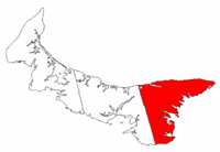
Kings County ist einer von drei Bezirken (engl. county) der kanadischen Provinz Prince Edward Island. Der Verwaltungssitz (engl. shire town) ist Georgetown, die größte Stadt Montague.

In Kings County leben 18.608 Menschen auf einer Fläche von 1684,35 km². Die Bevölkerungsdichte beträgt somit 11 Einwohner/km². Nach allen drei Angaben steht Kings County auf Platz drei der Bezirke.

Samuel Holland gründete den Bezirk 1765 in Auftrag des britischen Königs Georg III..

Geographie

Kings County ist der kleinste, ländlichste und an dünnste besiedelste Bezirk der Provinz. Kings County ist, verglichen mit den anderen Bezirken, am wenigsten von der Landwirtschaft abhängig, sondern eher mit der Fischerei und der Forstwirtschaft. Große Teile des Bezirks werden noch geforstet, hier befindet sich das größte Sägewerk der Provinz. Die einzige Industrie außer Forst- und Landwirtschaft, die in Kings County betrieben wird, ist eine kleine Werft, wenn auch einzelne Handwerks- und Gewerbebetrieb entstanden sind.

Weblinks


Wikimedia Foundation.

Игры ⚽ Нужно решить контрольную?

Schlagen Sie auch in anderen Wörterbüchern nach:

  • Kings County, Prince Edward Island — Prince Edward Island County Reference Name = Kings County Area = 1,684.35 Population = 18,608 Population Density = 11.0 Average Earnings = $36,407 Incorporated Towns = Georgetown (town), Montague (town), Souris (town) Parishes = St. Patrick s… …   Wikipedia

  • Kings Royalty, Prince Edward Island — Kings Royalty is the royalty for Kings County, Prince Edward Island, Canada.The township was established as part of the colonial survey of 1764 undertaken by Capt. Samuel J. Holland. It was intended to host the shire town of Kings County,… …   Wikipedia

  • Queens County, Prince Edward Island — Prince Edward Island County Reference Name = Queens County Area = 2,020.17 Population = 72,744 Population Density = 36.0 Average Earnings = $43,089 Incorporated Towns = Charlottetown (city), Cornwall (town), Stratford (town) Parishes = Greenville …   Wikipedia

  • Prince-Edward-Island — Île du Prince Édouard Prinz Edward Insel Wappen Flagge (Details) …   Deutsch Wikipedia

  • Queens County (Prince Edward Island) — Queens County ist einer der drei Bezirke (engl. county) der kanadischen Provinz Prince Edward Island. Der Verwaltungssitz (engl. shire town) ist Charlottetown. In Queens County leben 72.744 Menschen auf einer Fläche 2020,17 km². Die… …   Deutsch Wikipedia

  • Prince Edward Island Route 3 — Route 3 Route information Maintained by Transportation and Public Works Length: 33 km (21 mi) …   Wikipedia

  • Murray Harbour, Prince Edward Island — For the inlet on the Antarctic Peninsula, see Murray Harbour (Antarctica). Murray Harbour   Community   …   Wikipedia

  • Murray River, Prince Edward Island — Location of Murray Rive …   Wikipedia

  • Lot 39, Prince Edward Island — Infobox Settlement official name = Pagename other name = native name = nickname = settlement type = Township motto = imagesize = image caption = flag size = image seal size = image shield = shield size = city logo = citylogo size = mapsize = map… …   Wikipedia

  • Lot 38, Prince Edward Island — Infobox Settlement official name = Pagename other name = native name = nickname = settlement type = Township motto = imagesize = image caption = flag size = image seal size = image shield = shield size = city logo = citylogo size = mapsize = map… …   Wikipedia

Share the article and excerpts

Direct link
Do a right-click on the link above
and select “Copy Link”