Lake Nipissing

Lake Nipissing
Lake Nipissing
Satellitenansicht
Satellitenansicht
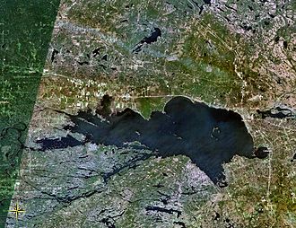
Geographische Lage Kanada
Zuflüsse Sturgeon River, South River, Rivière Veuve
Abfluss French River
Städte am Ufer North Bay
Daten
Koordinaten 46° 19′ 8″ N, 79° 50′ 25″ W46.318869444444-79.840211111111195Koordinaten: 46° 19′ 8″ N, 79° 50′ 25″ W
Lake Nipissing (Ontario)
Lake Nipissing
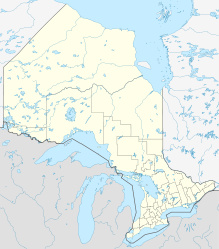
Höhe über Meeresspiegel 195 m
Fläche 873,3 km²f5
Maximale Tiefe 52 mf10

Der Lake Nipissing (französisch Lac Nipissing) ist ein See in der kanadischen Provinz Ontario.[1]

Er liegt zwischen Ottawa River und Georgian Bay und ist der fünftgrößte See Ontarios. Mit einer durchschnittlichen Tiefe von 4,5 m ist der Lake Nipissing extrem seicht. Er besitzt zahlreiche Inseln.

Die Stadt mit der größten Einwohnerzahl ist das am Nordostufer des Sees gelegene North Bay (etwa 52.000 Einwohner). Der erste Europäer, der den See sichtete, war 1610 der französische Entdecker Étienne Brûlé. Nipissing bedeutet in der Sprache der Ureinwohner „großes Wasser“ (siehe Algonkin-Sprachen).

Weblinks

Einzelnachweise

  1. The Atlas of Canada - Lakes

Wikimedia Foundation.

Игры ⚽ Нужна курсовая?

Schlagen Sie auch in anderen Wörterbüchern nach:

  • Lake Nipissing — Location Ontario Coordinates …   Wikipedia

  • Lake Nipissing Circle Tour — The Lake Nipissing Circle Tour is a tourist route that stays close to Lake Nipissing. It follows Highway 11 from intersection with former Highway 11B to the interchange with Highway 654 just south of Callander, Ontario. Turns onto Highway 534.… …   Wikipedia

  • Manitou Islands (Lake Nipissing) — Satellite image of the Manitou Islands View of Lake Nipissing from No …   Wikipedia

  • Sturgeon River (Lake Nipissing) — The Sturgeon River is a km to mi|177|precision=0 long river that springs near Lady Evelyn Smoothwater Provincial Park in the Timiskaming District in Ontario, Canada. It flows in a south easterly direction through Sudbury and Nipissing Districts… …   Wikipedia

  • Nipissing, Ontario — Nipissing Nipissing Township Museum Motto: Life the Way it Should Be. Country …   Wikipedia

  • Daisy Lake (Nipissing District, Ontario) — Coordinates: 45°39′37″N 78°56′38″W / 45.66028°N 78.94389°W / 45.66028; 78.94389 …   Wikipedia

  • Mink Lake, Nipissing District — Coordinates: 46°03′24″N 78°45′52″W / 46.05667°N 78.76444°W / 46.05667; 78.76444 …   Wikipedia

  • Nipissing, Lake — Lake, southeastern Ontario, Canada. Located midway between the Ottawa River and Georgian Bay, it is 50 mi (80 km) long and 30 mi (48 km) wide, with an area of 321 sq mi (832 sq km). A remnant of glacial Lake Algonquin, it contains many islands.… …   Universalium

  • Sturgeon Lake (Nipissing District, Ontario) — Infobox lake lake name = Sturgeon Lake image lake = caption lake = image bathymetry = caption bathymetry= location = Nipissing District, Ontario coords = coord|46|32|41|N|79|25|05|W|region:CA ON type:waterbody|display=inline,title type = inflow …   Wikipedia

  • Nipissing — may refer to the following places in Ontario, Canada: Lake Nipissing The Nipissing First Nation Nipissing 10, reserve of Nipissing First Nation Nipissing District, a census division West Nipissing, an incorporated municipality in Nipissing… …   Wikipedia

Share the article and excerpts

Direct link
Do a right-click on the link above
and select “Copy Link”