Lake Simcoe

Lake Simcoe
Lake Simcoe
Lake Simcoe Ontario.png
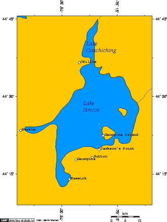
Geographische Lage Ontario (Kanada)
Zuflüsse Talbot River
Abfluss Severn River → Huronsee
Inseln Georgina Island, Thorah Island
Städte am Ufer Barrie, Orillia
Daten
Koordinaten 44° 27′ N, 79° 21′ W44.443888888889-79.355277777778219Koordinaten: 44° 27′ N, 79° 21′ W
Lake Simcoe (Ontario)
Lake Simcoe
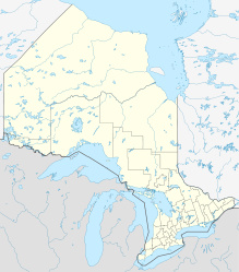
Höhe über Meeresspiegel 219 m
Fläche 723 km²[1]
Länge 30 kmf6
Breite 25 kmf7
Maximale Tiefe 41 mf10

Der Lake Simcoe ist ein See im südlichen Teil der kanadischen Provinz Ontario, etwa 70 km nördlich der Metropole Toronto gelegen. Er ist der viertgrößte See der Provinz. Zur Zeit der ersten europäischen Erkundungen im 17. Jahrhundert wurde der See von den Wyandot Ouentironk („Schönes Gewässer“) genannt. Er war auch als Lake Toronto bekannt. Frühe französische Händler nannten ihn Lac aux Claies, den „See der Wehre“, wegen der vielen Fischwehre, die dort gefunden wurden. Seinen heutigen Namen erhielt der See von John Graves Simcoe, dem Vizegouverneur von Oberkanada im späten 18. Jahrhundert.

Der See ist ca. 30 Kilometer lang und 25 Kilometer breit. Er erstreckt sich über eine Fläche von 723 km² und ist damit rund 1,3-mal so groß wie der Bodensee. Im Lake Simcoe befinden sich mehrere kleinere und größere Inseln. Die größte Insel ist Georgina Island, kleinere Inseln sind Thorah Island, Strawberry Island, Snake Island und Fox Island.

Der See ist umgeben vom Simcoe County, der Durham Region und der York Region. Größere Städte am Ufer des Sees sind Barrie und Orillia.

Der Lake Simcoe ist Teil eines größeren, prähistorischen Sees, dem Algonquin, aus dem auch der Huronsee, der Michigansee, der Obere See sowie mehrere kleinere Seen entstanden.

Laut einigen Kryptozoologen soll im See ein seehundeähnliches Ungeheuer, der Igopogo leben. Wenn das Tier in der Kempenfelt Bay, im nordöstlichen Teil des Sees, gesichtet wird, wird es Kempenfelt Kelly genannt.

Einzelnachweise

  1. Natural Resources Canada - The Atlas of Canada - Lakes

Wikimedia Foundation.

Игры ⚽ Нужна курсовая?

Schlagen Sie auch in anderen Wörterbüchern nach:

  • Lake Simcoe — Infobox lake lake name = Lake Simcoe image lake = Simcoe 79.40W 44.47N.png caption lake = satellite view image bathymetry = caption bathymetry = location = Ontario coords = coord|44|26|12|N|079|20|21|W|type:waterbody region:CA… …   Wikipedia

  • Lake Simcoe Region Conservation Authority — The Lake Simcoe Region Conservation Authority is a conservation authority established over 50 years ago, and is among the oldest in the Province of Ontario.The LSRCA is responsible for the waters, wildlife, and plants within the Lake Simcoe… …   Wikipedia

  • Lake Simcoe-Lake Huron Purchase — The Lake Simcoe Lake Huron Purchase, registered as Crown Treaty Number Sixteen, was signed November 18, 1815 between the Chippeway and the government of Upper Canada. It purchased a large portion of the lands between Lake Simcoe and Lake Huron,… …   Wikipedia

  • Barrie-Orillia (Lake Simcoe Regional) Airport — is a registered aerodrome located almost midway between Barrie and Orillia, Ontario, Canada, and operated by the Lake Simcoe Regional Airport Commission. The aerodrome has published instrument approaches.The airport is classified as an airport of …   Wikipedia

  • Snake Island (Lake Simcoe) — Snake Island is located in Lake Simcoe, Ontario, Canada.After the war of 1812, these islands, along with Fox Island and Georgina Island were purchased by Joseph Snake (a member of the Chippewas of Georgina Island First Nation from the British. It …   Wikipedia

  • Simcoe — can refer to any of the following people:# John Graves Simcoe, the first lieutenant governor of Upper Canada, now modern day southern Ontario, Canada. # Elizabeth Simcoe, the wife of John Graves Simcoe. # Anthony Simcoe, an actor.Places:# Simcoe …   Wikipedia

  • Simcoe, Lake — Lake, southeastern Ontario, Canada. Located between Georgian Bay and Lake Ontario north of Toronto, Lake Simcoe is 287 sq mi (743 sq km) in area. Numerous small streams and the Trent Canal feed the lake, which is 30 mi (48 km) long and contains… …   Universalium

  • Simcoe County Road 39 — or 20th Sideroad is a north soute tertiary route mainly in Innisfil, Ontario. 20th Sideroad is being referred to as Simcoe County Road 39 from Shores Acres Road, to Innisfil Beach Road. The road is just west of Cook s Bay, the southern end of… …   Wikipedia

  • Simcoe County — Lage des Simcoe County in Ontario Provinz Ontario County Seat Springwater …   Deutsch Wikipedia

  • Lake-effect snow — Lake Effect redirects here. For the American literary journal, see Lake Effect (journal). Lake effect precipitation coming off Lake Erie and into Western New York, as seen by NEXRAD radar, October 12–13, 2006 …   Wikipedia

Share the article and excerpts

Direct link
Do a right-click on the link above
and select “Copy Link”