- Lawrence County (South Dakota)
-
 Lawrence County Courthouse in Deadwood
Verwaltung US-Bundesstaat: South Dakota Verwaltungssitz: Deadwood Gründung: 1875 Demographie Einwohner: 21.802 (2000) Bevölkerungsdichte: 10,5 Einwohner/km² Geographie Fläche gesamt: 2.073 km² Wasserfläche: 1 km² Karte 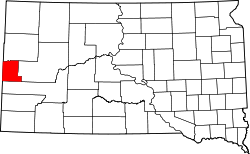
Lawrence County[1] ist ein County im Bundesstaat South Dakota der Vereinigten Staaten von Amerika. Der Sitz der Countyverwaltung (County Seat) befindet sich in Deadwood. Im Jahre 2000 lebten im County 21.802 Menschen.
Inhaltsverzeichnis
Geographie
Nach Angaben des US Census bedeckt Lawrence County eine Fläche von 2073 Quadratkilometern, davon ist 1 Quadratkilometer (0,03 Prozent) Wasserfläche. Der Bezirk besteht aus einem Township: St. Onge und zwei unorganisierten Territorien: North Lawrence und South Lawrence. Es grenzt im Uhrzeigersinn an die Countys: Butte County, Meade County, Pennington County, Weston County (Wyoming) und Crook County (Wyoming).
Bevölkerungsentwicklung
Historische Einwohnerzahlen Census Einwohner ± in % 1900 17.897 — 1910 19.694 10 % 1920 13.029 -30 % 1930 13.920 7 % 1940 19.093 40 % 1950 16.648 -10 % 1960 17.075 3 % 1970 17.453 2 % 1980 18.339 5 % 1990 20.655 10 % 2000 21.802 6 % 2010 24.097 10 % 1900–1990[2] 2000[3]
 US Route 14a W durch die Black Hills SD
 US Route 14a W durch die Black Hills SD
Altersstruktur
- unter 18 = 23,1 Prozent
- 18 - 24 = 25,4 Prozent
- 25 - 44 = 23,1 Prozent
- 45 - 64 = 14,6 Prozent
- über 65 = 11,5 Prozent
Städte und Gemeinden
Städte (cities)
- Central City
- Deadwood
- Lead
- Spearfish
- Whitewood
- North Spearfish
Einzelnachweise
- ↑ Lawrence County im Geographic Names Information System des United States Geological Survey. Abgerufen am 22. Februar 2011
- ↑ Auszug aus Census.gov. Abgerufen am 28. Februar 2011
- ↑ Auszug aus factfinder.census.gov Abgerufen am 28. Februar 2011
Weblinks
- Lawrence County, SD government website
- lawrence_county Lawrence County Journal
- Black Hills Community Portal

Liste der Countys in South Dakota
Aurora | Beadle | Bennett | Bon Homme | Brookings | Brown | Brule | Buffalo | Butte | Campbell | Charles Mix | Clark | Clay | Codington | Corson | Custer | Davison | Day | Deuel | Dewey | Douglas | Edmunds | Fall River | Faulk | Grant | Gregory | Haakon | Hamlin | Hand | Hanson | Harding | Hughes | Hutchinson | Hyde | Jackson | Jerauld | Jones | Kingsbury | Lake | Lawrence | Lincoln | Lyman | Marshall | McCook | McPherson | Meade | Mellette | Miner | Minnehaha | Moody | Pennington | Perkins | Potter | Roberts | Sanborn | Shannon | Spink | Stanley | Sully | Todd | Tripp | Turner | Union | Walworth | Yankton | Ziebach
Wikimedia Foundation.
Schlagen Sie auch in anderen Wörterbüchern nach:
Lawrence County, South Dakota — Infobox U.S. County county = Lawrence County state = South Dakota founded year = founded date = seat wl = Deadwood largest city wl = area total sq mi = 800 area total km2 = 2073 area land sq mi = 800 area land km2 = 2072 area water sq mi … Wikipedia
National Register of Historic Places listings in Lawrence County, South Dakota — Location of Lawrence County in South Dakota This is a list of the National Register of Historic Places listings in Lawrence County, South Dakota. This is intended to be a complete list of the properties and districts on the National Register of… … Wikipedia
St. Onge Township, Lawrence County, South Dakota — St. Onge Township is the sole township of Lawrence County, South Dakota, United States; the rest of the county is unorganized territory. It lies on the northern edge of the county.External links* [http://www2.census.gov/geo/maps/general… … Wikipedia
Meade County, South Dakota — Location in the state of South Dakota … Wikipedia
Minnehaha County (South Dakota) — Verwaltung US Bundesstaat: South Dakota Verwaltungssitz: Sioux Falls Adresse des Verwaltungssitzes: Gründung … Deutsch Wikipedia
Ziebach County (South Dakota) — Verwaltung US Bundesstaat: South Dakota Verwaltungssitz: Dupree Adresse des Verwaltungssitzes: Gründung … Deutsch Wikipedia
Pennington County, South Dakota — Infobox U.S. County county = Pennington County state = South Dakota founded year = founded date = seat wl = Rapid City largest city wl = Rapid City area total sq mi = 2784 area total km2 = 7211 area land sq mi =2776 area land km2 = 7190 area… … Wikipedia
Butte County, South Dakota — Infobox U.S. County county = Butte County state = South Dakota founded year = founded date = seat wl = Belle Fourche largest city wl = area total sq mi = 2266 area total km2 = 5870 area land sq mi = 2249 area land km2 = 5824 area water sq mi = 18 … Wikipedia
Hand County, South Dakota — Infobox U.S. County county = Hand County state = South Dakota founded year = 1873 founded date = seat wl = Miller largest city wl = Miller area total sq mi = 1440 area total km2 = 3730 area land sq mi = 1437 area land km2 = 3721 area water sq mi … Wikipedia
Clay County, South Dakota — Location in the state of South Dakota … Wikipedia
Lawrence County (South Dakota)


18+
© Academic, 2000-2024
- Kontaktieren Sie uns: Unterstützung, Werbung
Wörterbücher Export, schritte mit PHP, Joomla, Drupal, WordPress, MODx.