- Leflore County
-
Verwaltung US-Bundesstaat: Mississippi Verwaltungssitz: Greenwood Adresse des
Verwaltungssitzes:County Courthouse
P.O. Box 250
Greenwood, MS 38935-0250Gründung: 15. März 1871 Gebildet aus: Carroll County
Sunflower County
Tallahatchie CountyVorwahl: 001 662 Demographie Einwohner: 32.317 (2010) Bevölkerungsdichte: 21,1 Einwohner/km² Geographie Fläche gesamt: 1.570 km² Wasserfläche: 37 km² Karte 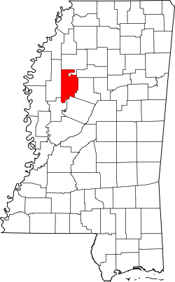
Das Leflore County[1] ist ein County im Bundesstaat Mississippi in den Vereinigten Staaten von Amerika. Bei der Volkszählung im Jahr 2010 hatte das County 32.317 Einwohner und eine Bevölkerungsdichte von 21,1 Einwohnern pro Quadratkilometer. Der Verwaltungssitz (County Seat) ist Greenwood.
Inhaltsverzeichnis
Geografie
Das County liegt im mittleren Nordwesten von Mississippi und hat eine Fläche von 1570 Quadratkilometern, wovon 37 Quadratkilometer Wasserfläche sind. Es grenzt an folgende Countys:
Tallahatchie County Grenada County Sunflower County 
Carroll County Humphreys County Holmes County Geschichte
 G. LeFlore
Das Leflore County wurde am 15. März 1871 aus Teilen des Carroll-, Sunflower- und Tallahatchie County gebildet. Benannt wurde es, wie auch die Bezirkshauptstadt, nach Greenwood LeFlore, einem Häuptling der Choctaw.
Demografische Daten
Historische Einwohnerzahlen Census Einwohner ± in % 1880 10.246 — 1890 16.869 60 % 1900 23.834 40 % 1910 36.290 50 % 1920 37.256 3 % 1930 53.506 40 % 1940 53.406 -0,2 % 1950 51.813 -3 % 1960 47.142 -9 % 1970 42.111 -10 % 1980 41.525 -1 % 1990 37.341 -10 % 2000 37.947 2 % 2010 32.317 -10 % Vor 1900[2] 1900–1990[3] 2000[4] 2010[5] Nach der Volkszählung im Jahr 2000 lebten im Leflore County 37.947 Menschen in 12.956 Haushalten und 8.887 Familien. Die Bevölkerungsdichte betrug 25 Personen pro Quadratkilometer. Ethnisch betrachtet setzte sich die Bevölkerung zusammen aus 30,00 Prozent Weißen, 67,73 Prozent Afroamerikanern, 0,11 Prozent amerikanischen Ureinwohnern, 0,65 Prozent Asiaten, 0,04 Prozent Bewohnern aus dem pazifischen Inselraum und 0,98 Prozent aus anderen ethnischen Gruppen; 0,50 Prozent stammten von zwei oder mehr Ethnien ab. 1,90 Prozent der Bevölkerung waren spanischer oder lateinamerikanischer Abstammung, die verschiedenen der genannten Gruppen angehörten.
Von den 12.956 Haushalten hatten 35,4 Prozent Kinder unter 18 Jahren, die mit ihnen lebten. 36,0 Prozent waren verheiratete, zusammenlebende Paare, 27,6 Prozent waren allein erziehende Mütter und 31,4 Prozent waren keine Familien. 28,2 Prozent aller Haushalte waren Singlehaushalte und in 11,6 Prozent lebten Menschen im Alter von 65 Jahren oder darüber. Die durchschnittliche Haushaltsgröße lag bei 2,70 und die durchschnittliche Familiengröße bei 3,33 Personen.
29,7 Prozent der Bevölkerung waren unter 18 Jahre alt, 13,1 Prozent zwischen 18 und 24, 27,0 Prozent zwischen 25 und 44, 18,2 Prozent zwischen 45 und 64 Jahre alt und 11,9 Prozent waren 65 Jahre oder älter. Das Durchschnittsalter betrug 30 Jahre. Auf 100 weibliche kamen statistisch 92,5 männliche Personen und auf 100 Frauen im Alter von 18 Jahren oder darüber kamen 87,5 Männer.
Das durchschnittliche Einkommen eines Haushaltes betrug 21.518 USD, das einer Familie 26.059 USD. Männer hatten ein durchschnittliches Einkommen von 25.959 USD, Frauen 18.497 USD. Das Pro-Kopf-Einkommen lag bei 12.553 USD. Etwa 29,1 Prozent der Familien und 34,8 Prozent der Bevölkerung lebten unterhalb der Armutsgrenze.[6]
Städte und Gemeinden
- Greenwood
- Itta Bena
- Morgan City
- Schlater
- Sidon
- Berclair
- Browning
- Minter City
- Money
- Rising Sun
- Shellmound
- Sunnyside
- Swiftown
- Quito
Einzelnachweise
- ↑ GNIS-ID: 695765. Abgerufen am 22. Februar 2011 (englisch).
- ↑ U.S. Census Bureau _ Census of Population and Housing Abgerufen am 19. Februar 2011
- ↑ Auszug aus Census.gov Abgerufen am 19. Februar 2011
- ↑ Auszug aus factfinder.census.gov Abgerufen am 18. Februar 2011
- ↑ United States Census 2010 Abgerufen am 29. Juni 2011
- ↑ Leflore County, Mississippi Datenblatt mit den Ergebnissen der Volkszählung im Jahre 2000 bei factfinder.census.gov
Weblinks
-
 Commons: Leflore County, Mississippi – Sammlung von Bildern, Videos und Audiodateien
 - Local Governments - Leflore County
- Fotos des Bezirksgerichts
- www.city-data.com

Liste der Countys in Mississippi
Adams | Alcorn | Amite | Attala | Benton | Bolivar | Calhoun | Carroll | Chickasaw | Choctaw | Claiborne | Clarke | Clay | Coahoma | Copiah | Covington | DeSoto | Forrest | Franklin | George | Greene | Grenada | Hancock | Harrison | Hinds | Holmes | Humphreys | Issaquena | Itawamba | Jackson | Jasper | Jefferson | Jefferson Davis | Jones | Kemper | Lafayette | Lamar | Lauderdale | Lawrence | Leake | Lee | Leflore | Lincoln | Lowndes | Madison | Marion | Marshall | Monroe | Montgomery | Neshoba | Newton | Noxubee | Oktibbeha | Panola | Pearl River | Perry | Pike | Pontotoc | Prentiss | Quitman | Rankin | Scott | Sharkey | Simpson | Smith | Stone | Sunflower | Tallahatchie | Tate | Tippah | Tishomingo | Tunica | Union | Walthall | Warren | Washington | Wayne | Webster | Wilkinson | Winston | Yalobusha | Yazoo
Wikimedia Foundation.
Schlagen Sie auch in anderen Wörterbüchern nach:
Leflore County — Admin ASC 2 Code Orig. name Leflore County Country and Admin Code US.MS.083 US … World countries Adminstrative division ASC I-II
Leflore County, Mississippi — Infobox U.S. County county = Leflore County state = Mississippi map size = 150 founded = 1871 seat = Greenwood | largest city = Greenwood | area total sq mi =606 area land sq mi =592 area water sq mi =14 area percentage = 2.38% census yr = 2000… … Wikipedia
Leflore County School District — The Leflore County School District is a public school district based in Leflore County, Mississippi (USA).The district serves the city of Itta Bena, the towns of Morgan City, Schlater and Sidon, as well as the community of Minter… … Wikipedia
National Register of Historic Places listings in Leflore County, Mississippi — Location of Leflore County in Mississippi This is a list of the National Register of Historic Places listings in Leflore County, Mississippi. This is intended to be a complete list of the properties and districts on the National Register of… … Wikipedia
LeFlore Preparatory Academy — Infobox Education in the United States name = John L. LeFlore Magnet High School of Advanced Communications and Fine Performing Arts imagesize = 180px motto = Striving for Excellence in Education streetaddress = 700 Donald St. 36617 Toulminville… … Wikipedia
Le Flore County — LeFlore County Courthouse, gelistet im NRHP mit der Nr. 84003099[1] Verwaltung US … Deutsch Wikipedia
Greenwood LeFlore — Infobox Person image size = caption = Greenwood LeFlore birth name = birth date = June 3, 1800 birth place = LeFleur s Bluff death date = August 31, 1865 death place = death cause = resting place = resting place coordinates = residence = Choctaw… … Wikipedia
Sunflower County, Mississippi — Infobox U.S. County county = Sunflower County state = Mississippi map size = 150 founded = 1844 seat = Indianola | largest city = Indianola | area total sq mi =707 area land sq mi =694 area water sq mi =13 area percentage = 1.90% census yr = 2000 … Wikipedia
Condado de Leflore — Condado de los Estados Unidos … Wikipedia Español
List of Mississippi county name etymologies — This is a list of Mississippi county name etymologies.*Adams County: Adams is named for the 2nd U.S. President, John Adams. *Alcorn County: Alcorn is named for Governor of Mississippi James L. Alcorn. *Amite County: Amite is based on the Latin… … Wikipedia
Leflore County


18+
© Academic, 2000-2024
- Kontaktieren Sie uns: Unterstützung, Werbung
Wörterbücher Export, schritte mit PHP, Joomla, Drupal, WordPress, MODx.