- London Borough of Bexley
-
London Borough of Bexley 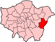
Lage in Greater LondonStatus London Borough Region Greater London Verwaltungssitz Bexleyheath Fläche 60,56 km² (261.) Einwohner (2008) 223.300 (62.) ONS-Code 00AD Website www.bexley.gov.uk Der London Borough of Bexley [ˈbɛksli] ist ein Stadtbezirk von London. Er liegt im Osten der Stadt. Bei der Gründung der Verwaltungsregion Greater London im Jahr 1965 entstand er aus folgenden Gemeinden der Grafschaft Kent: Municipal Borough of Bexley, Municipal Borough of Erith, Crayford Urban District und ein Teil des Chislehurst and Sidcup Urban District.
Im Jahr 2008 zählte der 60,56 km² große Bezirk 223.300 Einwohner, die Bevölkerungsdichte betrug 3.687 Einwohner je km². Die Bevölkerung setzte sich zusammen aus 86,5 % Weißen, 4,2 % Asiaten, 5,7 % Schwarzen und 0,9 % Chinesen.[1]
Partnerstädte sind Arnsberg und Évry.
Inhaltsverzeichnis
Stadtteile
- Albany Park
- Barnehurst
- Barnes Cray
- Belvedere
- Bexley
- Bexleyheath
- Blackfen
- Blendon
- Bostall
- Bridgen
- Coldblow
- Crayford
- Crook Log
- East Wickham
- Erith
- Falconwood
- Foots Cray
- Lamorbey
- Lessness Heath
- Longlands
- May Place
- North Cray
- North End
- Northumberland Heath
- Ruxley
- Sidcup
- Slade Green
- Thamesmead
- Upper Belvedere
- Upton
- Welling
- West Heath
Persönlichkeiten
- Kate Bush, Sängerin
- Wendy Cope, Dichterin
- Boy George, Sänger, DJ
- Robert Knox, Schauspieler
- Joseph Lister, 1. Baron Lister, Mediziner
Weblinks
 Commons: London Borough of Bexley – Sammlung von Bildern, Videos und Audiodateien
- Bexley Borough Council (Bezirksverwaltung)
Einzelnachweise
- ↑ ONS mid-2007 Ethnic Group Population Estimates. Greater London Authority, Oktober 2009, abgerufen am 23. Mai 2011 (PDF, 89 KB, englisch).
51.4413555555560.14861111111111Koordinaten: 51° 26′ N, 0° 9′ OStadtbezirke von LondonBarking and Dagenham | Barnet | Bexley | Brent | Bromley | Camden | City of London | City of Westminster | Croydon | Ealing | Enfield | Greenwich | Hackney | Hammersmith and Fulham | Haringey | Harrow | Havering | Hillingdon | Hounslow | Islington | Kensington and Chelsea | Kingston | Lambeth | Lewisham | Merton | Newham | Redbridge | Richmond | Southwark | Sutton | Tower Hamlets | Waltham Forest | Wandsworth
Sonstige Einteilung: Greater London | Inner London | Outer London | County of London
Wikimedia Foundation.
Schlagen Sie auch in anderen Wörterbüchern nach:
London Borough de Bexley — Bexley (district londonien) District londonien de Bexley Géographie Statut London borough Superficie Total Rang: 261e 60,56 km² Démographie … Wikipédia en Français
London Borough of Bexley — Infobox London Borough | name = London Borough of Bexley short name = Bexley adminhq = Broadway, Bexleyheath imagename = status = London borough | area rank = 289th area km2 = 60.56 ons code = 00AD | url = [http://www.bexley.gov.uk/ LB Bexley]… … Wikipedia
London Borough of Greenwich — Infobox London Borough | name = London Borough of Greenwich motto = We Govern by Serving short name = Greenwich imagename = status = London borough | area rank = 302nd area km2 = 47.35 ons code = 00AL | adminhq = Woolwich | ethnicity = 72.1%… … Wikipedia
London Borough of Havering — Infobox London Borough | name = London Borough of Havering short name = Havering adminhq = Main Road, Romford imagename = status = London borough | area rank = 231st area km2 = 112.27 | area link = 1 E8 m² ons code = 00AR | ethnicity = 93.2%… … Wikipedia
London Borough of Barking and Dagenham — Infobox London Borough | name = London Borough of Barking and Dagenham motto = short name = Barking and Dagenham adminhq = Rainham Road North, Becontree Heath imagename = status = London borough | area rank = 327th area km2 = 36.09 ons code =… … Wikipedia
Municipal Borough of Bexley — Bexley Motto: Non Nobis Sed Communitati (Not for ourselves but for the community) Geography Status Local board (1879 1894) Urban district (1894 1935) Municipal borough (after 1935) … Wikipedia
London Borough of Southwark — London borough Coat of arms … Wikipedia
London Borough of Harrow — London borough Coat of arms … Wikipedia
London Borough of Merton — London borough Coat of arms … Wikipedia
London Borough of Tower Hamlets — Lage in Greater London Status London Borough Region … Deutsch Wikipedia
London Borough of Bexley

18+
© Academic, 2000-2024
- Kontaktieren Sie uns: Unterstützung, Werbung
Wörterbücher Export, schritte mit PHP, Joomla, Drupal, WordPress, MODx.