- Mae Sariang
-
Mae Sariang
แม่สะเรียงProvinz: Mae Hong Son Fläche: 2.587,4 km² Einwohner: 52.024 (2005) Bev.dichte: 20,1 E./km² PLZ: 58110 Geocode: 5804 Karte 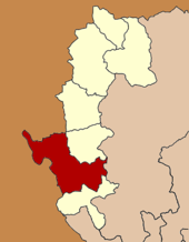
Amphoe Mae Sariang (in Thai แม่สะเรียง) ist ein Landkreis (Amphoe - Verwaltungs-Distrikt) entlang des Yuam-Flusses im Westen der Provinz Mae Hong Son. Die Provinz Mae Hong Son liegt in der Nordregion von Thailand. Die Kreishauptstadt heißt ebenfalls Mae Sariang. Sowohl die Architektur als auch der große Anteil von birmanischen Moslems erinnern an die Nähe zu Myanmar.
Geographie
Die Umgebung von Mae Sariang ist sehr bergig und von dichtem Wald bestanden. Daher ist sie ein beliebtes Ziel für Flüchtlinge aus Myanmar.
Benachbarte Bezirke (von Norden im Uhrzeigersinn): Amphoe Mae La Noi der Provinz Mae Hong Son, die Amphoe Mae Chaem und Hot der Provinz Chiang Mai, Amphoe Sop Moei wiederum in der Provinz Mae Hong Son sowie der Kayin-Staat und der Kayah-Staat von Myanmar.
Der Salawin Nationalpark liegt ebenfalls in diesem Landkreis.
Der wichtigste Fluss von Mae Sariang ist der Yuam.
Verwaltung
Amphoe Mae Sariang ist in sieben Gemeinden (Tambon) eingeteilt, welche weiterhin in 74 Dörfer (Muban) unterteilt sind.
Die Kleinstadt (Thesaban Tambon) Mae Sariang besteht aus Teilen der Tambon Ban Kat und Mae Sariang.
Außerdem gibt es sieben „Tambon Administrative Organizations“ (TAO - Verwaltungseinheiten).
No. Name Thai Dörfer Einw. 1. Ban Kat บ้านกาศ 13 11,710 2. Mae Sariang แม่สะเรียง 9 10,012 3. Mae Khong แม่คง 10 4,087 4. Mae Ho แม่เหาะ 13 8,205 5. Mae Yuam แม่ยวม 12 9,234 6. Sao Hin เสาหิน 5 2,485 8. Pa Pae ป่าแป๋ 12 6,291 Nummer 7 wird nicht mehr benutzt.
Weblinks
- http://www.maesariang.org Webseite der Stadtverwaltung Mae Sariang (in Thai)
- Webseite des Salawin Nationalparks (in Englisch)
 Amphoe von Mae Hong Son
Amphoe: Mueang Mae Hong Son | Khun Yuam | Pai | Mae Sariang | Mae La Noi | Sop Moei | Pang Mapha
18.15944444444497.933611111111Koordinaten: 18° 10′ N, 97° 56′ O


Wikimedia Foundation.