Ap Lei Chau

Ap Lei Chau

Vorlage:Infobox Insel/Wartung/Höhe fehlt

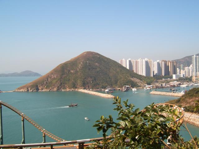
Ap Lei Chau
Mount Johnston auf Ap Lei Chau
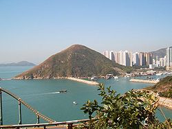
Gewässer Pazifischer Ozean
Geographische Lage 22° 14′ 30″ N, 114° 9′ 10″ O22.241666666667114.15277777778Koordinaten: 22° 14′ 30″ N, 114° 9′ 10″ O
Ap Lei Chau (Tibet)
Ap Lei Chau
Fläche 1,32 km²
Eine Hauptstraße in Ap Lei Chau

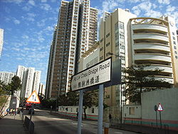
Ap Lei Chau (chinesisch 鴨脷洲) oder Aberdeen Island ist eine Insel in Hongkong, südwestlich von Hong Kong Island gelegen, nahe dem Aberdeen Harbour und dem Aberdeen Channel. Sie hat eine Fläche von 1,32 km² und ist ein Teil des Southern Districts.

Inhaltsverzeichnis

Geschichte

Ap Lei Chau diente als hervorragende Zuflucht vor Taifunen und war vor dem Ersten Opiumkrieg ein Fischerdorf. Als Folge des Vertrags von Nanking wurde die Insel zusammen mit Hong Kong Island 1841 an die Briten abgetreten. Seitdem ist die Insel wenig beachtet worden.

1968 begann die Regierung damit, ein Kraftwerk auf der Insel zu bauen, das Strom für ganz Hong Kong Island liefert. 1980 wurde eine Brücke konstruiert, die Ap Lei Chau mit Hong Kong Island verband und somit einen Impuls für eine rasche ökonomische Entwicklung auf der Insel brachte.

Geographie

Ap Lei Chau wurde nach der Form der Insel benannt, die wie die Zunge einer Ente aussieht. Ap bedeutet dabei Ente, Lei Zunge und Chau Insel. Der nördliche Teil hat die höhere Bevölkerungszahl, der Süden ist weniger dicht besiedelt.

Die höchste Erhebung auf der Insel ist der Yuk Kwai Shan (oder Mount Johnston).

Ap Lei Chau verleiht außerdem einer geologischen Formation ihren Namen, welche den Großteil von Hong Kong Island abdeckt.[1]

Mit 61.900 Menschen/km² ist Ap Lei Chau weltweit die Insel mit der zweithöchsten Bevölkerungsdichte, nach Santa Cruz del Islote, jedoch noch vor Malé (Insel).

Weblinks

 Commons: Ap Lei Chau – Sammlung von Bildern, Videos und Audiodateien

Einzelnachweise

  1. Ap Lei Chau Formation.The Geology of Hong Kong (Interactive Online)

Wikimedia Foundation.

Игры ⚽ Нужно сделать НИР?

Schlagen Sie auch in anderen Wörterbüchern nach:

  • Ap Lei Chau — (zh tcy|t=鴨脷洲|cy=aap3 lei6 jau1), or Aberdeen Island, is an island of Hong Kong, located south west of Hong Kong Island, next to Aberdeen Harbour and Aberdeen Channel, with an area of 1.32 km². Administratively, it is part of Southern District.… …   Wikipedia

  • Ap Lei Chau — 鴨脷洲 (zh) Géographie Pays …   Wikipédia en Français

  • Public housing estates in Pok Fu Lam, Aberdeen and Ap Lei Chau — The following shows the public housing estates (including Home Ownership Scheme (HOS), Private Sector Participation Scheme (PSPS), Tenants Purchase Scheme (TPS) and Sandwich Class Housing Scheme (SCHS)) in Pok Fu Lam, Aberdeen and Ap Lei Chau of… …   Wikipedia

  • Bridal Tea House Ap Lei Chau Main Street — (Гонконг,Гонконг) Категория отеля: 3 звездочный отель Адрес …   Каталог отелей

  • Ap Lei Chau Bridge — (zh tspcy|t=鴨脷洲大橋|s=鸭脷洲大桥|p=Yālìzhōu Dàqiáo|cy=ngaap3 lei6 jau1 daai6 kiu4) is a highway bridge in Hong Kong connecting the island of Ap Lei Chau and Aberdeen of the Hong Kong Island acrossing the . This bridge was made up of two lanes for each… …   Wikipedia

  • Chau Tsai Kok — (Chinese: 洲仔角) is a small uninhabited island off the island of Tap Mun in the northeastern New Territories of Hong Kong, opposite to the village of Tap Mun. It is under the administration of Tai Po District …   Wikipedia

  • Lei Tung Station — Lei Tung will be an MTR station located on Ap Lei Chau, Hong Kong, on the the HK MTR lines|South Island East. It is named after a housing estate Lei Tung Estate. Entrances/exits Lei Tung Station will have three exits. MTR proposed that some of… …   Wikipedia

  • Chau Tsai — Map of Chan Tsai and Nam Wan Kok, Tsing Yi Islands before reclamation Chau Tsai (Chinese: 洲仔) was a small island off the southern shore, Nam Wan Kok, of Tsing Yi Island of Hong Kong. It was also known as Chun Fa Rock (Chung Hue Rock), or Chung… …   Wikipedia

  • Chau Tau Station — Chau Tau 洲頭 …   Wikipedia

  • Tung Lung Chau — Map of Hong Kong showing the location of Tung Lung Chau. The cliffs on the east coast of …   Wikipedia

Share the article and excerpts

Direct link
Do a right-click on the link above
and select “Copy Link”