- Mapandan
-
Municipality of Mapandan Lage von Mapandan in der Provinz Pangasinán 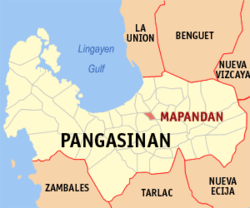
Basisdaten Bezirk: Ilocos-Region Provinz: Pangasinán Barangays: 15 Distrikt: 3. Distrikt von Pangasinán PSGC: 015528000 Einkommensklasse: 4. Einkommensklasse Haushalte: 5751 Zensus 1. Mai 2000Einwohnerzahl: 32.905 Zensus 1. August 2007Bevölkerungsdichte: 1654 Einwohner je km² Fläche: 19,9 km² Koordinaten: 16° 1′ N, 120° 27′ O16.016666666667120.45Koordinaten: 16° 1′ N, 120° 27′ O Postleitzahl: 2429 Geographische Lage auf den Philippinen 

Mapandan Mapandan ist eine Stadtgemeinde in der philippinischen Provinz Pangasinán. In dem nur 19,9 km² großen Gebiet wohnten im Jahre 2000 30.775 Menschen, wodurch sich eine Bevölkerungsdichte von 1546,4 Einwohnern pro km² ergibt. Mapandan wurde 1887 gegründet und 1909 zur Gemeinde ernannt.
Mapandan ist in folgende 15 Baranggays aufgeteilt:
- Amanoaoac
- Apaya
- Aserda
- Baloling
- Coral
- Golden
- Jimenez
- Lambayan
- Luyan
- Nilombot
- Pias
- Poblacion
- Primicias
- Santa Maria
- Torres
Städte und Stadtgemeinden in der Provinz PangasinánStädte: Alaminos | Dagupan | San Carlos City | Urdaneta
Stadtgemeinden: Agno | Aguilar | Alcala | Anda | Asingan | Balungao | Bani | Basista | Bautista | Bayambang | Binalonan | Binmaley | Bolinao | Bugallon | Burgos | Calasiao | Dasol | Infanta | Labrador | Laoac | Lingayén | Mabini | Malasiqui | Manaoag | Mangaldan | Mangatarem | Mapandan | Natividad | Pozzorubio | Rosales | San Fabian | San Jacinto | San Manuel | San Nicolas | San Quintin | Santa Barbara | Santa Maria | Santo Tomas | Sison | Sual | Tayug | Umingan | Urbiztondo | Villasis
Wikimedia Foundation.
Schlagen Sie auch in anderen Wörterbüchern nach:
Mapandan — Original name in latin Mapandan Name in other language Mapandan State code PH Continent/City Asia/Manila longitude 16.0248 latitude 120.4547 altitude 15 Population 11165 Date 2011 07 31 … Cities with a population over 1000 database
Mapandan, Pangasinan — Mapandan Municipality Seal … Wikipedia
Calasiao, Pangasinan — Calasiao Municipality Seal … Wikipedia
Manaoag, Pangasinan — Manaoag Municipality Map of Pangasinan showing the location of Manaoag … Wikipedia
Legislative districts of Pangasinan — Philippines This article is part of the series: Politics and government of the Philippines … Wikipedia
Mangaldan, Pangasinan — Mangaldan Municipality Seal … Wikipedia
Pangasinan — Infobox Philippine province name = Pangasinan sealfile = Ph seal pangasinan.png region = Ilocos Region (Region I, Pangasinan Rihiyon na Sagor na Baybay na Luzon ) capital = Lingayen founded = 1578 pop2000 = 2,645,395 pop2000rank = 3rd largest… … Wikipedia
Anda (Pangasinan) — Municipality of Anda Lage von Anda in der Provinz Pangasinán Basisdaten Bezirk: Ilocos Region … Deutsch Wikipedia
Dagupan — City Lage von Dagupan in der Provinz Pangasinán Basisdaten Bezirk: Ilocos Region … Deutsch Wikipedia
Lingayen — Municipality of Lingayén Lage von Lingayen in der Provinz Pangasinán Basisdaten Bezirk: Ilocos Region … Deutsch Wikipedia
Mapandan


18+
© Academic, 2000-2024
- Kontaktieren Sie uns: Unterstützung, Werbung
Wörterbücher Export, schritte mit PHP, Joomla, Drupal, WordPress, MODx.