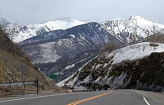
McClure Pass — View north from the summit of McClure Pass towards the Elk Mountains near Marble Elevation … Wikipedia
McClure-Pass — xx McClure Pass Blick vom Pass auf die Elk Mountains … Deutsch Wikipedia
McClure — may refer to: McClure (surname) McClure s Magazine, a popular United States illustrated monthly magazine at the turn of the 20th century McClure (crater), an impact crater on the Moon In geography: McClure, British Columbia, Canada McClure,… … Wikipedia
Robert McClure — Vicealmirante Robert McClure Nombre Robert John Le M … Wikipedia Español
Colorado State Highway 133 — State Highway 133 Route information Maintained by CDOT Length: 71.4 mi … Wikipedia
List of mountain passes — This is a list of mountain passes. Africa *Halfaya Pass *Moteng Pass (Lesotho) *Mahlasela pass (Lesotho)Asia* Khunjerab Pass Pakistan China (highest international border crossing at 4693 m.) * Khyber Pass Pakistan Afghanistan * Kotal e Lataband * … Wikipedia
Colorado mountain passes — The following tables list some important mountain passes in the Rocky Mountains of the U.S. State of Colorado. Contents 1 High elevation Colorado highways not on a pass 2 Colorado mountain passes traversed by paved highways 3 … Wikipedia
Southern Rocky Mountains — Range Mount Elbert is the highest peak of the Southern Rocky Mountains … Wikipedia
Liste der befahrbaren Pässe in Colorado — Diese Liste befahrbarer Pässe im US Bundesstaat Colorado enthält alle asphaltierten Passstraßen, die einen Namen besitzen. Name Höhe in Meter Erschließung Wasserscheide I Wasserscheide II Cameron Pass 3132 State Route 14 Michigan River Joe Wright … Deutsch Wikipedia
Pitkin County (Colorado) — Verwaltung US Bundesstaat: Colorado Verwaltungssitz: Aspen Adresse des Verwaltungssitzes: Gründung … Deutsch Wikipedia