- Miami County (Kansas)
-
Verwaltung US-Bundesstaat: Kansas Verwaltungssitz: Paola Adresse des
Verwaltungssitzes:County Courthouse
201 S. Pearl Street
Paola, KS 66071-1756Gründung: 25. August 1855 Vorwahl: 001 913 Demographie Einwohner: 32.787 (2010) Bevölkerungsdichte: 22 Einwohner/km² Geographie Fläche gesamt: 1.528 km² Wasserfläche: 35 km² Karte 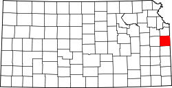
Website: www.miamicountyks.org Das Miami County[2] ist ein County im US-amerikanischen Bundesstaat Kansas. Bei der Volkszählung im Jahr 2010 hatte das County 32.787 Einwohner und eine Bevölkerungsdichte von 22 Einwohnern pro Quadratkilometer. Der Verwaltungssitz (County Seat) ist Paola.[3]
Das Miami County ist Bestandteil der Metropolregion Kansas City.
Inhaltsverzeichnis
Geografie
Das County liegt im Osten von Kansas, grenzt an Missouri und hat eine Fläche von 1.528 Quadratkilometern, wovon 35 Quadratkilometer Wasserfläche sind. Es grenzt an folgende Countys:
Douglas County Johnson County Franklin County 
Cass County
(Missouri)Anderson County Linn County Bates County
(Missouri)Geschichte
Das Miami County wurde am 25. August 1855 gebildet und gehört zu den ersten 33 Countys, die von der ersten Territorial-Verwaltung gebildet wurden. Benannt wurde es nach den Miami, einem Stamm der amerikanischen Ureinwohnern.
Historische Objekte
Nordwestlich von Osawatomie und südöstlich von Stanton auf der 335th Street befindet sich die Carey’s Ford Bridge. Die 1909 fertiggestellte Brücke wurde am 4. Januar 1990 vom National Register of Historic Places unter der Nummer 89002179 als historisches Denkmal aufgenommen.[4][5]
Demografische Daten
Historische Einwohnerzahlen Census Einwohner ± in % 1860 4980 — 1870 11.725 100 % 1880 17.802 50 % 1890 19.614 10 % 1900 21.641 10 % 1910 20.030 -7 % 1920 19.809 -1 % 1930 21.243 7 % 1940 19.489 -8 % 1950 19.698 1 % 1960 19.884 0,9 % 1970 19.254 -3 % 1980 21.618 10 % 1990 23.466 9 % 2000 28.351 20 % 2010 32.787 20 % Vor 1900[6] 1900–1990[7] 2010[8] 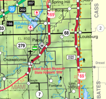 Karte des Miami Countys
Nach der Volkszählung im Jahr 2010 lebten im Miami County 32.787 Menschen in 11.543 Haushalten. Die Bevölkerungsdichte betrug 22 Einwohner pro Quadratkilometer.
Ethnisch betrachtet setzte sich die Bevölkerung zusammen aus 95,2 Prozent Weißen, 1,3 Prozent Afroamerikanern, 0,6 Prozent amerikanischen Ureinwohnern, 0,4 Prozent Asiaten sowie aus anderen ethnischen Gruppen; 1,9 Prozent stammten von zwei oder mehr Ethnien ab. Unabhängig von der ethnischen Zugehörigkeit waren 2,5 Prozent der Bevölkerung spanischer oder lateinamerikanischer Abstammung.
In den 11.543 Haushalten lebten statistisch je 2,59 Personen.
26,4 Prozent der Bevölkerung waren unter 18 Jahre alt, 62,3 Prozent waren zwischen 18 und 64 und 11,3 Prozent waren 65 Jahre oder älter. 49,9 Prozent der Bevölkerung war weiblich.
Das jährliche Durchschnittseinkommen eines Haushalts lag bei 57.705 USD. Das Pro - Kopf - Einkommen betrug 26.520 USD. 9,1 Prozent der Einwohner lebten unterhalb der Armutsgrenze.[9]
Städte und Gemeinden
- Fontana
- Louisburg
- Osawatomie
- Paola
- Spring Hill1
- Bucyrus
- Hillsdale
1 - teilweise im Johnson County
Einzelnachweise
- ↑ Auszug aus dem National Register of Historic Places. Abgerufen am 13. März 2011
- ↑ GNIS-ID: 485025. Abgerufen am 22. Februar 2011 (englisch).
- ↑ National Association of Counties Abgerufen am 18. Oktober 2011
- ↑ Auszug aus dem National Register of Historic Places. Abgerufen am 13. März 2011
- ↑ National Register of Historical Places - KANSAS (KS), Miami County
- ↑ U.S. Census Bureau - Census of Population and Housing Abgerufen am 15. März 2011
- ↑ Auszug aus Census.gov Abgerufen am 17. Februar 2011
- ↑ United States Census 2010 Abgerufen am 18. Oktober 2011
- ↑ U.S. Census Buero, State & County QuickFacts - Miami County Abgerufen am 18. Oktober 2011
Weblinks
-
 Commons: Miami County, Kansas – Sammlung von Bildern, Videos und Audiodateien
 - Offizielle Webseite
- U.S. Census Buero, State & County QuickFacts - Miami County
- Yahoo Bildersuche - Miami County
- www.city-data.com - Miami County

Liste der Countys in Kansas
Allen | Anderson | Atchison | Barber | Barton | Bourbon | Brown | Butler | Chase | Chautauqua | Cherokee | Cheyenne | Clark | Clay | Cloud | Coffey | Comanche | Cowley | Crawford | Decatur | Dickinson | Doniphan | Douglas | Edwards | Elk | Ellis | Ellsworth | Finney | Ford | Franklin | Geary | Gove | Graham | Grant | Gray | Greeley | Greenwood | Hamilton | Harper | Harvey | Haskell | Hodgeman | Jackson | Jefferson | Jewell | Johnson | Kearny | Kingman | Kiowa | Labette | Lane | Leavenworth | Lincoln | Linn | Logan | Lyon | Marion | Marshall | McPherson | Meade | Miami | Mitchell | Montgomery | Morris | Morton | Nemaha | Neosho | Ness | Norton | Osage | Osborne | Ottawa | Pawnee | Phillips | Pottawatomie | Pratt | Rawlins | Reno | Republic | Rice | Riley | Rooks | Rush | Russell | Saline | Scott | Sedgwick | Seward | Shawnee | Sheridan | Sherman | Smith | Stafford | Stanton | Stevens | Sumner | Thomas | Trego | Wabaunsee | Wallace | Washington | Wichita | Wilson | Woodson | Wyandotte
Wikimedia Foundation.
Schlagen Sie auch in anderen Wörterbüchern nach:
Miami County, Kansas — Miami County Courthouse in Paola … Wikipedia
National Register of Historic Places listings in Miami County, Kansas — Location of Miami County in Kansas This is a list of the National Register of Historic Places listings in Miami County, Kansas. This is intended to be a complete list of the properties and districts on the National Register of Historic Places in… … Wikipedia
Miami County — is the name of several counties in the United States: Miami County, Indiana Miami County, Kansas Miami County, Ohio See also Miami Dade County, Florida This disambiguation page lists articles about distinct geographical locations wit … Wikipedia
Miami County — Es gibt in den Vereinigten Staaten drei Countys mit dem Namen Miami County: Miami County (Indiana) Miami County (Kansas) Miami County (Ohio) Diese Seite ist eine Begriffsklärung zur … Deutsch Wikipedia
Miami County Courthouse — may refer to: Miami County Courthouse (Indiana), listed on the NRHP in Indiana Miami County Courthouse (Kansas), listed on the NRHP in Kansas Miami County Courthouse and Power Station in Troy, Ohio, listed on the NRHP in Ohio This disambiguation… … Wikipedia
Miami County Courthouse and Power Station — U.S. National Register of Historic Places … Wikipedia
Miami County Courthouse — bezeichnet mehrere gleichnamige, im NRHP gelistete, Objekte: Miami County Courthouse (Indiana), ID Nr. 08000194 Miami County Courthouse (Kansas), ID Nr. 73000768 weitere: Miami County Courthouse (Ohio) Diese Seite ist eine … Deutsch Wikipedia
Johnson County, Kansas — Johnson Courthouse in Olathe … Wikipedia
Douglas County, Kansas — Douglas County Courthouse in Lawrence … Wikipedia
Johnson County (Kansas) — Das Johnson County Courthouse in Olathe Verwaltung US Bundesstaat: Kansas … Deutsch Wikipedia
Miami County (Kansas)


18+
© Academic, 2000-2024
- Kontaktieren Sie uns: Unterstützung, Werbung
Wörterbücher Export, schritte mit PHP, Joomla, Drupal, WordPress, MODx.