Nambucca Shire

Nambucca Shire
Shire of Nambucca
Australia-Map-NSW-LGA-Nambucca.png
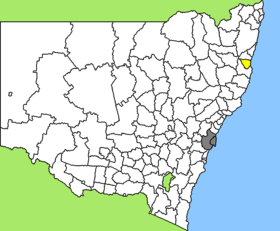
Lage des Nambucca Shire in New South Wales
Gliederung
Staat: Australien Australien
Bundesstaat: Flag of New South Wales.svg New South Wales
Verwaltungssitz: Macksville
Daten und Zahlen
Fläche: 1.491 km²
Einwohner: 17.897 (2006) [1]
Bevölkerungsdichte: 12 Einwohner je km²
-30.716666666667152.81666666667

Nambucca Shire ist ein lokales Verwaltungsgebiet (LGA) im australischen Bundesstaat New South Wales. Das Gebiet ist 1.491 km² groß und hat etwa 18.000 Einwohner.

Nambucca liegt an der Ostküste des Staates an der Mid-North Coast etwa 450 km nördlich der Metropole Sydney und 460 km südlich von Brisbane. Das Gebiet umfasst 70 Ortsteile und Ortschaften, darunter Argents Hill, Bowraville, Burrapine, Eungai Creek, Macksville, Missabotti, Nambucca Heads, Scotts Head, Talarm, Taylors Arm, Utungun, Valla und Warrell Creek. Der Sitz des Shire Councils befindet sich in der Stadt Macksville in im Osten der LGA, wo etwa 2.700 Einwohner leben.

Verwaltung

Der Nambucca Shire Council hat neun Mitglieder, die von den Bewohnern der LGA gewählt werden. Nambucca ist nicht in Bezirke untergliedert, die acht Councillor und der Vorsitzende und Mayor (Bürgermeister) werden von allen Bewohnern der LGA direkt gewählt.

Weblinks

Einzelnachweise

  1. Australian Bureau of Statistics (25. Oktober 2007): Nambucca (A) (Local Government Area) (Englisch). 2006 Census QuickStats. Abgerufen am 6. April 2010.

Wikimedia Foundation.

Игры ⚽ Нужно сделать НИР?

Schlagen Sie auch in anderen Wörterbüchern nach:

  • Nambucca Shire — New South Wales Location in New South Wales Population: 19,186(200 …   Wikipedia

  • Nambucca Shire — Admin ASC 2 Code Orig. name Nambucca Shire Country and Admin Code AU.02.15700 AU …   World countries Adminstrative division ASC I-II

  • Nambucca Shire Council — Infobox Australian Place | type = lga name = Nambucca Shire state = nsw caption = Location in New South Wales pop = 18,755cite web publisher = Australian Bureau of Statistics title=Regional Population Growth, Australia, 2004 05 url =… …   Wikipedia

  • Nambucca Heads, New South Wales — Nambucca Heads New South Wales Nambucca Heads, Photograph by John Catsoulis …   Wikipedia

  • Nambucca River — The Nambucca River is a river, about 65 kilometres (40 mi) in length, on the Mid North Coast of New South Wales, Australia.[1] The region drained by the Nambucca River consists of the coastal plain to the Great Dividing Range. Taylors Arm… …   Wikipedia

  • Nambucca Heads — ▪ New South Wales, Australia       town and promontory, north coastal New South Wales, Australia. The name, derived from an Aboriginal term meaning “entrance to the waters,” comes from the Nambucca River, which flows 70 miles (115 km) through… …   Universalium

  • Wakool Shire — Shire of Wakool New South Wales Location in New South Wales Population: 4,427(2009) …   Wikipedia

  • Muswellbrook Shire — New South Wales Location in New South Wales Population …   Wikipedia

  • Conargo Shire — New South Wales Location in New South Wales Population: 1,700(2009) …   Wikipedia

  • Murray Shire — This article is about the Murray Shire in New South Wales. For the Western Australia shire, see Shire of Murray. Murray Shire New South Wales …   Wikipedia

Share the article and excerpts

Direct link
Do a right-click on the link above
and select “Copy Link”