- Pakwach
-
Karte 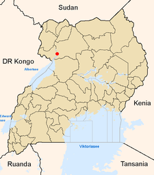
Lage von Pakwach innerhalb Ugandas
Basisdaten Distrikt Nebbi Geographische Lage 2° 27′ N, 31° 30′ O2.4531.5624Koordinaten: 2° 27′ N, 31° 30′ O Fläche ? Einwohnerzahl 17.625 (2002) Bevölkerungsdichte ? Einwohner/km² mittlere Höhe 624 m Niederschlag ? mm/a Zeitzone UTC +3 UN/LOCODE UG ? Telefonvorwahl (+256) – Pakwach ist eine Stadt im Nordwesten Ugandas im Distrikt Nebbi am Westrand des Murchison-Falls-Nationalparks mit 17.625 Einwohnern. Sie liegt am Albert-Nil.
Sie ist Endpunkt der Bahnverbindung der Nordlinie der Uganda Railway nach Tororo und weiter in Richtung Kampala und Nairobi, die allerdings nur für den Güterverkehr genutzt wird. Die wichtigste Fernstraße führt nach Nebbi.
Kategorie:- Ort in Uganda

Wikimedia Foundation.