Peyto Lake

Peyto Lake
Peyto Lake
Peyto Lake-Banff NP-Canada.jpg
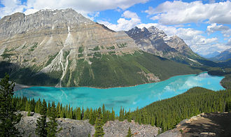
Abfluss Mistaya River → North Saskatchewan River
Größere Städte in der Nähe Banff
Daten
Koordinaten 51° 43′ 25″ N, 116° 31′ 19″ W51.723605555556-116.521805555561880Koordinaten: 51° 43′ 25″ N, 116° 31′ 19″ W
Peyto Lake (Alberta)
Peyto Lake
Höhe über Meeresspiegel 1.880 m
Fläche 5,3 km²f5

Der Peyto Lake ist ein Bergsee im Banff National Park in den kanadischen Rocky Mountains. Er kann über den Icefields Parkway erreicht werden. Der See wird von Gletschern gespeist (darunter der gleichnamige Peyto-Gletscher) und ist aufgrund seiner auffälligen türkisen Farbe in vielen Bildbänden über Kanada abgebildet. Diese wird durch feine Gesteinspartikel verursacht, die im Schmelzwasser mitgeführt werden. Der Peyto Lake wurde nach Bill Peyto benannt, einem bekannten Trapper und Bergführer Ende des 19. Jahrhunderts.

Weblinks

 Commons: Peyto Lake – Sammlung von Bildern, Videos und Audiodateien

Wikimedia Foundation.

Игры ⚽ Поможем написать реферат

Schlagen Sie auch in anderen Wörterbüchern nach:

  • Peyto Lake — Infobox lake lake name = Peyto Lake image lake = Peyto Lake Banff NP Canada.jpg caption lake = Peyto Lake seen from Bow Summit image bathymetry = caption bathymetry = location = Banff National Park, Alberta, Canada coords =… …   Wikipedia

  • Peyto Glacier — is located in Banff National Park, Alberta, Canada, approximately 90 km (56 miles) northwest of the town of Banff, and can be accessed from the Icefields Parkway. Peyto Glacier is an outflow glacier from the Wapta Icefield, which rests along the… …   Wikipedia

  • Peyto — may refer to: *Peyto Lake *Peyto Peak *Peyto Glacier …   Wikipedia

  • Peyto Peak — Infobox Mountain Name = Peyto Peak Photo = Caption = Elevation = m to ft|2980|abbr=yes|precision=0Cite web| author=Peakfinder| url=http://www.rmbooks.com/Peakfinder/peakfinder.ASP?PeakName=peyto+peak| title= Peyto Peak|accessdate= 2007 08 31]… …   Wikipedia

  • Peyto-Gletscher — Der Peyto Gletscher ist ein im Banff Nationalpark (Kanada, Alberta) gelegener Gletscher. Der etwa 12,6 km² große Gletscher geht vom Wapta Eisfeld aus. Er erstreckt sich zwischen 2100 m und 3185 m Höhe über Meeresspiegel. Zuerst wurde der… …   Deutsch Wikipedia

  • Lago Peyto — (Peyto Lake) El lago Peyto, desde el mirador Localización geográfica / administrativa …   Wikipedia Español

  • Lac Peyto — Administration Pays  C …   Wikipédia en Français

  • Bow Lake (Alberta) — Infobox lake lake name = Bow Lake image lake = Bow Lake 2.jpg caption lake = image bathymetry = caption bathymetry = location = Alberta, Canadian Rockies coords = coord|51|40|18|N|116|27|22|W|region:CA AB type:waterbody scale:50000|display=inline …   Wikipedia

  • Hector Lake — Infobox lake lake name = Hector Lake image lake = Hector Lake+Waputik range.jpg caption lake = Hector Lake and Waputik Range seen from the Icefield Parkway image bathymetry = caption bathymetry = location = Alberta s Rockies coords =… …   Wikipedia

  • Bow Lake (Alberta) — Bow Lake Geographische Lage Banff Nationalpark, Alberta, Kanada Abfluss Bow River …   Deutsch Wikipedia

Share the article and excerpts

Direct link
Do a right-click on the link above
and select “Copy Link”