- Marinduque
-
Marinduque Gewässer Sibuyan-See, Pazifischer Ozean Inselgruppe Inselgruppe Luzon Geographische Lage 13° 24′ 0″ N, 121° 57′ 0″ O13.4121.951157Koordinaten: 13° 24′ 0″ N, 121° 57′ 0″ O 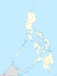

Fläche 915,9 km² Höchste Erhebung Malindig
1.157 mEinwohner 229.636 (1. August 2007[1])
251 Einw./km²Die Insel Marinduque im Norden der Tablas-Straße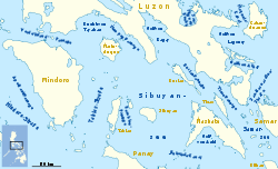
Marinduque ist eine Inselprovinz auf den Philippinen
Die Provinz hat 229.636 Einwohner, verteilt auf 49.956 Haushalte.[2] Marinduque hat eine Fläche von 952,6 km², sie umfasst neben der namengebenden Hauptinsel auch mehrere kleinere Inseln. Sie gehört zum philippinischen Regierungsbezirk MIMARO.
Die Insel Marinduque hat eine Fläche von 915,9 km² und erreicht eine Höhe von 1157 m am aktiven Vulkan Malindig. Sie zählt innerhalb der Philippinen zur Inselgruppe Luzon.
Sie liegt südlich von Luzon, östlich von Mindoro und nördlich der Romblonen. Im Nordwesten grenzt sie an die Tayabas-Bay, im Nordosten an die Mompog-Passage, im Süden an die Tablas-Straße und im Osten an die Sibuyan-See.
Bekannte Persönlichkeiten
Ricardo Jamin Kardinal Vida, emeritierter Erzbischof von Cebu wurde am 6. Februar 1931 im Nordwesten der Insel, in Mogpog geboren.
-

Lage der Provinz Marinduque
Weblinks
 Commons: Marinduque – Sammlung von Bildern, Videos und Audiodateien
Referenzen
- ↑ 2007 Census of Population Marinduque vom 1. August 2007, herausgegeben vom National Statistics Office (NSO)
- ↑ Number of Household by Household Size and City/Municipality, Tabelle 4 zum Zensus 2007, herausgegeben vom National Statistics Office (NSO)
Ilocos-Region: Ilocos Norte | Ilocos Sur | La Union | Pangasinán
Cagayan Valley: Batanes | Cagayan | Isabela | Nueva Vizcaya | Quirino
Central Luzon: Aurora | Bataan | Bulacan | Nueva Ecija | Pampanga | Tarlac | Zambales
CALABARZON: Batangas | Cavite | Laguna | Quezon | Rizal
MIMAROPA: Marinduque | Occidental Mindoro | Oriental Mindoro | Romblon
Bicol-Region: Albay | Camarines Norte | Camarines Sur | Catanduanes | Masbate | Sorsogon
Regierungsbezirk Cordillera: Abra | Apayao | Benguet | Ifugao | Kalinga | Mountain Province
Metro Manila: keine Provinzen
Wikimedia Foundation.
Schlagen Sie auch in anderen Wörterbüchern nach:
Marinduque — (Marinduke, spr. Marängdük), Inselgruppe der Bissayer, s. b. 1) … Pierer's Universal-Lexikon
Marinduque — [marin duke], bergige Insel 150 km südöstlich von Manila, Philippinen, 898 km2; Anbau von Reis (in den Küstenebenen), daneben Mais und Maniok. Nahe der Provinzhauptstadt Boac Abbau von Eisenerzen; Tropfsteinhöhlen … Universal-Lexikon
Marinduque — For other meanings of Marinduque , see Marinduque (disambiguation). Marinduque Province … Wikipedia
Marinduque — Provincia de Marinduque Provincia de Filipinas … Wikipedia Español
Marinduque — 13° 24′ 00″ N 121° 58′ 00″ E / 13.4, 121.96666667 … Wikipédia en Français
Marinduque local elections, 2010 — Marinduque gubernatorial election, 2010 2007 ← May 10, 2010 → 2013 … Wikipedia
Marinduque Airport — Paliparan ng Marinduque Exterior of Marinduque Airport IATA: MRQ – ICAO: RPUW Summary … Wikipedia
Marinduque (disambiguation) — Marinduque may refer to: Marinduque, an island province of the Philippines USC GS Marinduque, a survey ship of the United States Coast and Geodetic Survey in commission from 1905 to 1932 This disambiguation page lists articles associated with the … Wikipedia
Marinduque Academy — is one of the local semi private institutions in Mogpog Marinduque. Its campus consists of: the Main Building, where the Administration offices, library, computer room, band instruments storage, laboratory, and a few classrooms can be found, is… … Wikipedia
Marinduque State College — The official logo of Marinduque State College. Marinduque State College (MSC) is a public college in the Philippines. Contents 1 Campus … Wikipedia
-
Marinduque


18+
© Academic, 2000-2024
- Kontaktieren Sie uns: Unterstützung, Werbung
Wörterbücher Export, schritte mit PHP, Joomla, Drupal, WordPress, MODx.