West Tamar Municipality

West Tamar Municipality
West Tamar
LGATasmania WestTamar.png
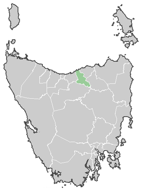
Lage der West Tamar Municipality in Tasmanien
Gliederung
Staat: Australien Australien
Bundesstaat: Flag Australia tasmania.png Tasmanien
Verwaltungssitz: Beaconsfield
Daten und Zahlen
Fläche: 689 km²
Einwohner: 20.814 (2006) [1]
Bevölkerungsdichte: 30 Einwohner je km²
-41.2146.8

Die West Tamar Municipality ist ein lokales Verwaltungsgebiet (LGA) im australischen Bundesstaat Tasmanien. Das Gebiet ist 689 km² groß und hat etwa 21.000 Einwohner.

Die West Tamar Municipality liegt an der zentralen Nordküste der Insel etwa 195 km nördlich der Hauptstadt Hobart. Das Gebiet umfasst 28 Ortsteile und Ortschaften: Badger Head, Beaconsfield, Beauty Point, Blackwall, Bridgenorth, Clarence Point, Deviot, Exeter, Flowery Gully, Franford, Glengarry, Gravelly Beach, Greens Beach, Grindelwald, Holwell, Lanena, Legana, Loira, Kayena, Kelso, Notley Hills, Riverside, Robigana, Rosevears, Rowella, Swan Point, Winkleigh und York Town[2]. Der Sitz des Councils befindet sich in Beaconsfield in der Nordhälfte der LGA, wo etwa 1200 Einwohner leben.[3]

Verwaltung

Der West Tamar Council hat neun Mitglieder. Der Mayor (Bürgermeister), sein Deputy (Stellvertreter) und sieben Councillor werden direkt von den Bewohnern der LGA gewählt. West Tamar ist nicht in Bezirke untergliedert.

Quellen

  1. Australian Bureau of Statistics (25. Oktober 2007): West Tamar (LGA) (Englisch). 2006 Census QuickStats. Abgerufen am 6. April 2010.
  2. Localities by Council, Local Government Association of Tasmania
  3. Australian Bureau of Statistics (25. Oktober 2007): Beaconsfield (State Suburb) (Englisch). 2006 Census QuickStats. Abgerufen am 23. März 2010.

Weblinks


Wikimedia Foundation.

Игры ⚽ Нужна курсовая?

Schlagen Sie auch in anderen Wörterbüchern nach:

  • Legana, Tasmania — Infobox Australian Place | type = town name = Legana state = tas caption = postcode = 7277 pop = 2,273 (2006) poprank = est = timezone = AEST utc = +10 timezone dst= AEDT utc dst = +11 lga = West Tamar Council stategov = Bass fedgov = Bass… …   Wikipedia

  • Blackwall (Tasmanien) — Blackwall Staat: Australien Bundesstaat …   Deutsch Wikipedia

  • Local Government Areas of Tasmania — Local Government Areas of Tasmania, Australia This article also includes lists of towns, suburbs and localities of Tasmania.Hobart area councilsBrighton Council*Hobart suburbs: **Bridgewater Gagebrook Old Beach *Brighton *Pontville *Tea TreeCity… …   Wikipedia

  • City of Launceston — Tasmania City of Launceston Population: 65,8 …   Wikipedia

  • City of Clarence — Tasmania The City of Clarence Population: 52,935 …   Wikipedia

  • Beaconsfield, Tasmania — Infobox Australian Place | type = town name = Beaconsfield state = tas caption = Location of Beaconsfield lga = West Tamar Council postcode = 7270 est = pop = 1,007 elevation= maxtemp = mintemp = rainfall = stategov = Lyons fedgov = Lyons dist1 …   Wikipedia

  • Beauty Point, Tasmania — Infobox Australian Place | type = town name = Beauty Point state = tas caption = lga = West Tamar Council postcode = 7270 est = pop = 1,153 elevation= maxtemp = mintemp = rainfall = stategov = Lyons fedgov = Lyons dist1 = 244 dir1 = N location1=… …   Wikipedia

  • George Town, Tasmania — Infobox Australian Place | type = town name = George Town state = tas caption = postcode = 7253 pop = 6,527 (2006) cite web|url=http://www.abs.gov.au/AUSSTATS/abs@.nsf/DetailsPage/2016.02001?OpenDocument|title=Selected Characteristics for Urban… …   Wikipedia

  • Kingborough Council — Tasmania Kingborough Council Population: 34 …   Wikipedia

  • City of Glenorchy — Tasmania Population: 44,716 …   Wikipedia

Share the article and excerpts

Direct link
Do a right-click on the link above
and select “Copy Link”