Cuvier Island

Cuvier Island

Vorlage:Infobox Insel/Wartung/Bild fehltVorlage:Infobox Insel/Wartung/Fläche fehltVorlage:Infobox Insel/Wartung/Höhe fehlt

Cuvier Island
Gewässer Pazifischer Ozean
Geographische Lage 36° 26′ 0″ S, 175° 46′ 0″ O-36.433333333333175.76666666667Koordinaten: 36° 26′ 0″ S, 175° 46′ 0″ O
Lage von Cuvier Island
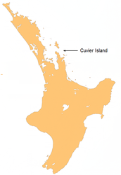
Einwohner (unbewohnt)

Cuvier Island ist eine kleine Insel vor der Ostküste der Nordinsel Neuseelands. Sie liegt am zum Meer führenden Ende des Colville Channel, 15 km nördlich der Mercury Islands und etwa 23 km südöstlich von Great Barrier Island. Die Insel ist ein Schutzgebiet, das vom Department of Conservation verwaltet wird und Teil eines Projekts zur Eliminierung nichtheimischer Säuger und der Wiederherstellung des ursprünglichen Ökosystems auf Neuseeländischen Inseln ist.[1].

Leuchtturm

Auf der Insel befindet sich ein Leuchtturm, Cuvier Island Lighthouse[2]. Er wurde 1889 erbaut und in Betrieb genommen. 1982 wurde er automatisiert und wird seitdem vom Hauptquartier des Betreibers und Eigentümers, Maritime New Zealand, in Wellington gesteuert. Das Leuchtfeuer hat eine Höhe von 119 m über dem Meer und eine Reichweite von 35 km. Sein Licht blinkt weiss alle 15 Sekunden.

Der Turm selbst ist eine 15m hohe, zylindrische Gusseisenkonstruktion und war bei seinem Bau 1889 der erste gusseiserne Leuchtturm Neuseelands.

Einzelnachweise

  1. Website des Department of Conservation zu Cuvier Island
  2. Seite zum Cuvier Island Lighthouse

Wikimedia Foundation.

Игры ⚽ Нужна курсовая?

Schlagen Sie auch in anderen Wörterbüchern nach:

  • Cuvier Island — Repanga (Māori) Location map of Cuvier Island. Geography Coordinates …   Wikipedia

  • Cuvier Island Lighthouse — Location Cuvier Island, North Island, New Zealand Coordinates 36°26′S 175°47′E /  …   Wikipedia

  • Cuvier — may refer to: Georges Cuvier, (1769–1832), French naturalist and zoologist Frédéric Cuvier (1773–1838), French zoologist Cuvier, Jura, a commune of the Jura département in France Cuvier Island, a lighthouse island in the Hauraki Gulf, New Zealand …   Wikipedia

  • Cuvier — ist der Name folgender geographischer Objekte: Cuvier Island, kleine Insel vor der Ostküste der Nordinsel Neuseelands Cuvier, Mondkrater von 75 km Durchmesser, siehe Liste der Krater des Erdmondes/C Cuvier (Jura), eine Gemeinde im französischen… …   Deutsch Wikipedia

  • Island restoration — The ecological restoration of islands, or island restoration, is the application of the principles of ecological restoration to islands and island groups. Islands, due to their isolation, are home to many of the world s endemic species, as well… …   Wikipedia

  • Cuvier Press Club Building — Cuvier Press Club U.S. National Register of Historic Places …   Wikipedia

  • Moutohora Island — Whale Island von Süden aus gesehen Whale Island (Māori: Moutohora) ist eine kleine Insel vor der Küste der Bay of Plenty in der gleichnamigen Region an Neuseelands Nordinsel. Sie liegt etwa 12 km nördlich der Stadt Whakatane. Die Insel erhielt… …   Deutsch Wikipedia

  • Île Cuvier — Catégorie UICN Ia (réserve naturelle intégrale) Identifiant 304027 Pays   …   Wikipédia en Français

  • Moutohora Island — Moutohora Island, Whale Island Moutohorā (Māori) Moutohora Island seen from the south …   Wikipedia

  • Whale Island, New Zealand — Infobox Mountain Name= Whale Island Photo=WhaleIsland2006.jpg Caption= Whale Island seen from the south. Elevation= Convert|354|m|ft|0|abbr=on Location=Bay of Plenty, North Island, New Zealand Range= Prominence = Convert|354|m|ft|0|abbr=on… …   Wikipedia

Share the article and excerpts

Direct link
Do a right-click on the link above
and select “Copy Link”