- Dimataling
-
Municipality of Dimataling Lage von Dimataling in der Provinz Zamboanga del Sur 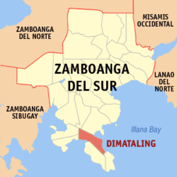
Basisdaten Bezirk: Zamboanga Peninsula Provinz: Zamboanga del Sur Barangays: 24 Distrikt: 2. Distrikt von Zamboanga del Sur PSGC: 097305000 Einkommensklasse: 4. Einkommensklasse Haushalte: 4949 Zensus 1. Mai 2000Einwohnerzahl: 26.902 Zensus 1. August 2007Koordinaten: 7° 32′ N, 123° 22′ O7.5333333333333123.36666666667Koordinaten: 7° 32′ N, 123° 22′ O Postleitzahl: 7032 Bürgermeister: Haniel Capangpangan Baya Offizielle Webpräsenz: www.zds-dimataling.gov.ph Geographische Lage auf den Philippinen 

Dimataling Dimataling ist eine philippinische Stadtgemeinde in der Provinz Zamboanga del Sur. Nach dem Zensus vom 1. Mai 2000 hat sie 25.843 Einwohner in 4949 Haushalten.
Baranggays
Dimataling ist politisch in 24 Baranggays unterteilt.
- Bacayawan
- Baha
- Balanagan
- Baluno
- Binuay
- Buburay
- Grap
- Josefina
- Kagawasan
- Lalab
- Libertad
- Magahis
- Mahayag
- Mercedes
- Poblacion
- Saloagan
- San Roque
- Sugbay Uno
- Sumbato
- Sumpot
- Tinggabulong
- Tiniguangan
- Tipangi
- Upper Ludiong
Städte und Stadtgemeinden in der Provinz Zamboanga del SurStädte: Pagadian City
Stadtgemeinden: Aurora | Bayog | Dimataling | Dinas | Dumalinao | Dumingag | Guipos | Josefina | Kumalarang | Labangan | Lakewood | Lapuyan | Mahayag | Margosatubig | Midsalip | Molave | Pitogo | Ramon Magsaysay | San Miguel | San Pablo | Sominot | Tabina | Tambulig | Tigbao | Tukuran | Vincenzo A. Sagun
Wikimedia Foundation.
Schlagen Sie auch in anderen Wörterbüchern nach:
Dimataling — Original name in latin Dimataling Name in other language Dimatalin, Dimataling State code PH Continent/City Asia/Manila longitude 7.5344 latitude 123.3738 altitude 8 Population 4272 Date 2010 08 14 … Cities with a population over 1000 database
Dimataling, Zamboanga del Sur — Dimataling Municipality Map of Zamboanga del Sur showing the location of Dimataling … Wikipedia
Margosatubig, Zamboanga del Sur — Margosatubig Margos Municipality Map of Zam … Wikipedia
PH-ZAS — Lage von Zamboanga del Sur Die Provinz Zamboanga del Sur besetzt die südöstliche Ecke der Halbinsel Zamboanga. Diese ist ein Ausläufer der Insel Mindanao, der größten Insel im Süden der Philippinen. Die Hauptstadt der Provinz ist Pagadian City.… … Deutsch Wikipedia
Dinas, Zamboanga del Sur — Dinas Municipality Coordinates … Wikipedia
Dumalinao, Zamboanga del Sur — Dumalinao Municipality Map of Zamboanga del Sur showing the location of Dumalinao … Wikipedia
Dumingag, Zamboanga del Sur — Dumingag Municipality Map of Zamboanga del Sur showing the location of Dumingag … Wikipedia
Mahayag, Zamboanga del Sur — Mahayag Municipality Town hall … Wikipedia
Molave, Zamboanga del Sur — Molave redirects here. This can also refer to the wood of Vitex cofassus and Vitex parviflora. Molave Municipality … Wikipedia
Midsalip, Zamboanga del Sur — Midsalip Municipality Map of Zamboanga del Sur showing the location of Midsalip … Wikipedia
Dimataling


18+
© Academic, 2000-2024
- Kontaktieren Sie uns: Unterstützung, Werbung
Wörterbücher Export, schritte mit PHP, Joomla, Drupal, WordPress, MODx.