- East Belfast
-
East Belfast (irisch Béal Feirste Thoir) ist ein östlich der Innenstadt angrenzender Stadtteil von Belfast, der räumlich durch den Lagan abgetrennt ist. Der Stadtteil, der einen von vier Belfaster Wahlkreisen bildet und von 1979 bis 2010 von Peter Robinson (DUP) im britischen Parlament vertreten wurde, zählt 79.621 Einwohner (2001).
Besonders entlang der Waterfront wurde in den letzten Jahren eine Vielzahl von Bauprojekten in Angriff genommen und zum Teil bereits fertiggestellt: So etwa das Odyssey Center, welches eine Arena für Eishockey und Konzerte, ein IMAX-Kino sowie ein interaktives Museum einschließt.
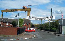 Die Harland & Wulff Kräne - Wahrzeichen von East Belfast
 Wandbild an der Newtownards Road
Dominiert wird die Szenerie East Belfasts durch die beiden Kräne der Harland & Wolff Werft, im Volksmund Samson und Goliath genannt, die als die höchsten freistehenden Kräne der Welt gelten. Von der Werft ausgehend schließen sich entlang des Belfast Lough und der Verlängerung der Autobahn M3 (Sydenham By-Pass) in Richtung Bangor weitläufige Industriegebiete an. In der Nähe befindet sich auch der Belfast City Airport.
Südlich der Autobahn und der Belfast mit Bangor verbindenden Eisenbahnlinie liegt das Stadion The Oval des Belfaster Fußballvereins Glentoran FC.
East Belfast wird überwiegend von Protestanten bewohnt, etwa 85% der Einwohner East Belfasts rechnen sich diesem Bevölkerungsteil zu, gegenüber knapp 10% auf katholischer Seite. Diese Übermacht macht sich insbesondere durch Wandbilder (Murals) entlang der Newtownards Road – der Hauptschlagader East Belfasts – bemerkbar, deren westliches Ende von der trostlos wirkenden Wohnblocksiedlung Ballymacarrett geprägt wird. Aber auch in den östlich und südöstlich angrenzenden Gemeinden Dundonald und Castlereagh (beide Grafschaft Down) stellen die Protestanten die Mehrheit. Als Zentrum East Belfasts gilt das Connswater Shopping Centre.
Unmittelbar an den Lagan angrenzend befindet sich Short Strand, eine südlich der Newtownards Road gelegene und fast ausschließlich von Katholiken bewohnte Enklave, welche in der Vergangenheit häufig im Mittelpunkt von Auseinandersetzungen zwischen beiden rivalisierenden Bevölkerungsgruppen stand.
Sehenswert ist das in einer ausgedehnte Parkanlage gelegene Stormont Castle im Bezirk Belmont, am östlichen Ende der Newtownards Road. Hier befindet sich der Sitz der nordirischen Regionalregierung und des nordirischen Regionalparlamentes (Northern Irish Assembly).
Weblinks
54.6059-5.8907Koordinaten: 54° 36′ N, 5° 53′ WKategorien:- Ort in Nordirland
- Belfast


Wikimedia Foundation.