- East Caicos
-
East Caicos Position der Insel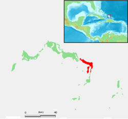
Gewässer Atlantischer Ozean Inselgruppe Caicos-Inseln Geographische Lage 21° 42′ N, 71° 30′ W21.7025-71.49805555555648Koordinaten: 21° 42′ N, 71° 30′ W 

Länge 13 km Breite 7 km Fläche 90 km² Höchste Erhebung Flamingo Hill
48 mEinwohner (unbewohnt) Hauptort Jacksonville (historisch) East Caicos ist die nordöstlichste Insel der Caicos-Inseln und gehört zum britischen Überseegebiet der Turks- und Caicosinseln.
Die Insel ist von Middle Caicos und South Caicos durch schmale Meeresarme getrennt, welche jeweils nur mit kleinen Booten befahrbar sind. Die Fläche von East Caicos beträgt etwa 90 km². Hinzu kommen ausgedehnte Sumpf- und Wattgebiete im Süden und Südosten, so dass die Landfläche bei Ebbe erheblich größer ist (gesamt ca. 182 km²). Auf East Caicos liegt der Flamingo Hill, mit einer Höhe von 48 Metern der höchste „Berg“ der Turks- und Caicosinseln.
East Caicos ist seit über 100 Jahren unbewohnt. Früher (bis etwa Anfang 1900) befanden sich hier große Sisalplantagen und Wohnstätten der Landarbeiter. Vom damaligen Hauptort der Insel Jacksonville, gelegen an der Nordküste, sind heute nur noch wenige Ruinen vorhanden.
Weblinks
Literatur
- H. E. Sadler, Marjorie Sadler, Karen Collins: Turks Islands Landfall. A History of the Turks & Caicos Islands. Marjorie E. Sadler, Grand Turk - Turks and Caicos Islands 1997, ISBN 976-8138-62-9.

Turks-Inseln: Grand Turk | Salt Cay | Cotton Cay | East Cay | Gibbs Cay
Caicos-Inseln: West Caicos | Providenciales | Water Cay | Pine Cay | Stubbs Cay | Fort George Cay | Dellis Cay | Parrot Cay | North Caicos | Middle Caicos | East Caicos | South Caicos | Long Cay | Ambergris Cays
Wikimedia Foundation.
Schlagen Sie auch in anderen Wörterbüchern nach:
East Caicos — is the fourth largest island in the Turks and Caicos Islands. To the west, it is separated from Middle Caicos by Lorimer Creek, a narrow passage that can accommodate only small boats. To the south is South Caicos.East Caicos has an area of 90.6… … Wikipedia
East Caicos — Géographie Pays Royaume Uni Archipel Îles Turques et Caïques … Wikipédia en Français
Caicos-Inseln — Karte der Turks und Caicosinseln Gewässer Atlantischer Ozean … Deutsch Wikipedia
Caicos del Este — Saltar a navegación, búsqueda La isla Caicos del Este (East Caicos) es la cuarta mayor en el territorio británico dependiente de Islas Turcas y Caicos. Pertenece al archipiélago de las Islas Caicos. Hacia el oeste está separada de la isla Caicos… … Wikipedia Español
East — Saltar a navegación, búsqueda East (en inglés: Este) hace referencia a varios artículos: Contenido 1 Comunicaciones 2 Lugares 2.1 Europa 2.2 América … Wikipedia Español
Caicos — ► Grupo de islas británicas en el extremo SE del archipiélago de las Bahamas; 4 315 h. Las principales son: North Caicos, South Caicos, Middle Caicos, East Caicos, West Caicos y Providenciales. (V. Turks.) … Enciclopedia Universal
East Caribbean dollar — 2002 1 dollar coin ISO 4217 code XCD User(s) … Wikipedia
Turks and Caicos Islands — Turks and Caicos Islands … Wikipedia
Grand Caicos — Middle Caicos (Grand Caicos) Position der Insel Gewässer Atlantischer Ozean Inselgruppe … Deutsch Wikipedia
Turks and Caicos Islands — /terrks; kuy kohs, kay / two groups of islands in the SE Bahamas: British crown colonies. 5675; ab. 166 sq. mi. (430 sq. km). Cap.: Grand Turk. * * * Turks and Caicos Islands Introduction Turks and Caicos Islands Background: The islands were part … Universalium
East Caicos


18+
© Academic, 2000-2024
- Kontaktieren Sie uns: Unterstützung, Werbung
Wörterbücher Export, schritte mit PHP, Joomla, Drupal, WordPress, MODx.