- Jamindan
-
Municipality of Jamindan Lage von Jamindan in der Provinz Capiz 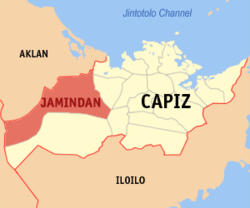
Basisdaten Bezirk: Western Visayas Provinz: Capiz Barangays: 30 Distrikt: 2. Distrikt von Capiz PSGC: 061906000 Einkommensklasse: 3. Einkommensklasse Haushalte: 6850 Zensus 1. Mai 2000Einwohnerzahl: 34.831 Zensus 1. August 2007Koordinaten: 11° 24′ N, 122° 30′ O11.4122.5Koordinaten: 11° 24′ N, 122° 30′ O Postleitzahl: 5808 Geographische Lage auf den Philippinen 

Jamindan Jamindan ist eine philippinische Stadtgemeinde in der Provinz Capiz. Nach dem Zensus vom 1. Mai 2000 hat sie 33.966 Einwohner in 6.850 Haushalten.
Baranggays
Jamindan ist politisch in 30 Baranggays unterteilt.
- Agambulong
- Agbun-od
- Agcagay
- Aglibacao
- Agloloway
- Bayebaye
- Caridad
- Esperanza
- Fe
- Ganzon
- Guintas
- Igang
- Jaena Norte
- Jaena Sur
- Jagnaya
- Lapaz
- Linambasan
- Lucero
- Maantol
- Masgrau
- Milan
- Molet
- Pangabat
- Pangabuan
- Pasol-o
- Poblacion
- San Jose
- San Juan
- San Vicente
- Santo Rosario
Städte und Stadtgemeinden in der Provinz CapizStädte: Roxas City
Stadtgemeinden: Cuartero | Dao | Dumalag | Dumarao | Ivisan | Jamindan | Ma-ayon | Mambusao | Panay | Panitan | Pilar | Pontevedra | President Roxas | Sapi-an | Sigma | Tapaz
Wikimedia Foundation.
Schlagen Sie auch in anderen Wörterbüchern nach:
Jamindan — Original name in latin Jamindan Name in other language Jamindan State code PH Continent/City Asia/Manila longitude 11.4089 latitude 122.5095 altitude 36 Population 2162 Date 2011 07 31 … Cities with a population over 1000 database
Jamindan, Capiz — Jamindan is a 4th class municipality in the province of Capiz, Philippines. According to the 2000 census, it has a population of 33,966 people in 6,850 households.BarangaysJamindan is politically subdivided into 30 barangays. * Agambulong * Agbun … Wikipedia
PH-CAP — Karte der Philippinen mit der Lage von Capiz Karte der Insel Panay/Philippinen Capiz ist eine Provinz auf der Insel Panay, die zu dem Inselstaat der Philippinen gehört … Deutsch Wikipedia
Geography of the Philippines — Country geography name = the Philippines continent = Asia region = Southeast Asia coordinates = 13°00 N 122°00 E area ranking = 72nd km area = 300000 percent land = 99.38 km coastline = 36289 borders = None northernmost point = Y Ami island… … Wikipedia
Clark Air Base — For the civil use of the land holdings after December 1991, see Clark Freeport Zone. For the civil use of the airfield after December 1991, see Diosdado Macapagal International Airport. For other air fields, see Clark Field (disambiguation).… … Wikipedia
Cuartero, Capiz — Map of Capiz showing the location of Cuartero Cuartero is a 4th class municipality in the province of Capiz, Philippines. According to the 2000 census, it has a population of 24,286 people in 4,681 households. Barangays Cuartero is politically… … Wikipedia
Dao, Capiz — Map of Capiz showing the location of Dao Dao is a 4th class municipality in the province of Capiz, Philippines. According to the 2000 census, it has a population of 30,623 people in 5,921 households. Contents 1 … Wikipedia
Dumalag, Capiz — Map of Capiz showing the location of Dumalag Dumalag is a 4th class municipality in the province of Capiz, Philippines. According to the 2000 census, it has a population of 25,920 people in 5,375 households. Barangays Dumalag is politically… … Wikipedia
Dumarao, Capiz — Map of Capiz showing the location of Dumarao Dumarao is a 3rd class municipality in the province of Capiz, Philippines. According to the 2000 census, it has a population of 40,303 people in 7,993 households. It was originally founded in 1580 and… … Wikipedia
Mambusao, Capiz — Map of Capiz showing the location of Mambusao Mambusao is a 1st class municipality in the province of Capiz, Philippines. According to the 2000 census, it has a population of 36,793 people in 7,421 households. Mambusao is the home of the… … Wikipedia
Jamindan


18+
© Academic, 2000-2024
- Kontaktieren Sie uns: Unterstützung, Werbung
Wörterbücher Export, schritte mit PHP, Joomla, Drupal, WordPress, MODx.