- Liste der Countys in Maryland
-
Der US-Bundesstaat Maryland ist in 24 Countys unterteilt. Die Stadt Baltimore gehört zu keinem County, wird aber mitgerechnet, weil sie in den meisten Bereichen die identischen Funktionen ausführt. Viele der Countys wurden nach Mitglieder des Ordens von Baron Baltimore benannt. Diese besaßen die Kolonie Maryland von 1634 bis 1771.
Die offizielle Abkürzung des Staates Maryland lautet MD, der FIPS-Code ist 24[1].
Der FIPS-Code für jedes einzelne County beginnt also stets mit 24, an die jeweils eine dreistellige Zahl angehängt wird.
Die Angaben der Bevölkerungszahlen basieren auf der Volkszählung im Jahr 2010.
County FIPS Code
[2]Hauptort (County Seat)
[3][4]Gegründet Ursprung Namensherkunft Bevölkerung
[4][5]Fläche
[4][5]Karte Allegany County 001 Cumberland 1789 Gebildet aus Washington County. Aus dem Wort oolikhanna der Lenapi-Indianer, steht für „Schöner Fluss“ 75.087 1.114 km² (430 sq mi) 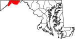
Anne Arundel County 003 Annapolis 1650 Gebildet aus Teilen von St. Mary's County. Anne Arundell war der Mädchenname der Frau von Cæcilius Calvert, 2nd Baron Baltimore. Zwischen 1654 und 1658 bekannt als Providence County unter Puritanischen Siedlern (Providence = „Vorsehung“) 537.656 1.523 km² (588 sq mi) 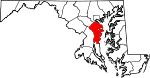
Baltimore County 005 Towson 1659 Aus unorganisiertem Gebiet gebildet Cæcilius Calvert, 2nd Baron Baltimore, erster Besitzer der Kolonie Maryland 805.029 1.766 km² (682 sq mi) 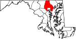
Baltimore City 510 Baltimore City 1851 Founded in 1729. Detached in 1851 from Baltimore County Cæcilius Calvert, 2nd Baron Baltimore, erster Besitzer der Kolonie Maryland 620.961 238 km² (92 sq mi) 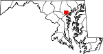
Calvert County 009 Prince Frederick 1654 Gegründet als Patuxent County aus unorganisiertem Gebiet, umbenannt in Calvert County 1658 Calvert ist der Familienname der Barons von Balitmore 88.737 894 km² (345 sq mi) 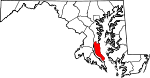
Caroline County 011 Denton 1773 Dorchester County und Queen Anne's County Lady Caroline Eden, Tochter von Charles Calvert, 5th Baron Baltimore 33.066 844 km² (326 sq mi) 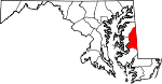
Carroll County 013 Westminster 1837 Baltimore County und Frederick County Charles Carroll of Carrollton, Repräsentant im Continental Congress und Unterzeichner der Declaration of Independence 167.134 1.171 km² (452 sq mi) 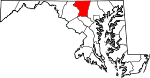
Cecil County 015 Elkton 1672 Baltimore County und Kent County Cecil ist ein anglizierter Name von Cæcilius Calvert, 2nd Baron Baltimore 101.108 1.083 km² (418 sq mi) 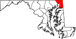
Charles County 017 La Plata 1658 Aus unorganisiertem Gebiet Charles Calvert, 3rd Baron Baltimore, 146.551 1.665 km² (643 sq mi) 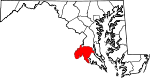
Dorchester County 019 Cambridge 1668 Aus unorganisiertem Gebiet Dorchester in Dorset, England; Der Earl of Dorset war ein Freund der Familie Calvert 32.618 2.546 km² (983 sq mi) 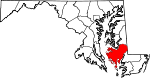
Frederick County 021 Frederick 1748 Prince George's County Frederick Calvert, 6th Baron Baltimore, letzter Besitzer der Kolonie Maryland 233.385 1.728 km² (667 sq mi) 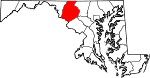
Garrett County 023 Oakland 1872 Allegany County John Work Garrett, Präsident der Baltimore and Ohio Railroad 30,097 1.699 km² (656 sq mi) 
Harford County 025 Bel Air 1773 Baltimore County Henry Harford, Unehelicher Sohn von Frederick Calvert, 6th Baron Baltimore 244.826 1.365 km² (527 sq mi) 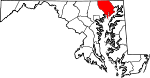
Howard County 027 Ellicott City 1851 Anne Arundel County und Baltimore County John Eager Howard, Soldat und Gouverneur von Maryland 287.085 658 km² (254 sq mi) 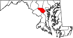
Kent County 029 Chestertown 1642 Aus unorganisiertem Gebiet Kent in England 20.197 1.072 km² (414 sq mi) 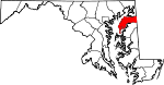
Montgomery County 031 Rockville 1776 From part of Frederick County Richard Montgomery, General im Unabhängigkeitskrieg 971.777 1.313 km² (507 sq mi) 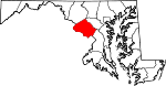
Prince George's County 033 Upper Marlboro 1696 Calvert County und Charles County Georg von Dänemark und Norwegen, Mann von Königin Anna von Großbirtannien 863.420 1.290 km² (498 sq mi) 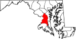
Queen Anne's County 035 Centreville 1706 Talbot County Anne Stuart, Königin von Großbitannien 47.798 1.321 km² (510 sq mi) 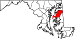
Saint Mary's County 037 Leonardtown 1637 Aus unorganisiertem Gebiet. Hieß Potomac County zwischen 1654 und 1658. Maria, die Mutter Jesu, erstes in einer Kolonie Englands errichtetes County, sollte ein Hafen für Katholiken werden 105.151 1.582 km² (611 sq mi) 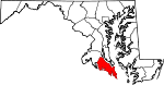
Somerset County 039 Princess Anne 1666 Aus unorganisiertem Gebiet. Mary, Lady Somerset, Verwandte von Cæcilius Calvert, 2nd Baron Baltimore 26.470 1.582 km² (611 sq mi) 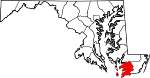
Talbot County 041 Easton 1662 Kent County Grace, Lady Talbot, Schwester von Cæcilius Calvert, 2nd Baron Baltimore 37.782 1.235 km² (477 sq mi) 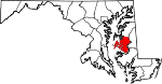
Washington County 043 Hagerstown 1776 Frederick County George Washington, erster Präsident der Vereinigten Staaten 147.430 1.212 km² (468 sq mi) 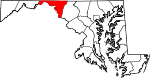
Wicomico County 045 Salisbury 1867 Somerset County und Worcester County Wicomico River; in Lenape, bedeutet wicko mekee „Ein Ort, wo Häuser gebaut werden“, also eine Siedlung 98.733 1.036 km² (400 sq mi) 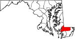
Worcester County 047 Snow Hill 1742 Somerset County Mary Arundell, die Frau von Sir John Somerset, Sohn von 1st Marquess of Worcester, und Schwester von Anne Arundell, Frau von Cæcilius Calvert, 2nd Baron Baltimore 51.454 1.800 km² (695 sq mi) 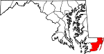
Einzelnachweise
- ↑ FIPS-Codes von Maryland
- ↑ EPA County FIPS Code Listing. EPA.gov. Abgerufen am 23. Februar 2008.
- ↑ Counties. Maryland Manual Online. Abgerufen am 24. Juni 2007.
- ↑ a b c National Association of Counties: NACo - Find a county. Abgerufen am 30. April 2008.
- ↑ a b Maryland QuickFacts. U.S. Census Bureau. Abgerufen am 29. Juni 2011.
Alabama | Alaska | Arizona | Arkansas | Colorado | Connecticut | Delaware | Florida | Georgia | Hawaii | Idaho | Illinois | Indiana | Iowa | Kalifornien | Kansas | Kentucky | Louisiana | Maine | Maryland | Massachusetts | Michigan | Minnesota | Mississippi | Missouri | Montana | Nebraska | Nevada | New Hampshire | New Jersey | New Mexico | New York | North Carolina | North Dakota | Ohio | Oklahoma | Oregon | Pennsylvania | Rhode Island | South Carolina | South Dakota | Tennessee | Texas | Utah | Vermont | Virginia | Washington | West Virginia | Wisconsin | Wyoming
Wikimedia Foundation.
Schlagen Sie auch in anderen Wörterbüchern nach:
Liste der Städte in Maryland — Karte von Maryland Marylands Hauptstadt Annapolis … Deutsch Wikipedia
Liste der Countys auf Hawaii — Counties Hawaiis Der US Bundesstaat Hawaii ist in 5 Countys unterteilt: Lage County Fläche Einwohner 1. Juli 2005 Verwaltungs sitz Einwohner 1. April 2000 Bereich … Deutsch Wikipedia
Liste der Countys in Lousiana — Parishes in Louisiana Der US Bundesstaat Louisiana in den Vereinigten Staaten ist in 64 Parishes unterteilt. Ihr Status entspricht dem der Countys in den anderen Bundesstaaten. Acadia … Deutsch Wikipedia
Liste der Countys in Nevada — Der US Bundesstaat Nevada ist in 17 Countys unterteilt. Die Hauptstadt Carson City ist eine unabhängige Stadt, zählt jedoch nach dem US Census Bureau als County. County Einwohner (1. Juli 2006) Verwaltungssitz Einwohner (1. Juli 2005) Carson City … Deutsch Wikipedia
Liste der Countys in Montana — LN FH LK SA MN MS … Deutsch Wikipedia
Liste der Countys in Kentucky — Boone Ken ton Camp bell Pend leton Bracken Robertson … Deutsch Wikipedia
Liste der Countys in Michigan — Keweenaw Houghton Ontonagon Gogebic Iron Baraga … Deutsch Wikipedia
Liste der Counties in North Carolina — Der US Bundesstaat North Carolina ist in 100 Countys unterteilt: Alamance County Alexander County Alleghany County Anson County Ashe County Avery County Beaufort County Bertie County … Deutsch Wikipedia
Liste der Grafschaften in Neumexiko — Der US Bundesstaat New Mexico ist in 33 Countys unterteilt. County Einwohner 1. Juli 2005 Verwaltungssitz Einwohner 1. Juli 2004 Bernalillo 603.562 Albuquerque 484.246 Catron 3.409 Reserve 345 Chav … Deutsch Wikipedia
Liste der Landkreise in North Carolina — Der US Bundesstaat North Carolina ist in 100 Countys unterteilt: Alamance County Alexander County Alleghany County Anson County Ashe County Avery County Beaufort County Bertie County … Deutsch Wikipedia
Liste der Countys in Maryland


18+
© Academic, 2000-2024
- Kontaktieren Sie uns: Unterstützung, Werbung
Wörterbücher Export, schritte mit PHP, Joomla, Drupal, WordPress, MODx.