- Ouachita County
-
Verwaltung US-Bundesstaat: Arkansas Verwaltungssitz: Camden Adresse des
Verwaltungssitzes:County Courthouse
P.O. Box 644
Camden, AR 71711-0644Gründung: 29. November 1842 Gebildet aus: Union County Vorwahl: 001 870 Demographie Einwohner: 26.120 (2010) Bevölkerungsdichte: 13,8 Einwohner/km² Geographie Fläche gesamt: 1.916 km² Wasserfläche: 19 km² Karte 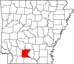
Das Ouachita County[2] ist ein County im US-amerikanischen Bundesstaat Arkansas. Bei der Volkszählung im Jahr 2010 hatte das County 26.120 Einwohner und eine Bevölkerungsdichte von 13,8 Einwohnern pro Quadratkilometer. Der Verwaltungssitz (County Seat) ist Camden.
Inhaltsverzeichnis
Geografie
Das County liegt im mittleren Süden von Arkansas, ist im Süden etwa 60 km von Louisiana entfernt und hat eine Fläche von 1.916 Quadratkilometern, wovon 19 Quadratkilometer Wasserfläche sind. Es grenzt an folgende Countys:
Clark County Dallas County Nevada County 
Calhoun County Columbia County Union County Geschichte
Das Ouachita County wurde am 29. November 1842[3] aus Teilen des Union County als 45. County in Arkansas gebildet. Benannt wurde es nach dem Ouachita River, der das County durchfließt.
Das erste Schulgebäude wurde 1871 errichtet. Bis 1880 wurde der hauptsächliche Personen- und Warentransport durch die Dampfschifffahrt erledigt. Hauptabnehmer der produzierten Waren waren Baton Rouge und New Orleans. Nach 1880 kam durch die Reader Railroad, damals auch bekannt als die Possum Trot Line, die Eisenbahn in das County. Die Zugverbindung förderte das Entstehen neuer Staädte und Gemeinden.
1907 begann Garland Anthony mit einem kleinen Sägewerk, aus dem bis heute die Firma Anthony Timberlands entstanden ist. 1928 kam die Produktion von Papier hinzu, der heutigen International Paper Company.
Historische Objekte
- Auf der US Route 79B befindet sich die historisch relevante Ben Laney Bridge.
Demografische Daten
Historische Einwohnerzahlen Census Einwohner ± in % 1850 9591 — 1860 12.936 30 % 1870 12.975 0,3 % 1880 11.758 -9 % 1890 17.033 40 % 1900 20.892 20 % 1910 21.774 4 % 1920 20.636 -5 % 1930 29.890 40 % 1940 31.151 4 % 1950 33.051 6 % 1960 31.641 -4 % 1970 30.896 -2 % 1980 30.541 -1 % 1990 30.574 0,1 % 2000 28.790 -6 % 2010 26.120 -9 % 1850–1890[4] 1900–1990[5] 2010[6] Nach der Volkszählung im Jahr 2010 lebten im Ouachita County 26.120 Menschen in 11.019 Haushalten. Die Bevölkerungsdichte betrug .. Einwohner pro Quadratkilometer.
Ethnisch betrachtet setzte sich die Bevölkerung zusammen aus 57,0 Prozent Weißen, 40,1 Prozent Afroamerikanern, 0,3 Prozent amerikanischen Ureinwohnern, 0,4 Prozent Asiaten sowie aus anderen ethnischen Gruppen; 1,6 Prozent stammten von zwei oder mehr Ethnien ab. Unabhängig von der ethnischen Zugehörigkeit waren 1,6 Prozent der Bevölkerung spanischer oder lateinamerikanischer Abstammung.
In den 11.019 Haushalten lebten statistisch je 2,30 Personen.
23,4 Prozent der Bevölkerung waren unter 18 Jahre alt, 59,4 Prozent waren zwischen 19 und 64 und 17,2 Prozent waren 65 Jahre oder älter. 52,4 Prozent der Bevölkerung war weiblich.
Das jährliche Durchschnittseinkommen eines Haushalts lag bei 32.393 USD. Das Pro - Kopf - Einkommen betrug 18.072 USD. 21,9 Prozent der Einwohner lebten unterhalb der Armutsgrenze.[7]
Städte und Gemeinden
- Bearden
- Camden
- Chidester
- East Camden
- Louann
- Reader1
- Stephens
1- teilweise im Nevada County
Einzelnachweise
- ↑ Auszug aus dem National Register of Historic Places - Nr. 89001958 Abgerufen am 3. September 2011
- ↑ GNIS-ID: 69170. Abgerufen am 22. Februar 2011 (englisch).
- ↑ Auszug aus der Encyclopedia of Arkansas Abgerufen am 13. Februar 2011
- ↑ U.S. Census Bureau _ Census of Population and Housing Abgerufen am 17. Februar 2011
- ↑ Auszug aus Census.gov Abgerufen am 15. Februar 2011
- ↑ United States Census 2010 Abgerufen am 3. September 2011
- ↑ U.S. Census Buero, State & County QuickFacts - Ouachita County Abgerufen am 3. September 2011
Weblinks
-
 Commons: Ouachita County, Arkansas – Sammlung von Bildern, Videos und Audiodateien
 - U.S. Census Buero, State & County QuickFacts - Ouachita County
- Yahoo Bildersuche - Ouachita County
- www.city-data.com - Ouachita County
- Association of Arkansas Counties

Liste der Countys in Arkansas
Arkansas | Ashley | Baxter | Benton | Boone | Bradley | Calhoun | Carroll | Chicot | Clark | Clay | Cleburne | Cleveland | Columbia | Conway | Craighead | Crawford | Crittenden | Cross | Dallas | Desha | Drew | Faulkner | Franklin | Fulton | Garland | Grant | Greene | Hempstead | Hot Spring | Howard | Independence | Izard | Jackson | Jefferson | Johnson | Lafayette | Lawrence | Lee | Lincoln | Little River | Logan | Lonoke | Madison | Marion | Miller | Mississippi | Monroe | Montgomery | Nevada | Newton | Ouachita | Perry | Phillips | Pike | Poinsett | Polk | Pope | Prairie | Pulaski | Randolph | Saline | Scott | Searcy | Sebastian | Sevier | Sharp | St. Francis | Stone | Union | Van Buren | Washington | White | Woodruff | Yell
Wikimedia Foundation.
Schlagen Sie auch in anderen Wörterbüchern nach:
Ouachita County — Admin ASC 2 Code Orig. name Ouachita County Country and Admin Code US.AR.103 US … World countries Adminstrative division ASC I-II
Ouachita County, Arkansas — Ouachita County redirects here. For the administrative area in Louisiana, see Ouachita Parish, Louisiana. Ouachita County, Arkansas The Ouachita Coun … Wikipedia
National Register of Historic Places listings in Ouachita County, Arkansas — Location of Ouachita County in Arkansas This is a list of the National Register of Historic Places listings in Ouachita County, Arkansas. This is intended to be a complete list of the properties and districts on the National Register of Historic… … Wikipedia
USS Ouachita County (LST-1071) — The USS Ouachita County (LST 1071) was an sclass|LST 542|tank landing ship built for the United States Navy during World War II. Named for Ouachita County, Arkansas, she was the only U.S. Naval vessel to bear the name.Originally laid down as LST… … Wikipedia
Ouachita — may refer to: In geography: Ouachita Mountains Ouachita orogeny the geologic event that raised the Ouachita Mountains Ouachita River Ouachita Parish, Louisiana Ouachita County, Arkansas Ouachita National Forest Ouachita National Recreation Trail… … Wikipedia
Ouachita — ist der Name zweier Countys bzw. Parishes in den USA: Ouachita County (Arkansas) Ouachita Parish (Louisiana) Siehe auch: Ouachita Mountains … Deutsch Wikipedia
Ouachita River — This article is about the river in Arkansas and Louisiana. For the river in Texas and Oklahoma, see Washita River. Coordinates: 31°37′53″N 91°48′25″W / 31.63139°N 91.80694°W … Wikipedia
Ouachita Mountains — topographic map … Wikipedia
Ouachita National Forest — IUCN Category VI (Managed Resource Protected Area) Location Arkansas / Oklahoma, USA Nearest city … Wikipedia
Ouachita National Recreation Trail — is a 223 mile (359 km) long, continuous hiking trail through the Ouachita Mountains of Oklahoma and Arkansas. The trail is primarily a hiking and backpacking trail, but about 2/3 of the trail are available to mountain bikers. The trail s… … Wikipedia
Ouachita County


18+
© Academic, 2000-2024
- Kontaktieren Sie uns: Unterstützung, Werbung
Wörterbücher Export, schritte mit PHP, Joomla, Drupal, WordPress, MODx.