Homa Bay

Homa Bay
Homa Bay
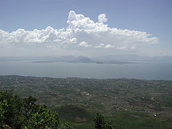
Homa Bay, fotografiert vom Mount Homa aus, 2007
Basisdaten
Einwohner
- Bevölkerungsdichte
32.174 Einw. [1]
163 Einw./km²
Fläche 197 km²
Höhe 1.330 m
Koordinaten 0° 31′ S, 34° 27′ O-0.5166666666666734.451330Koordinaten: 0° 31′ S, 34° 27′ O
Homa Bay (Kenia)
Homa Bay
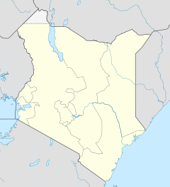
Homa Bay
Politik
Provinz Nyanza
Distrikt Homa Bay
Homepage von Homa Bay

Homa Bay ist eine Stadt mit etwa 33.000 Einwohnern[2] in der Provinz Nyanza in Kenia. Homa Bay ist die Hauptstadt des gleichnamigen Distrikts.

30 Kilometer von Homa Bay entfernt befindet sich der Eingang zum Ruma-Nationalpark.

Inhaltsverzeichnis

Klima

Das Klima in Homa Bay ist eher trocken, unterbrochen von zwei Regenzeiten pro Jahr. Zwischen März und Mai fällt langandauernder Regen, zwischen September und November gibt es immer wieder kürzere Niederschläge. Die durchschnittliche Niederschlagsmenge liegt dann bei etwa 1180 Millimeter. Die Durchschnittstemperatur in Homa Bay liegt zwischen 26 und 28 Grad Celsius.

Infrastruktur

Neben mehreren Primary Schools verfügt Homa Bay über zehn Secondary Schools und sechs Colleges. Neben dem staatlichen Krankenhaus gibt es eine von der römisch-katholischen Kirche geführte Klinik, ein von der anglikanischen Kirche geleitetes Gesundheitszentrum und sieben Privatkliniken.

Verkehr

Acht Kilometer südöstlich von Homa Bay befindet sich ein Behelfsflugplatz.

Einzelnachweise

  1. Kenyan Central Bureau of Statistics
  2. citypopulation.de

Wikimedia Foundation.

Игры ⚽ Поможем решить контрольную работу

Schlagen Sie auch in anderen Wörterbüchern nach:

  • Homa Bay — is a bay and town on the south shore of Winam Gulf of Lake Victoria, in western Kenya. It lies near Mount Homa (in the Luo language Got Uma or God Marahuma [ famous mountain ] ) and Ruma National Park, the latter noted for Jackson s hartebeests… …   Wikipedia

  • Homa Bay — Administration Pays  Kenya …   Wikipédia en Français

  • Homa Bay — Original name in latin Homa Bay Name in other language Homa, Homa Bay State code KE Continent/City Africa/Nairobi longitude 0.52731 latitude 34.45714 altitude 1165 Population 40319 Date 2013 06 27 …   Cities with a population over 1000 database

  • Homa Bay — Admin ASC 1 Code Orig. name Homa Bay Country and Admin Code KE.17 KE …   World countries Adminstrative division ASC I-II

  • Homa Bay District — Basisdaten Einwohner  Bevölkerungsdichte 288.540 Einw. 249 Einw./km² Fläche 1160 km² Koordinaten …   Deutsch Wikipedia

  • Homa Bay District — is an administrative district in the Nyanza Province of Kenya. Its capital town is Homa Bay. The district has a population of 288,540 (1999 census) and an area of 1,160 km² [http://www.statoids.com/yke.html] . The district has two constituencies …   Wikipedia

  • Homa Bay (comté du Kenya) — 0° 31′ 44″ S 34° 27′ 22″ E / 0.528889, 34.456111 …   Wikipédia en Français

  • Homa Bay (district du Kenya) — 0° 31′ 44″ S 34° 27′ 22″ E / 0.528889, 34.456111 …   Wikipédia en Français

  • Roman Catholic Diocese of Homa Bay — Infobox Diocese| jurisdiction=Diocese name=Homa Bay latin= Dioecesis Homa Bayensis country= Kenya metropolitan=Kisumu rite=Latin Rite cathedral = cocathedral = area= 7778 population= 1,970,000 population as of= catholics= 368,136 catholics… …   Wikipedia

  • Bistum Homa Bay — Basisdaten Staat Kenia Metropolitanbistum Erzbistum Kisumu …   Deutsch Wikipedia

Share the article and excerpts

Direct link
Do a right-click on the link above
and select “Copy Link”