- Cedar County (Nebraska)
-
Verwaltung US-Bundesstaat: Nebraska Verwaltungssitz: Hartington Adresse des
Verwaltungssitzes:County Courthouse
101 Broadway
P.O. Box 47
Hartington, NE 68739-0047Gründung: 1855 Gebildet aus: Dixon und Pierce County Vorwahl: 001 402 Demographie Einwohner: 8852 (2010) Bevölkerungsdichte: 4,6 Einwohner/km² Geographie Fläche gesamt: 1.932 km² Wasserfläche: 14 km² Karte 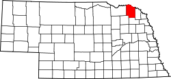
Website: www.co.cedar.ne.us Das Cedar County[2] ist ein County im US-amerikanischen Bundesstaat Nebraska. Bei der Volkszählung im Jahr 2010 hatte das County 8852 Einwohner und eine Bevölkerungsdichte von 4,6 Einwohnern pro Quadratkilometer. Der Verwaltungssitz (County Seat) ist Hartington, das nach dem englischen Lord Hartington benannt wurde.
Inhaltsverzeichnis
Geografie
Das County liegt im äußersten Nordosten von Nebraska an der Grenze zu South Dakota und hat eine Fläche von 1.932 Quadratkilometern, wovon 14 Quadratkilometer Wasserfläche sind. Es grenzt an folgende Countys:
Yankton County
(South Dakota)Clay County
(South Dakota)Knox County 
Dixon County Pierce County Wayne County Geschichte
Das Cedar County wurde 1855 auf einem Teil des Dixon und des Pierce County gebildet. Benannt wurde es nach den hier reichlich wachsenden Nadelbäumen, die zu einer der in Nordamerika als cedar („Zeder“) bezeichneten Arten gehörten.
Demografische Daten
Historische Einwohnerzahlen Census Einwohner ± in % 1860 246 — 1870 1032 300 % 1880 2899 200 % 1890 7028 100 % 1900 12.467 80 % 1910 15.191 20 % 1920 16.225 7 % 1930 16.427 1 % 1940 15.126 -8 % 1950 13.843 -8 % 1960 13.368 -3 % 1970 12.192 -9 % 1980 11.375 -7 % 1990 10.131 -10 % 2000 9615 -5 % 2010 8852 -8 % Vor 1900[3] 1900–1990[4] 2000[5] 2010[6]  Alterspyramide des Cedar County
Nach der Volkszählung im Jahr 2000 lebten im Cedar County 9.615 Menschen in 3.623 Haushalten und 2.565 Familien. Die Bevölkerungsdichte betrug 5 Einwohner pro Quadratkilometer. Ethnisch betrachtet setzte sich die Bevölkerung zusammen aus 99,07 Prozent Weißen, 0,10 Prozent Afroamerikanern, 0,20 Prozent amerikanischen Ureinwohnern, 0,04 Prozent Asiaten, 0,01 Prozent Bewohnern aus dem pazifischen Inselraum und 0,18 Prozent aus anderen ethnischen Gruppen; 0,40 Prozent stammten von zwei oder mehr Ethnien ab. 0,43 Prozent der Bevölkerung waren spanischer oder lateinamerikanischer Abstammung, die verschiedenen der genannten Gruppen angehörten.
Von den 3.623 Haushalten hatten 34,8 Prozent Kinder und Jugendliche unter 18 Jahre, die bei ihnen lebten. 63,6 Prozent waren verheiratete, zusammenlebende Paare, 4,3 Prozent waren allein erziehende Mütter, 29,2 Prozent waren keine Familien, 27,0 Prozent waren Singlehaushalte und in 15,7 Prozent lebten Menschen im Alter von 65 Jahren oder darüber. Die Durchschnittshaushaltsgröße lag bei 2,60 und die durchschnittliche Familiengröße bei 3,20 Personen.
Auf das gesamte County bezogen setzte sich die Bevölkerung zusammen aus 29,4 Prozent Einwohnern unter 18 Jahren, 6,0 Prozent zwischen 18 und 24 Jahren, 24,2 Prozent zwischen 25 und 44 Jahren, 20,3 Prozent zwischen 45 und 64 Jahren und 20,0 Prozent waren 65 Jahre alt oder darüber. Das Durchschnittsalter betrug 39 Jahre. Auf 100 weibliche kamen statistisch 100,1 männliche Personen. Auf 100 Frauen im Alter von 18 Jahren oder darüber kamen statistisch 97,1 Männer.
Das jährliche Durchschnittseinkommen eines Haushalts betrug 33.435 USD, das Durchschnittseinkommen der Familien betrug 39.422 USD. Männer hatten ein Durchschnittseinkommen von 26.707 USD, Frauen 18.370 USD. Das Pro - Kopf - Einkommen betrug 15.514 USD. 6,3 Prozent der Familien und 9,1 Prozent der Bevölkerung lebten unterhalb der Armutsgrenze. Davon waren 10,7 Prozent Kinder oder Jugendliche unter 18 Jahre und 9,7 Prozent waren Menschen über 65 Jahre.[7]
Städte und Gemeinden
- Hartington
- Laurel
- Randolph
- Belden
- Coleridge
- Fordyce
- Magnet
- Obert
- St. Helena
- Wynot
- Bow Valley
- St. James
- South Yankton
Einzelnachweise
- ↑ Auszug aus dem National Register of Historic Places. Abgerufen am 13. März 2011
- ↑ GNIS-ID: 835835. Abgerufen am 22. Februar 2011 (englisch).
- ↑ U.S. Census Bureau _ Census of Population and Housing Abgerufen am 17. Februar 2011
- ↑ Auszug aus Census.gov Abgerufen am 17. Februar 2011
- ↑ Auszug aus factfinder.census.gov Abgerufen am 18. Februar 2011
- ↑ United States Census 2010 Abgerufen am 21. August 2011
- ↑ Cedar County, Nebraska Datenblatt mit den Ergebnissen der Volkszählung im Jahre 2000 bei factfinder.census.gov
Weblinks
-
 Commons: Cedar County, Nebraska – Sammlung von Bildern, Videos und Audiodateien
 - Offizielle Webseite
- U.S. Census Buero, State & County QuickFacts - Cedar County
- Yahoo Bildersuche - Cedar County
- www.city-data.com - Cedar County

Liste der Countys in Nebraska
Adams | Antelope | Arthur | Banner | Blaine | Boone | Box Butte | Boyd | Brown | Buffalo | Burt | Butler | Cass | Cedar | Chase | Cherry | Cheyenne | Clay | Colfax | Cuming | Custer | Dakota | Dawes | Dawson | Deuel | Dixon | Dodge | Douglas | Dundy | Fillmore | Franklin | Frontier | Furnas | Gage | Garden | Garfield | Gosper | Grant | Greeley | Hall | Hamilton | Harlan | Hayes | Hitchcock | Holt | Hooker | Howard | Jefferson | Johnson | Kearney | Keith | Keya Paha | Kimball | Knox | Lancaster | Lincoln | Logan | Loup | Madison | McPherson | Merrick | Morrill | Nance | Nemaha | Nuckolls | Otoe | Pawnee | Perkins | Phelps | Pierce | Platte | Polk | Red Willow | Richardson | Rock | Saline | Sarpy | Saunders | Scotts Bluff | Seward | Sheridan | Sherman | Sioux | Stanton | Thayer | Thomas | Thurston | Valley | Washington | Wayne | Webster | Wheeler | York
Wikimedia Foundation.
Schlagen Sie auch in anderen Wörterbüchern nach:
Cedar County, Nebraska — Infobox U.S. County county = Cedar County state = Nebraska founded = 1855 seat wl = Hartington | largest city wl = Hartington area total sq mi =746 area land sq mi =740 area water sq mi =6 area percentage = 0.75% census yr = 2000 pop = 9615… … Wikipedia
National Register of Historic Places listings in Cedar County, Nebraska — Location of Cedar County in Nebraska This is a list of the National Register of Historic Places listings in Cedar County, Nebraska. It is intended to be a complete list of the properties and districts on the National Register of Historic Places… … Wikipedia
Cedar County — is the name of three currently existing counties in the United States, as well as one proposed and one abolished one:* Cedar County, Iowa * Cedar County, Missouri * Cedar County, Nebraska * Cedar County, Utah, abolished in 1862. * Cedar County,… … Wikipedia
Cedar Township, Nebraska — may refer to the following places:*Cedar Township, Antelope County, Nebraska *Cedar Township, Buffalo County, Nebraska *Cedar Township, Nance County, Nebraska … Wikipedia
Cedar County — Es gibt in den Vereinigten Staaten drei Countys mit dem Namen Cedar County: Cedar County (Iowa) Cedar County (Missouri) Cedar County (Nebraska) Diese Seite ist eine Begriffsklärung … Deutsch Wikipedia
Cedar Rapids, Nebraska — Infobox Settlement official name = Cedar Rapids, Nebraska settlement type = Village nickname = motto = imagesize = image caption = image imagesize = image caption = image mapsize = 250px map caption = Location of Cedar Rapids, Nebraska mapsize1 … Wikipedia
Cedar Bluffs, Nebraska — Infobox Settlement official name = Cedar Bluffs, Nebraska settlement type = Village nickname = motto = imagesize = image caption = image imagesize = image caption = image mapsize = 250px map caption = Location of Cedar Bluffs, Nebraska mapsize1 … Wikipedia
Cedar Creek, Nebraska — Infobox Settlement official name = Cedar Creek, Nebraska settlement type = Village nickname = motto = imagesize = image caption = image imagesize = image caption = image mapsize = 250px map caption = Location of Cedar Creek, Nebraska mapsize1 =… … Wikipedia
Cedar County Courthouse — ist die Bezeichnung mehrerer Courthouses in den Vereinigten Staaten: Cedar County Courthouse (Iowa) Cedar County Courthouse (Missouri) Cedar County Courthouse (Nebraska), NRHP Nr. 89002214 Diese Seite ist eine Begriffsklärung … Deutsch Wikipedia
Dixon County, Nebraska — Dixon County courthouse in Ponca … Wikipedia
Cedar County (Nebraska)


18+
© Academic, 2000-2024
- Kontaktieren Sie uns: Unterstützung, Werbung
Wörterbücher Export, schritte mit PHP, Joomla, Drupal, WordPress, MODx.