- Mount Balbi
-
Mount Balbi 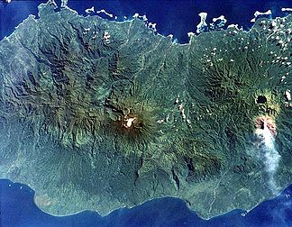
Der Vulkan Balbi im Zentrum des Bildes (Bild: NASA)
Höhe 2.715 m Lage Bougainville, Papua Neuguinea Geographische Lage 5° 55′ 0″ S, 154° 59′ 0″ O-5.9166666666667154.983333333332715Koordinaten: 5° 55′ 0″ S, 154° 59′ 0″ O 

Typ Schichtvulkan Letzte Eruption unbekannt Besonderheiten Höchster Berg der Insel Bougainville Der Schichtvulkan Balbi bildet mit 2715 Metern Höhe den höchsten Punkt der Insel Bougainville. Nördlich des Gipfels gibt es eine Kette von fünf Kratern, wobei einer einen See enthält. Im Krater B an der Westflanke des Balbi lässt sich Fumarolentätigkeit beobachten. Der Vulkan ist in historischer Zeit nicht ausgebrochen, es liegen nur unsichere Aufzeichnungen über eine mögliche Eruption um das Jahr 1825 (± 25 Jahre) vor.
Weblinks
- Mount Balbi im Global Volcanism Program der Smithsonian Institution (englisch)
Kategorien:- Zweitausender
- Schichtvulkan
- Bougainville
- Berg in Papua-Neuguinea
- Berg in Australien und Ozeanien


Wikimedia Foundation.