Rukkirahu

Rukkirahu

Vorlage:Infobox Insel/Wartung/Fläche fehltVorlage:Infobox Insel/Wartung/Höhe fehlt

Rukkirahu
Blick von Norden auf Rukkirahu mit seinem Richtfeuer
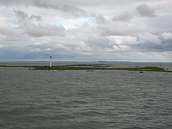
Gewässer Väinameri (Ostsee)
Geographische Lage 58° 54′ 14″ N, 23° 21′ 5″ O58.90388888888923.351388888889Koordinaten: 58° 54′ 14″ N, 23° 21′ 5″ O
Rukkirahu (Estland)
Rukkirahu
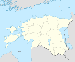
Einwohner (unbewohnt)

Rukkirahu (deutsch Rukki) ist eine unbewohnte westestnische Ostsee-Insel im Väinameri.

Sie liegt westlich des Festlandsdorfs Rohuküla mit seinem bekannten Hafen. Die Insel gehört verwaltungsmäßig zur Gemeinde Ridala im Kreis Lääne.

Auf der Insel befindet sich seit 1860 ein Richtfeuer, das besonders für die Schiffsverbindung zwischen Heltermaa auf der Insel Hiiumaa und Rohuküla von Bedeutung ist. Auf dem heutigen weißen Betonturm befindet sich ein Laternenraum mit umgehendem Balkon. Der Lichtstrahl ist 5 bis 6 Seemeilen weit zu sehen.

Weblinks


Wikimedia Foundation.

Игры ⚽ Нужно сделать НИР?

Schlagen Sie auch in anderen Wörterbüchern nach:

  • Saaremaa — This article is about the island. For the village in Võru County, see Saaremaa, Võru County. Saaremaa …   Wikipedia

  • Hiiumaa — Tahkuna peninsula is the most northern part of Hiiumaa Geography …   Wikipedia

  • List of islands of Estonia — This is a list of islands of Estonia. There are 1521 islands. This is not a complete list. CompactTOC10|sections= A B C D E F G H I J K L M N O P Q R S Š Z Ž T U V W Õ Ä Ö Ü X YAAbruka Adralaid Aegna (Wulf) Ahelaid Aherahu (Atla) Aherahu Ahessäär …   Wikipedia

  • Vormsi — Estonia s fourth largest island, Vormsi (German: Worms, Swedish: Ormsö), is located between Hiiumaa and the mainland with a total area of 93 square kilometers. It is part of a rural municipality Vormsi Parish. From mainland, Vormsi is separated… …   Wikipedia

  • Muhu — (German: Mohn/Moon; in Estonian also called Muhumaa), is an island in the Baltic Sea. With an area of 198 km² it is the third largest island belonging to Estonia, after Saaremaa and Hiiumaa. Together with neighbouring smaller islands of… …   Wikipedia

  • Naissaar — from the air Viimsi parish Naissaar …   Wikipedia

  • Osmussaar — Limestone cliff on the east coast of Osmussaar Geography Location …   Wikipedia

  • Manilaid — Manija   village   Manilaid in the Gulf of Riga. Coord …   Wikipedia

  • Noogimaa — is a small, uninhabited Estonian island in the Baltic Sea. Its coordinates are: 58°22′09″N 21°54′45″E / 58.36917°N 21.9125°E / 58.36917; 21.9125. Noogimaa lies just south of the is …   Wikipedia

  • Ninalaid — is a small Baltic Sea island belonging to the country of Estonia. Its coordinates are 58°59′52″N 22°26′31″E / 58.99778°N 22.44194°E / 58.99778; 22.44194. Ninalaid lies just off the …   Wikipedia

Share the article and excerpts

Direct link
Do a right-click on the link above
and select “Copy Link”