Venice (Louisiana)

Venice (Louisiana)
Venice
Spitzname: "The end of the world"
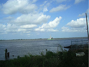
Der Mississippi in Venice wenige Kilometer vor dessen Mündung
Lage in Louisiana
Venice (Louisiana)
Venice
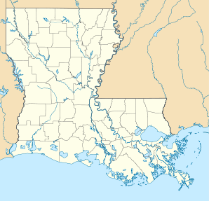
Venice
Basisdaten
Staat: Vereinigte Staaten
Bundesstaat: Louisiana
Parish:

Plaquemines Parish

Koordinaten: 29° 17′ N, 89° 21′ W29.276944444444-89.3547222222220Koordinaten: 29° 17′ N, 89° 21′ W
Zeitzone: Central Standard Time (UTC−6)
Einwohner: 460 (Stand: 2000)
Bevölkerungsdichte: 68,7 Einwohner je km²
Fläche: 6,7 km² (ca. 3 mi²)
Höhe: 0 m
Postleitzahl: 70091
Vorwahl: +1 504
FIPS: 22-78015
GNIS-ID: 558337

Venice ist eine Siedlung, die keiner Gemeinde angehört, im Plaquemines Parish[1] im Südosten des US-amerikanischen Bundesstaates Louisiana mit 460 Einwohnern.

Inhaltsverzeichnis

Geschichte

Durch den Hurrikan Katrina im Jahre 2005 ist Venice fast vollständig zerstört worden. Seitdem sind zahlreiche Gebäude erneut aufgebaut worden, die Auswirkungen sind aber noch erkennbar. Die Brücke, die nach Venice führt, wurde nicht zerstört.

Geografie

Venice, der Endpunkt der Great River Road, liegt 121 Kilometer südöstlich von New Orleans und ist der letzte über Straßen erreichbare Ort am Mississippi wenige Kilometer vor dessen Mündung in den Golf von Mexiko. Venice liegt am westlichen Ufer des Mississippi auf 29° 16′ 37″ nördlicher Breite und 89° 21′ 17″ westlicher Länge. [2]

Wirtschaft

Im Ort spielt sowohl der kommerzielle Fischfang als auch das Sportangeln eine große Rolle. Es gibt eine Marina und zahlreiche Veranstalter für Angeltouren.

Ölteppich vor dem Mississippi-Delta, Aufnahme vom 30. April 2010

Ein weiterer Wirtschaftszweig ist die Versorgung der zahlreichen Bohrplattformen vor der Küste. Eine dieser Anlagen zur Ölförderung, die Plattform Deepwater Horizon, etwa 84 km südöstlich von Venice im Golf von Mexiko gelegen, sank am 22. April 2010 nach einer Explosion. Als Folge dieses Unfalls lief Rohöl aus dem Leck in 1500 m Seetiefe und verursachte eine Ölpest von bis dahin nicht vorgekommenen Ausmaßen. Das bedeutet eine Umweltkatastrophe für die sensible Tier- und Pflanzenwelt im Flussdelta des Mississippi und in weiteren Küstenbereichen des Golfs, aber auch eine Bedrohung der Lebensgrundlage der Einwohner von Venice und anderer Küstenorte.

Einzelnachweise

  1. Find a County
  2. Koordinaten von Venice

Weblinks

 Commons: Venice, Louisiana – Sammlung von Bildern, Videos und Audiodateien

Wikimedia Foundation.

Игры ⚽ Поможем написать реферат

Schlagen Sie auch in anderen Wörterbüchern nach:

  • Venice, Louisiana — Geobox Town name = Venice native name = other name = other name1 = category = Unincorporated community image size = image caption = flag size = symbol = symbol size = symbol type = nickname = motto = country = United States state = Louisiana… …   Wikipedia

  • Boothville-Venice, Louisiana — Coordinates: 29°19′04″N 89°23′25″W / 29.31778°N 89.39028°W / 29.31778; 89.39028 …   Wikipedia

  • Venice — bezeichnet: Venice (Band), US amerikanische Band Venice (Florida), Stadt in Florida Venice (Los Angeles), Stadtteil in Kalifornien Venice (Louisiana), Ortschaft in Louisiana Venice (Album), Album des Musikers Fennesz Venice (Illinois), Stadt in… …   Deutsch Wikipedia

  • Louisiana locations by per capita income — Louisiana has the forty seventh highest per capita income in the United States of America, at $16,912 (2000). Its personal per capita income is $26,100 (2003). Louisiana parishes ranked by per capita income There are sixty four parishes located… …   Wikipedia

  • Venice (disambiguation) — The name Venice may refer to:*Venice, Italy *Republic of VenicePlaces in the United States*Venice, Los Angeles, California *Venice, Florida *Venice, Illinois *Venice, Louisiana *Venice, New YorkOther uses*Venice (band), a band from Venice,… …   Wikipedia

  • Louisiana Highway 23 — Infobox LA Highway type=State route=23 length mi=74.02 length ref= [http://southeastroads.com/la state highways.html Louisiana State Highway Log] ] length round=2 formed=1955 renumbering dir1=South dir2=North from=Begin State Maintenance in… …   Wikipedia

  • Plaquemines Parish, Louisiana — Infobox U.S. County county = Plaquemines Parish state = Louisiana founded year = 1807 founded date = seat wl = Pointe à la Hache largest city wl = Belle Chasse area total sq mi = 2429 area total km2 = 6290 area land sq mi = 845 area land km2 =… …   Wikipedia

  • Pilottown, Louisiana — Geobox Settlement name = Pilottown native name = other name = other name1 = category = Census designated place image size = 200px image caption = Pilot Town in the 1880s flag size = symbol = symbol size = symbol type = nickname = motto = country …   Wikipedia

  • Port Eads, Louisiana — Geobox Settlement name = Port Eads native name = other name = other name1 = category = Census designated place image size = image caption = flag size = symbol = symbol size = symbol type = nickname = motto = country = United States state =… …   Wikipedia

  • List of census-designated places in Louisiana — This page lists census designated places (CDPs) in the U.S. state of Louisiana. As of the 2000 census, there were a total of 96 census designated places in Louisiana.By Name (Alphabetically)By ParishTwenty three of Louisiana s sixty four parishes …   Wikipedia

Share the article and excerpts

Direct link
Do a right-click on the link above
and select “Copy Link”