Lukeville — Localización de Lukeville en el Condado de Pima. Lukeville es una pequeña población fronteriza ubicada en el estado de Arizona, Estados Unidos, ubicada en la Frontera entre Estados Unidos y México, frente a la población mexicana … Wikipedia Español
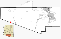
Lukeville, Arizona — Lukeville is a small unincorporated border town in southern Pima County, Arizona, United States.The city consists of the international border crossing into Sonoyta, Sonora, Mexico, together with a gas station, a duty free shop, a few outlets that … Wikipedia
85341 — Lukeville, Az (Miscellaneous » ZIP Codes) … Abbreviations dictionary
National Register of Historic Places listings in Pima County, Arizona — Location of Pima County in Arizona This is a list of the National Register of Historic Places listings in Pima County, Arizona. This is intended to be a complete list of the properties and districts on the National Register of Historic Places in… … Wikipedia
National Register of Historic Places listings in Organ Pipe Cactus National Monument — This is a list of the National Register of Historic Places listings in Organ Pipe Cactus National Monument. This is intended to be a complete list of the properties and districts on the National Register of Historic Places in Organ Pipe Cactus… … Wikipedia
Sonoyta — Infobox Settlement official name = Sonoyta other name = native name = nickname = settlement type = Town motto = imagesize = image caption = flag size = image seal size = image shield = shield size = city logo = citylogo size = mapsize = map… … Wikipedia
Arizona State Route 85 — Infobox road marker state=AZ highway name= name notes= type=state route=85 alternate name= maint=ADOT length mi=128.86 length round=2 length ref=cite web |url=http://tpd.az.gov/data/reports/2006SHSLog.pdf |title=2006 ADOT Highway Log… … Wikipedia
Arizona State Highway 85 — Karte … Deutsch Wikipedia
Arizona State Route 85 — Longueur 207,38 km (128,86 mi) … Wikipédia en Français
Mexican Federal Highway 8 — Federal Highway 8 Carretera Federal 8 Route information Maintained by Board of Highways of the State of Sonora … Wikipedia
 Lage im County und in Arizona