- Macauley Island
-
Macauley Island Macauley Island im Jahre 2003, von Nordost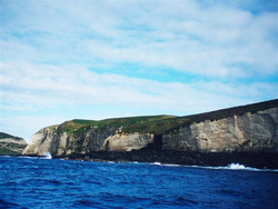
Gewässer Pazifischer Ozean Inselgruppe Kermadecinseln Geographische Lage 30° 13′ 57″ S, 178° 25′ 55″ W-30.2325-178.43194444444238Koordinaten: 30° 13′ 57″ S, 178° 25′ 55″ W 
Länge 2,1 km Breite 1,6 km Fläche 3,06 km² Höchste Erhebung Mount Haszard
238 mEinwohner (unbewohnt) Karte der Kermadecinseln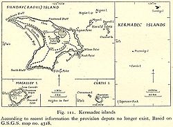
Macauley Island (früher Macaulay Island) ist die zweitgrößte Insel der neuseeländischen Kermadecinseln. Sie liegt im pazifischen Ozean, 110 km südsüdwestlich von Raoul Island.
Der Mount Haszard erreicht eine Höhe von 238 Metern, die Insel ist etwa 2 km lang und zusammen mit der 220 Meter östlich gelegenen Nebeninsel Haszard Island 3,06 km² groß (davon Haszard Island etwa fünf Hektar oder 0,05 km²).
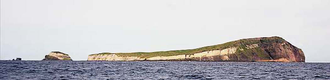 Macauley Island von Nordosten aus, mit vorgelagerter Haszard Island (links)
Die Insel hat einen vulkanischen Ursprung, der letzte Vulkanausbruch fand laut Radiokarbonmessung in der zweiten Hälfte des 5. Jahrtausends v. Chr. statt. In den Jahren 1825 und 1887 gab es Hinweise auf Eruptionen in der Nähe der Macauleyinsel.
Bis zum 19. Jahrhundert haben hier zeitweise Siedler gelebt, seitdem ist die Insel unbewohnt. Bei schlechtem Wetter ist die Anlandung von Booten unmöglich. Macauley Island ist ein Bestandteil des Kermadec Marine Reserve und darf daher nicht besiedelt und nur unter Auflagen betreten werden.
Weblinks
 Commons: Macauley Island – Sammlung von Bildern, Videos und Audiodateien
- Volcanic history of Macauley Island, Kermadec Ridge, New Zealand The Royal Society of New Zealand (englisch)
- Macauley Island im Global Volcanism Program der Smithsonian Institution (englisch)
- National Oceanic and Atmospheric Administration Map of Macauley and Giggenbach submarine volcanoes — Picture of island and article by Ian Wright, Ocean Geology, National Institute of Water and Atmospheric Research, Wellington, New Zealand (englisch)
Kategorien:- Unbewohnte Insel
- Kermadecinseln
- Insel (Neuseeland)
- Insel (Australien und Ozeanien)
- Insel (Pazifischer Ozean)
- Caldera


Wikimedia Foundation.