Machias Seal Island

Machias Seal Island

Vorlage:Infobox Insel/Wartung/Höhe fehlt

Machias Seal Island
Machias Seal Island
Machias Seal Island
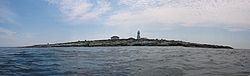
Gewässer Golf von Maine (Atlantischer Ozean)
Geographische Lage 44° 30′ 10″ N, 67° 6′ 10″ W44.502777777778-67.102777777778Koordinaten: 44° 30′ 10″ N, 67° 6′ 10″ W
Machias Seal Island (Maine)
Machias Seal Island
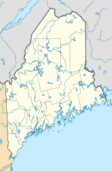
Fläche 8 ha
Einwohner (unbewohnt)

Machias Seal Island ist eine unbewohnte Atlantik-Insel vor Maine, USA, mit einer Fläche von ca. 80.000 m².

Seit 1832 besteht ein Gebietsdisput mit Kanada im Rahmen der Gebietsansprüche zwischen Kanada und den Vereinigten Staaten. Die Insel war in den 1970er und 1980er Jahren von den Familien der Leuchtfeuerwärter der Canadian Coast Guard bewohnt.

Die Insel befindet sich im Golf von Maine, etwa 16 km südöstlich von Cutler (Maine) und ca. 19 km südwestlich von Southwest Head (New Brunswick; nahe Grand Manan Island).


Wikimedia Foundation.

Игры ⚽ Поможем написать курсовую

Schlagen Sie auch in anderen Wörterbüchern nach:

  • Machias Seal Island — Infobox Islands name = Machias Seal Island image caption = Machias Seal Island image size = 250px locator native name = native name link = nickname = location = Gulf of Maine coordinates = coord|44|30|10|N|67|06|10|W|type:isle archipelago = Grand …   Wikipedia

  • Seal Island — can refer to:*Machias Seal Island located in the Gulf of Maine *Seal Island, South Africa located just off the coast of South Africa and known primarily for attacks by Great White Sharks on the Cape Fur Seal *Seal Island, Nova Scotia located just …   Wikipedia

  • Refuge d'oiseaux de l'île Machias Seal — Machias Seal Island Bird Sanctuary Catégorie IV de la CMAP (Aire de gestion des habitats/espèces) [1] Emplacement   …   Wikipédia en Français

  • Île Machias Seal — Machias Seal Island (en) Géographie Pays …   Wikipédia en Français

  • Machias — may refer to:* Machias, New York * Machias, Maine * Machias (CDP), Maine * Machias, Washington * Machias Seal Island …   Wikipedia

  • Grand Manan Island — Strand bei North Head Gewässer Bay of Fundy I …   Deutsch Wikipedia

  • Grand Manan Island (New Brunswick) — Grand Manan Island (also simply Grand Manan) is a Canadian island, and the largest in the Bay of Fundy. It is also the primary island in the Grand Manan Archipelago, sitting at the boundary between the Bay of Fundy and the Gulf of Maine on the… …   Wikipedia

  • Campobello Island — is a Canadian island located at the entrance to Passamaquoddy Bay, adjacent to the entrance to Cobscook Bay, and within the Bay of Fundy. The island is part of Charlotte County, New Brunswick but is actually physically connected by the Franklin… …   Wikipedia

  • Parc national d'Elk Island — Parc national Elk Island Parc national Elk Island Catégorie II de la CMAP (Parc national) Pays  Canada Province …   Wikipédia en Français

  • Parc national elk island — Catégorie II de la CMAP (Parc national) Pays  Canada Province …   Wikipédia en Français

Share the article and excerpts

Direct link
Do a right-click on the link above
and select “Copy Link”