- Marantao
-
Municipality of Marantao Lage von Marantao in der Provinz Lanao del Sur 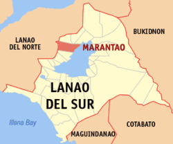
Basisdaten Bezirk: Autonomous Region in Muslim Mindanao Provinz: Lanao del Sur Barangays: 34 Distrikt: 1. Distrikt von Lanao del Sur PSGC: 153616000 Einkommensklasse: 3. Einkommensklasse Haushalte: 3598 Zensus 1. Mai 2000Einwohnerzahl: 32.075 Zensus 1. August 2007Koordinaten: 7° 57′ N, 124° 14′ O7.95124.233Koordinaten: 7° 57′ N, 124° 14′ O Postleitzahl: 9711 Bürgermeister: Mohammadali A. Abinal Offizielle Webpräsenz: Marantao Geographische Lage auf den Philippinen 

Marantao Marantao ist eine philippinische Stadtgemeinde in der Provinz Lanao del Sur. Nach dem Zensus vom 1. Mai 2000 hat sie 24.647 Einwohner in 3598 Haushalten.
Baranggays
Marantao ist politisch in 34 Baranggays unterteilt.
- Bacayawan
- Cawayan Bacolod
- Bacong
- Camalig Bandara Ingud
- Camalig Bubong
- Camalig (Pob.)
- Inudaran Campong
- Cawayan
- Daanaingud
- Cawayan Kalaw
- Kialdan
- Lumbac Kialdan
- Cawayan Linuk
- Lubo
- Inudaran Lumbac
- Mantapoli
- Matampay
- Maul
- Nataron
- Pagalongan Bacayawan
- Pataimas
- Poona Marantao
- Punud Proper
- Tacub
- Maul Ilian
- Palao
- Banga-Pantar
- Batal-Punud
- Bubong Madanding (Bubong)
- Ilian
- Inudaran Loway
- Maul Lumbaca Ingud
- Poblacion
- Tuca Kialdan
Städte und Stadtgemeinden in der Provinz Lanao del SurStädte: Marawi City
Stadtgemeinden: Bacolod-Kalawi | Balabagan | Balindong | Bayang | Binidayan | Buadiposo-Buntong | Bubong | Bumbaran | Butig | Calanogas | Ditsaan-Ramain | Ganassi | Kapai | Kapatagan | Lumba-Bayabao | Lumbaca-Unayan | Lumbatan | Lumbayanague | Madalum | Madamba | Maguing | Malabang | Marantao | Marogong | Masiu | Mulondo | Pagayawan | Piagapo | Picong | Poona Bayabao | Pualas | Saguiaran | Sultan Dumalondong | Tagoloan II | Tamparan | Taraka | Tubaran | Tugaya | Wao
Wikimedia Foundation.
Schlagen Sie auch in anderen Wörterbüchern nach:
Marantao — Original name in latin Marantao Name in other language Marantao State code PH Continent/City Asia/Manila longitude 7.95 latitude 124.23333 altitude 716 Population 3572 Date 2011 07 31 … Cities with a population over 1000 database
Marantao, Lanao del Sur — Marantao is a 3rd class municipality in the province of Lanao del Sur, Philippines. According to the 2000 census, it has a population of 24,647 people in 3,598 households. Barangays Marantao is politically subdivided into 34 barangays. Bacayawan… … Wikipedia
Marawi City — Lage von Marawi City in der Provinz Lanao del Sur Basisdaten Bezirk … Deutsch Wikipedia
Marawi — For other uses, see Merowe. Islamic City of Marawi Lungsod Islamiko ng Marawwi Marawi City City … Wikipedia
Marawi — Dakbayang Islamiko sa Marawi Ciudad Islámica de Marawi Marawi con una vista del Lanao Apodo(s): La Cabecera de Verano del Sur … Wikipedia Español
Marawi City — Infobox Settlement official name = Islamic City of Marawi other name = native name = nickname = The Summer Capital of the South settlement type = motto = imagesize = image caption = Islamic Center of Marawi City flag size = image seal size =… … Wikipedia
Malabang, Lanao del Sur — Malabang is a 4th class municipality in the province of Lanao del Sur, Philippines. According to the 2000 census, it has a population of 33,177 people in 4,883 households. Contents 1 Municipality Mayor Anwar Balindong 2 History … Wikipedia
Farouk Sharif — His Royal Highness Sultan FAROUK RAWA GANDAROSA SHARIF is the crowned Sultan of Taporog, Poona Bayabao, Lanao del Sur, PhilippinesReign: July 1998 presentBorn:Royal House: House of SharifFather: Late Abdullah SharifMother: Late Hadji Aminah Rawa… … Wikipedia
PH-LAS — Lage von Lanao del Sur Lanao del Sur ist eine Provinz im Zentralteil der Insel Mindanao auf den Philippinen. Lanao del Sur gehört zum Bezirk ARMM, der Autonomous Region in Muslim Mindanao. Die Hauptstadt der Provinz liegt am Lake Lanao und heißt… … Deutsch Wikipedia
Confederation of sultanates in Lanao — The Sultanates of Lanao in Mindanao, Philippines were founded in the 16th century through the influence of Shariff Kabungsuan, who was enthroned as first Sultan of Maguindanao in 1520. The Maranaos of Lanao were acquainted with the sultanate… … Wikipedia
Marantao


18+
© Academic, 2000-2024
- Kontaktieren Sie uns: Unterstützung, Werbung
Wörterbücher Export, schritte mit PHP, Joomla, Drupal, WordPress, MODx.