Mount Pirongia

Mount Pirongia
Mount Pirongia
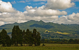
Mount Pirongia, 4. April 2008

Mount Pirongia, 4. April 2008

Höhe 959 m
Lage Nordinsel, Neuseeland
Gebirge Hakarimata Range
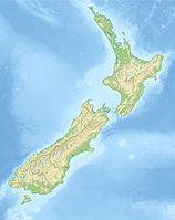
Geographische Lage 37° 59′ 28″ S, 175° 5′ 21″ O-37.991077175.089243959Koordinaten: 37° 59′ 28″ S, 175° 5′ 21″ O
Mount Pirongia (Neuseeland)
Mount Pirongia
Typ erloschener Vulkan
Alter des Gesteins Pliozän

Mount Pirongia ist ein erloschener Vulkan in der Region Waikato auf der Nordinsel Neuseelands. Er erreicht eine Höhe von 959 Metern und ist damit der höchste Berg der Region. Der Vulkan war im späten Pliozän und frühen Pleistozän aktiv.

Er befindet sich 22 km westlich von Te Awamutu und acht Kilometer von der kleinen Siedlung Pirongia entfernt in einem Waldschutzgebiet. Er ist bereits von der Tasmansee aus sichtbar, da er nur 25 km von der Küste bei Aotea Harbour entfernt liegt.

Der Mount Pirongia Forest Park ist bei Jägern aus Hamilton für Tagesausflüge beliebt. Mehrere Herden wilder Ziegen leben auf seinen mit Buschwerk bewachsenen Hängen. Der Park wird von Büro Waikato des Department of Conservation in Hamilton verwaltet.

Weblinks


Wikimedia Foundation.

Игры ⚽ Нужно сделать НИР?

Schlagen Sie auch in anderen Wörterbüchern nach:

  • Mount Pirongia — Mt. Pirongia, 4 April 2008 Elevation 959 m (3,146 ft) …   Wikipedia

  • Pirongia — is a small town in the Waikato region of New Zealand s North Island.It is 12 kilometres to the west of Te Awamutu, on the banks of the Waipa River, close to the foot of the 962 metre Mount Pirongia, which lies in a forest park to the west of the… …   Wikipedia

  • Pirongia — Pironga …   Deutsch Wikipedia

  • Hamilton (Waikato) — Hamilton City Council Karte Basisdaten Region: Waikato …   Deutsch Wikipedia

  • List of mountains — Eight thousanders The 14 eight thousanders , 8,000 meters or higher above sea level, all in the Himalayas: *Everest (8,848 m), Nepal Tibet (China), Asia *K2 (8,611 m), Pakistan Xinjiang (China), Asia *Kangchenjunga (8,586 m), Nepal Sikkim (India) …   Wikipedia

  • Hamilton (Neuseeland) — Hamilton City Council Karte Basisdaten Region …   Deutsch Wikipedia

  • List of mountains of New Zealand by height — The following is a list of the highest mountains in New Zealand, and also of some other notable mountains and hills, ordered by height.The 30 highest mountainsThe 30 highest mountains [This list excludes mountains in the Ross Dependency, an area… …   Wikipedia

  • Te Awamutu — Infobox Settlement name =Te Awamutu official name = other name = native name = nickname = T.A. settlement type =Town total type =Region motto = imagesize = image caption = flag size = image seal size = image shield = shield size = image blank… …   Wikipedia

  • Gannet Island — ( Karewa in Māori) is a small island some 19 kilometres (12 miles) offshore from Kawhia on the west coast of New Zealand s North Island. Protected as a wildlife sanctuary, [ [http://interim.legislation.govt.nz/libraries/contents/om… …   Wikipedia

  • Gannet Island — Vorlage:Infobox Insel/Wartung/Fläche fehlt Gannet Island Gannet Island aus der Luft gesehen Gewässer …   Deutsch Wikipedia

Share the article and excerpts

Direct link
Do a right-click on the link above
and select “Copy Link”