- Ruamahanga River
-
Ruamahanga River 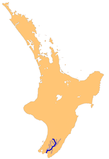
Lage des Ruamahanga River in Neuseeland
Daten Lage Region Wellington, Nordinsel (Neuseeland) Flusssystem Ruamahanga River Abfluss über Lake Ononoke → Palliser Bay → Cookstraße Mündung in den Lake Ononoke -41.371707175.140553Koordinaten: 41° 22′ 18″ S, 175° 8′ 26″ O
41° 22′ 18″ S, 175° 8′ 26″ O-41.371707175.140553Länge 130 km Rechte Nebenflüsse Waingawa River, Waiohine River Linke Nebenflüsse Tauweru River Durchflossene Seen Lake Wairarapa Der Ruamahanga River ist ein Fluss im Südosten der Nordinsel Neuseelands.
Der Fluss entspringt nordwestlich von Masterton in den Tararua Ranges. Von dort verläuft er mit einer Länge von 130 km zuerst nach Süden, dann nach Südwesten. Er hat mehrere Zuflüsse, unter ihnen der Tauweru River bei Gladstone.
Die Städte Masterton, Gladston, Ponatahi, Martinborough, Pahautea, Pukio und Tuhitatrata liegen nahe am Fluss.
In seinem Unterlauf mäandriert der Fluss in einer weiten Flutebene, insbesondere in dem Feuchtgebiet entlang der Ostküste des Lake Wairarapa, dessen Abfluss kurz vor der Flussmündung in den Ruamahanga River mündet. Einst durchfloss der Fluss den See, wurde aber später um ihn herumgeleitet.
Der Fluss mündet direkt an der Küste in den vom Meer getrennten Lake Ononoke, der bei Lake Ferry einen schmalen Auslass zur Palliser Bay an der Cookstraße hat.
Der Fluss ist zum Forellenangeln beliebt, im oberen Teil gibt es viele zum Baden geeignete Stellen.
Kategorien:- Fluss in Neuseeland
- Fluss in Australien und Ozeanien
- Wellington (Region)

Wikimedia Foundation.