- South Bedfordshire
-
South Bedfordshire District 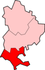
Lage in BedfordshireStatus District Region East of England Verw.grafschaft Bedfordshire Verwaltungssitz Dunstable Fläche 212,82 km² (182.) Einwohner 118.200 (172.) ONS-Code 09UE Website - Gründung 1974 Auflösung 2009 South Bedfordshire war ein District in der Grafschaft Bedfordshire in England. Verwaltungssitz war Dunstable; weitere bedeutende Orte waren Barton-le-Clay, Caddington, Eaton Bray, Houghton Regis, Linslade und Leighton Buzzard.
Der Bezirk wurde am 1. April 1974 gebildet und entstand aus der Fusion des Borough Dunstable, des Urban District Leighton-Linslade und des Rural District Luton. Am 1. April 2009 wurden der District mit dem benachbarten District Mid Bedfordshire zu einer neuen Unitary Authority Central Bedfordshire vereinigt.
Kategorien:- Ehemaliger District (East of England)
- Central Bedfordshire

Wikimedia Foundation.