- Balangkayan
-
Municipality of Balangkayan Lage von Balangkayan in der Provinz Eastern Samar 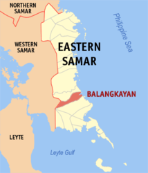
Basisdaten Bezirk: Eastern Visayas Provinz: Eastern Samar Barangays: 15 Distrikt: 1. Distrikt von Eastern Samar PSGC: 082603000 Einkommensklasse: 5. Einkommensklasse Haushalte: 1677 Zensus 1. Mai 2000Einwohnerzahl: 8.249 Zensus 1. August 2007Koordinaten: 11° 28′ N, 125° 31′ O11.466666666667125.51666666667Koordinaten: 11° 28′ N, 125° 31′ O Postleitzahl: 6801 Bürgermeister: Vegerano B. Gesite Offizielle Webpräsenz: www.balangkayan-esamar.gov.ph Geographische Lage auf den Philippinen 

Balangkayan Balangkayan ist eine philippinische Stadtgemeinde in der Provinz Eastern Samar. Nach dem Zensus vom 1. Mai 2000 hat sie 8134 Einwohner in 1677 Haushalten.
Baranggays
Balangkayan ist politisch in 15 Baranggays unterteilt.
- Balogo
- Bangon
- Cabay
- Caisawan
- Cantubi
- General Malvar
- Guinpoliran
- Julag
- Magsaysay
- Maramag
- Poblacion I
- Poblacion II
- Poblacion III
- Poblacion IV
- Poblacion V
Städte und Stadtgemeinden in der Provinz Eastern SamarStädte: Borongan City
Stadtgemeinden: Arteche | Balangiga | Balangkayan | Can-avid | Dolores | General MacArthur | Giporlos | Guiuan | Hernani | Jipapad | Lawaan | Llorente | Maslog | Maydolong | Mercedes | Oras | Quinapondan | Salcedo | San Julian | San Policarpo | Sulat | Taft
Wikimedia Foundation.
Schlagen Sie auch in anderen Wörterbüchern nach:
Balangkayan — Original name in latin Balangkayan Name in other language Balangkayan State code PH Continent/City Asia/Manila longitude 11.47139 latitude 125.51056 altitude 7 Population 3159 Date 2012 01 17 … Cities with a population over 1000 database
Balangkayan, Eastern Samar — Balangkayan is a 5th class municipality in the province of Eastern Samar, Philippines. According to the 2000 census, it has a population of 8,134 people in 1,677 households.BarangaysBalangkayan is politically subdivided into 15 barangays.* Balogo … Wikipedia
PH-EAS — Lage der Provinz Eastern Samar Die Provinz Eastern Samar liegt im Osten der Insel Samar auf den Philippinen und wird politisch dem Bezirk Eastern Visayas (Region VIII) zugeordnet. Der Hauptstadt der Provinzregierung, Borongan City, befindet sich… … Deutsch Wikipedia
Geography of the Philippines — Country geography name = the Philippines continent = Asia region = Southeast Asia coordinates = 13°00 N 122°00 E area ranking = 72nd km area = 300000 percent land = 99.38 km coastline = 36289 borders = None northernmost point = Y Ami island… … Wikipedia
Eastern Samar — Infobox Philippine province name = Eastern Samar sealfile = Ph seal eastern samar.png region = Eastern Visayas (Region VIII) capital = Borongan founded = June 19, 1965 pop2000 = 375,822 pop2000rank = 20th smallest popden2000 = 87 popden2000rank … Wikipedia
Dolores, Eastern Samar — Dolores is a 4th class municipality in the province of Eastern Samar, Philippines. According to the 2000 census, it has a population of 32,812 people in 6,313 households. In 1948, the barrios of Can avid, Carolina, Barok, Cansangaya, Mabuhay,… … Wikipedia
Maslog, Eastern Samar — Maslog is a 5th class municipality in the province of Eastern Samar, Philippines. According to the 2000 census, it has a population of 4,009 people in 723 households. Barangays Maslog is politically subdivided into 12 barangays. Bulawan Carayacay … Wikipedia
Maydolong, Eastern Samar — Municipality of Maydolong Municipality Map of Eastern Samar showing the location of Maydolong … Wikipedia
Mercedes, Eastern Samar — Map of Eastern Samar showing the location of Mercedes Mercedes is a 6th class municipality in the province of Eastern Samar, Philippines. According to the 2000 census, it has a population of 4,857 people in 945 households. Act No. 960 of the… … Wikipedia
Oras, Eastern Samar — Oras redirects here. For the Romanian town designation, see Oraş. Oras is a 4th class municipality in the province of Eastern Samar, Philippines. According to the 2000 census, it has a population of 31,315 people in 6,201 households. In 1948, San … Wikipedia
Balangkayan


18+
© Academic, 2000-2024
- Kontaktieren Sie uns: Unterstützung, Werbung
Wörterbücher Export, schritte mit PHP, Joomla, Drupal, WordPress, MODx.