- Narran River
-
Narran River 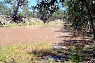
Narran River ca. 25 km nördlich des Narran Lake
Daten Lage Queensland / New South Wales (Australien) Flusssystem Murray River Verzweigung in der Flussaue Balonne River bei Dirranbandi
28° 36′ 29″ S, 148° 11′ 42″ O-28.608055555556148.195179Quellhöhe 179 m[1] Mündung Narran Lake -29.6010583147.4001614118Koordinaten: 29° 36′ 4″ S, 147° 24′ 1″ O
29° 36′ 4″ S, 147° 24′ 1″ O-29.6010583147.4001614118Mündungshöhe 118 m[1] Höhenunterschied 61 m Länge 299 km[1] Durchflossene Seen Narran Lake Kleinstädte Dirranbandi QLD, Redbank QLD, Angledool NSW, Bangate NSW, Boomali NSW, Narran Plains NSW Der Narran River ist ein Fluss im Osten Australiens an der Grenze zwischen den Bundesstaaten Queensland und New South Wales. Zusammen mit dem Culgoa River und dem Bokhara River ist der Narran River ein Arm des Balonne River – und zwar der östlichste dieser drei. Er fließt nach Süden auf den Barwon River, einen Quellfluss des Darling River, zu, erreicht in aber nicht, sondern endet im abflusslosen Narran Lake nördlich des Barwon River.
Im März 2010 flutete der Narran River bei Angledool den Angledool Lake und lief dann in den Weetalabah Creek über, der den Castlereagh Highway quert. Damit füllte sich auch der Coocoran Lake in der Nähe der Lightning Ridge[2] Gleiches geschah auch bei der großen Flut in Queensland Ende Januar / Anfang Februar 2011.
Quelle
Einzelnachweise
Kategorien:- Flusssystem Darling River
- Fluss in Queensland
- Fluss in New South Wales
- Fluss in Australien und Ozeanien

Wikimedia Foundation.