- San Antonio La Paz
-
14.75-90.2833333333331240Koordinaten: 14° 45′ N, 90° 17′ W
San Antonio La Paz 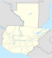

San Antonio La Paz San Antonio La Paz auf der Karte von Guatemala
Basisdaten Staat Guatemala Departamento El Progreso Einwohner 15.142 (2002) – im Ballungsraum 2.658 Detaildaten Fläche 209 km² Bevölkerungsdichte 72 Ew./km² Höhe 1.240 m Gewässer Río Las Cañas
Río PlátanosZeitzone UTC-6 Stadtpatron Antonius von Padua (Fest: 13. Juni) San Antonio La Paz ist ein rund 3.000 Einwohner zählender Ort und ein Municipio im Departamento El Progreso in Guatemala. Er liegt etwa 40 km nordöstlich von Guatemala-Stadt und 41 km südwestlich von Guastatoya auf 1240 m Höhe. Wenige Kilometer nordwestlich des Ortes verläuft die wichtige Atlantikfernstraße CA 9, die Guatemala-Stadt und Puerto Barrios verbindet. Von dort gibt es bei Kilometer 30 (Agua Caliente) und 36,5 Nebenstrecken nach San Antonio.
Das 209 km² große Municipio erstreckt sich im südwestlichen Bergland von El Progreso. Es hat insgesamt etwa 18.000 Einwohner, von denen ein Großteil in ländlichen Siedlungen und Dörfern lebt, darunter El Soyate, Hato, Las Navajas, Los Encinos, Jocotales, El Chorro, Los Planes, Los Amates, Las Moritas, El Naranjo, Llano Largo, Santo Domingo Los Ocotes, Agua Caliente, Estación Agua Caliente, El Suquinay, Los Astales, Prados de Canaan, Cucajol, Dolores, El Chile, El Carrizo und Santa Cruz Carrizo.
Im Osten und Norden trennt der Río Plátanos das Municipio vom benachbarten Municipio Sanarate, im Westen der Río Las Cañas vom Departamento Guatemala. Dort wo die Brücken der Atlantikfernstraße CA 9 und der nebenher verlaufenden Bahnstrecke den Río Las Cañas und damit die Grenze zwischen den Departamentos Guatemala und El Progeso überqueren, unterhält die Wohlfahrtseinrichtung IRTRA am Ostufer des Flusses, auf dem Gebiet des Municipios San Antonio La Paz, bei Agua Caliente, den Freizeitpark und das Thermalbad “Agua Caliente”.
Das Municipio San Antonio La Paz entstand im 19. Jahrhundert aus der Finca El Encinal und gehörte von 1835 bis 1908 und von 1920 bis 1934 zum Departamento Guatemala.
Siehe auch
Weblinks
- Offizielle Webseiten (Span.)
- IRTRA-Webseiten (Span.)

El Jícaro | Guastatoya | Morazán | Sanarate | Sansare | San Antonio La Paz | San Agustín Acasaguastlán | San Cristóbal Acasaguastlán
Wikimedia Foundation.
Schlagen Sie auch in anderen Wörterbüchern nach:
San Antonio (La Paz) — Saltar a navegación, búsqueda San Antonio de La Paz San Antonio … Wikipedia Español
San Antonio La Paz — is a municipality in the El Progreso department of Guatemala. It is situated at 1240m above sea level. It covers a terrain of 209km². San Antonio has great celebrationes for every holiday you can think of. San Antonio is home of many genirations… … Wikipedia
San Antonio La Paz — Administration Pays Guatemala … Wikipédia en Français
San Antonio La Paz — Original name in latin San Antonio La Paz Name in other language San Antonio La Paz State code GT Continent/City America/Guatemala longitude 14.74972 latitude 90.28667 altitude 1329 Population 7781 Date 2012 01 18 … Cities with a population over 1000 database
Municipio de San Antonio La Paz — Admin ASC 2 Code Orig. name Municipio de San Antonio La Paz Country and Admin Code GT.05.3590447 GT … World countries Adminstrative division ASC I-II
San Antonio — Saltar a navegación, búsqueda San Antonio puede referirse a: Contenido 1 Religión 1.1 Santos y beatos 1.1.1 Variante de nombre … Wikipedia Español
San Antonio (disambiguation) — San Antonio most commonly means the city of*San Antonio, TexasOther meanings include: Places Argentina *San Antonio, Jujuy (Jujuy Province) *San Antonio Department *San Antonio de Areco (Buenos Aires Province) *San Antonio Oeste (Río Negro… … Wikipedia
San Antonio de Senkata — Basisdaten Einwohner (Stand) 1274 Einw. (Fortschreibung 2009) [1] Höhe 3.945 m … Deutsch Wikipedia
San Antonio (Baja California Sur) — Saltar a navegación, búsqueda San Antonio es una pequeña ciudad en el estado mexicano de Baja California Sur, situado a pocos kilómetros al norte de Santiago sobre la carretera federal 1. Información Almirante Sebastián Vizcaíno bautiza en, 1596 … Wikipedia Español
San Antonio, Baja California Sur — San Antonio is a small town in the Mexican state of Baja California Sur, located a few miles north of Santiago on Federal Highway 1.InformationAdm. baptizes in Sebastian Vizcaino, 1596, as La Paz to the city is now the capital of the state of… … Wikipedia
San Antonio La Paz

18+
© Academic, 2000-2024
- Kontaktieren Sie uns: Unterstützung, Werbung
Wörterbücher Export, schritte mit PHP, Joomla, Drupal, WordPress, MODx.