- Sansare
-
14.747777777778-90.115833333333790Koordinaten: 14° 45′ N, 90° 7′ W
Sansare 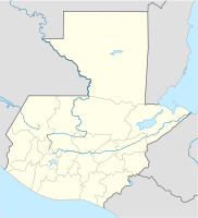

Sansare Sansare auf der Karte von Guatemala
Basisdaten Staat Guatemala Departamento El Progreso Einwohner 11.124 (2002) – im Ballungsraum 3.000 Detaildaten Fläche 118 km² Bevölkerungsdichte 94 Ew./km² Höhe 790 m Zeitzone UTC-6 Stadtpatron Virgen de las Mercedes Sansare ist ein rund 3.500 Einwohner zählender Ort und ein Municipio im Departamento El Progreso in Guatemala. Er liegt etwa 70 km nordöstlich von Guatemala-Stadt und 20 km südwestlich von Guastatoya auf 790 m Höhe. Der Ort liegt an der Nationalstraße 19, die in Monte Grande bei Sanarate von der Atlantikfernstraße CA 9 nach Südosten abzweigt und bis nach Jalapa und Jutiapa führt.
Das 118 km² große Municipio erstreckt sich im südlichen Hügelland von El Progreso. Es hat insgesamt etwa 13.000 Einwohner, von denen ein Großteil in ländlichen Siedlungen und Dörfern lebt, darunter Buena Vista, El Aguaje, El Llano, Estación Jalapa, La Montañita, Las Cabezas, La Trinidad, Los Cerritos, Poza Verde, Quebrada Grande, Río Grande Arriba, Río Grande Abajo, San Felipe Las Tablas, Santa Bárbara und El Juez.
Angrenzende Municipios sind Guastatoya im Norden und Sanarate im Westen. Im Süden und Osten grenzt Sansare an das Departamento Jalapa.
Das Municipio Sansare gehörte bis zum Jahr 1872 zum Departamento Guatemala und bis 1908 zu Jalapa.
Siehe auch
Weblinks
- Offizielle Webseiten (Span.)
- Dteillierte Informationen (Span.)

El Jícaro | Guastatoya | Morazán | Sanarate | Sansare | San Antonio La Paz | San Agustín Acasaguastlán | San Cristóbal Acasaguastlán
Wikimedia Foundation.
Schlagen Sie auch in anderen Wörterbüchern nach:
Sansare — Administration Pays Guatemala … Wikipédia en Français
Sansare — is a municipality in the El Progreso department of Guatemala. It is situated at 790 m above sea level. It contains 11,100 people. It covers a terrain of 118 km². The annual festival is September 23 September 25.External links* [ Muni in Spanish] … Wikipedia
Sansare — Original name in latin Sansare Name in other language Sansare State code GT Continent/City America/Guatemala longitude 14.74722 latitude 90.1125 altitude 787 Population 3792 Date 2012 01 18 … Cities with a population over 1000 database
Municipio de Sansare — Admin ASC 2 Code Orig. name Municipio de Sansare Country and Admin Code GT.05.3589553 GT … World countries Adminstrative division ASC I-II
El Progreso — Saltar a navegación, búsqueda Para otros usos de este término, véase El Progreso (desambiguación). El Progreso … Wikipedia Español
Guastatoya — Bandera … Wikipedia Español
Sanarate — 14.795 90.192222222222803 Koordinaten: 14° 48′ N, 90° 12′ W Sanarate … Deutsch Wikipedia
Guastatoya — 14.853888888889 90.068611111111515 Koordinaten: 14° 51′ N, 90° 4′ W … Deutsch Wikipedia
Liste Des Municipalités Du Guatemala — Carte du Guatemala indiquant sa division en municipalités. Le Guatemala est subdivisé en 323 municipalités, réparties entre 22 départements. Sommaire … Wikipédia en Français
Liste des municipalites du Guatemala — Liste des municipalités du Guatemala Carte du Guatemala indiquant sa division en municipalités. Le Guatemala est subdivisé en 323 municipalités, réparties entre 22 départements. Sommaire … Wikipédia en Français
Sansare

18+
© Academic, 2000-2024
- Kontaktieren Sie uns: Unterstützung, Werbung
Wörterbücher Export, schritte mit PHP, Joomla, Drupal, WordPress, MODx.