- Ureparapara
-
Ureparapara Banks-Inseln,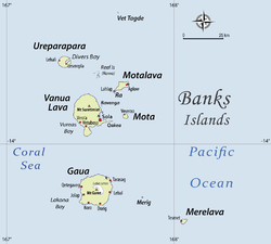
Ureparapara links obenGewässer Korallenmeer Inselgruppe Banks-Inseln Geographische Lage 13° 32′ 0″ S, 167° 20′ 0″ O-13.533333333333167.33333333333764Koordinaten: 13° 32′ 0″ S, 167° 20′ 0″ O 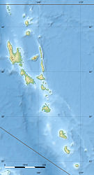

Länge 8,3 km Breite 7,7 km Fläche 39 km² Höchste Erhebung Mount Tow Lap
764 mEinwohner 437
11 Einw./km²Hauptort Leserepla Falschfarben-Satellitenbild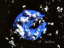
Ureparapara (früher Bligh Island) ist nach Gaua und Vanua Lava die drittgrößte Insel der Banks-Inseln im Norden des pazifischen Inselstaats Vanuatu, die verwaltungsmäßig zur Provinz Torba gehören.
Inhaltsverzeichnis
Geographie
Der alte vulkanische Krater der Insel wurde im Osten vom Meer erodiert, wodurch sich die Divers Bay (Lorup Bay) bildete. Abgesehen von dieser 3,7 km tiefen und 1,4 km breiten Einbuchtung ist die Insel annähernd kreisrund mit einem Durchmesser von rund acht Kilometern. Der höchste Punkt der Insel ist der Mount Tow Lap (Tooulap) mit 764 Metern, der auf dem Kraterrand liegt.
Die Insel ist 39 km² groß. 1979 zählte die Bevölkerung 239.[1] Neuere Quellen von 2009 nennen eine Bevölkerung von 437[2].
Es gibt drei Dörfer auf der Insel. Hauptort ist Léar (Léséréplag).[3] Die anderen sind Lehali (an der Westküste) und Lequanle (Lekwyangle, an der Nordwestküste).[4]
Sprachen
Auf der Insel werden zwei Sprachen gesprochen, Löyöp (im Hauptort Leserepla an der Divers Bay im Osten, 240 Sprecher) und Lehali (in den Dörfern Lehali und Lequanle im Westen und Nordwesten, 200 Sprecher).[5] Auf Lehali heißt die Insel Noypēypay [nɔjpejˈpaj], und auf Löyöp Aö [aˈø].
Weblinks
Einzelnachweise
- ↑ Unep Islands
- ↑ 2009 National Census of Population and Housing: Summary Release (PDF), Vanuatu National Statistics Office, 31-08-2009.
- ↑ Vincent Lebot und Pierre Cabalion: Les Kavas de Vanuatu, S. 83
- ↑ http://hbs.bishopmuseum.org/pi/pdf/17(4)-511.pdf Mario Maffi und Brian Taylor, The Mosquitoes Of The Banks And Torres Island Groups Of The South Pacific (Diptera: Culicidae)
- ↑ Detaillierte Liste und Karte der Banks- und Torres-Sprachen.
Vétaounde | Uréparapara | Rowa-Inseln | Mota Lava | Ra | Vanua Lava | Ravenga | Mota | Kwakéa | Niwula | Gaua | Mérig | Mere Lava
Wikimedia Foundation.
Schlagen Sie auch in anderen Wörterbüchern nach:
Ureparapara — Noypēypay, Aö Photographie satellite d’Ureparapara Géographie Pays … Wikipédia en Français
Ureparapara — (also known as Parapara for short and Noibaibai locally) is the third largest island in the Banks Group in northern Vanuatu. It is an old volcanic cone that has been breached by the sea on its east coast, forming Dives Bay.Two languages are… … Wikipedia
Урепарапара — англ. Ureparapara … Википедия
Islas Banks — (Banks Islands Îles Banks) Mapa de las islas Banks Localización geográfica / administrati … Wikipedia Español
Îles Banks — Pour les articles homonymes, voir Banks. Îles Banks Banks Islands (en) … Wikipédia en Français
Îles Rowa — Image satellite des îles Rowa. Géographie Pays … Wikipédia en Français
Vot Tande — Vet Tagde Carte des îles Banks. Vot Tande est au nord. Géographie Pays … Wikipédia en Français
Banks Islands — The Banks Islands (or Îles Banks) are a group of islands in northern Vanuatu. Together with the Torres Islands to the northwest, they make up the northernmost province of Torba. The group lies about 40 km north of Maewo, and includes Gaua and… … Wikipedia
Mota Lava — Motalava Native name: Mwotlap Mota Lava, viewed from space. On the southwest point one may see the islet of Ra … Wikipedia
Banks-Inseln (Vanuatu) — Banks Inseln Topographische Karte der Banks Inseln Gewässer Pazifischer Ozean … Deutsch Wikipedia
Ureparapara


18+
© Academic, 2000-2024
- Kontaktieren Sie uns: Unterstützung, Werbung
Wörterbücher Export, schritte mit PHP, Joomla, Drupal, WordPress, MODx.