- Addu-Atoll
-
Addu-Atoll Gewässer Indischer Ozean Archipel Malediven Geographische Lage 0° 38′ S, 73° 9′ O-0.6333333333333373.15Koordinaten: 0° 38′ S, 73° 9′ O 

Anzahl der Inseln 23 Hauptinsel Hithadhoo Landfläche 9,41 km² Lagunenfläche 76,71 km² Gesamtfläche 131,89 km² Einwohner 28000 Karte von Addu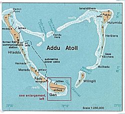
Das Addu-Atoll (Dhivehi: އައްޑުއަތޮޅު, administrativ: Seenu-Atoll, ސ) ist ein Atoll im Indischen Ozean. Es ist das südlichste Atoll der Malediven und liegt nur ein wenig südlich des Äquators. Die Gesamtfläche des Atolls beträgt 131,89 km². Davon entfallen 76,71 km² auf die Lagune, 9,41 km² auf die 23 Inseln, und der Rest auf die Riffplattform. Die Lagune ist bis zu 78,6 Meter tief. Eine Besonderheit des Addu-Atolls ist die Möglichkeit, sich auf dem Landweg über Dämme zwischen einigen Inseln des Atolls zu bewegen.
Die größten Inseln sind:
- Hithadhoo 3,6112 km²
- Gan 2,2561 km²
- Meedhoo 2,0495 km²
Das Atoll war seit 1941 zuerst Stützpunkt der Royal Navy, ab 1957 Stützpunkt der Royal Air Force. Die Marinebasis wurde auch von der Australian Imperial Force genutzt, während der Flughafen auf Gan Island vor allem als Zwischenstopp für Flugzeuge auf dem Weg nach Singapur diente. Von Gan Island wurden auch zahlreiche Raketen des Typs Kookaburra gestartet. 1971 wurde der Stützpunkt aufgegeben, Teile der Einrichtungen wurden in Quartiere für Touristen umgewandelt. Addu gilt als beliebtes Revier für Taucher.
Von 1959 bis 1963 bildete das Atoll, gemeinsam mit dem Huvadu-Atoll (damals Suvadiva genannt) und der Insel Fuvammulah im Süden der Malediven die international jedoch nicht anerkannte Vereinigte Republik Suvadiva.
Weblinks
- Informationen über Addu (englisch)
- Bilder von Addu auf flickr (englisch)
- Bericht über die Basis der Royal Navy (englisch)
- Reef Studies at Addu Atoll, Atoll Research Bulletin 116, 1964 (PDF-Datei; 5,28 MB)

von Nord nach Süd:
Ihavandhippolhu | Thiladhunmathi-Miladummadulhu (Boduthiladhunmathi) | Maamakunudhoo (Malcolm) | Alifushi (Powell Islands) | Nord-Maalhosmadulu | Fasdhūtherē (Middle Maalhosmadulu) | Süd-Maalhosmadulu | Faadhippolhu (Lhaviyani) | Goidu (Goifulhafehendhu / Horsburgh) | Kaashidhoo | Gaafaru | Nord-Malé | Süd-Malé | Toddu | Rasdhoo (Ross) | Ari | Felidhu | Vattaru | Mulaku (Meemu) | Nord-Nilandhe (Faafu) | Süd-Nilandhe (Dhaalu) | Kolhumadulhu (Thaa) | Haddhunmathi (Laamu) | Medutila (untermeerisch) | Huvadhu (Suvadiva) | Fuvammulah (Nyaviyani) | Addu (Seenu)
Wikimedia Foundation.
Schlagen Sie auch in anderen Wörterbüchern nach:
Addu Atoll — MaldiveAtoll ImageExists=Yes atoll admin name=Seenu Atoll atoll name=Addu Atoll location=0° 36 S and 0° 44 S letter=S abbreviation=S (ސ) capital=Hithadhoo population=28707 noofislands=23 inhabited islands=6 atoll chief = Saud Abdulla… … Wikipedia
Villingili (Addu-Atoll) — Vorlage:Infobox Insel/Wartung/Bild fehltVorlage:Infobox Insel/Wartung/Fläche fehltVorlage:Infobox Insel/Wartung/Höhe fehlt Villingili (Addu Atoll) Gewässer Indischer Ozean Inselgruppe Addu Atoll … Deutsch Wikipedia
Addu Kandu — Addu Kandu, Dv. for Addu Channel , is the traditional name of the broad channel between Huvadhu Atoll and Addu Atoll in the south of Maldives. In the British Admiralty charts it is called Equatorial Channel because the Equator passes through its… … Wikipedia
Atoll Nilandhe Nord — ނިލަންދެއަތޮޅު އުތުރުބުރި (dv) Carte de l atoll Nilandhe Nord. Géographie Pays … Wikipédia en Français
Atoll Faadhippolhu — ފާދިއްޕޮޅު (dv) Carte de l atoll Faadhippolhu. Géographie Pays … Wikipédia en Français
Atoll Hadhdhunmathi — ހައްދުންމަތި (dv) Carte de l atoll Hadhdhunmathi. Géographie Pays … Wikipédia en Français
Atoll Kolhumadulu — ކޮޅުމަޑުލު (dv) Carte de l atoll Kolhumadulu. Géographie Pays … Wikipédia en Français
Atoll Mulaku — މުލަކަތޮޅު (dv) Carte de l atoll Mulaku. Géographie Pays … Wikipédia en Français
Atoll Nilandhe Sud — ނިލަންދެއަތޮޅު ދެކުނުބުރި (dv) Carte de l atoll Nilandhe Sud. Géographie Pays … Wikipédia en Français
Atoll Ari — Image satellite de l atoll Ari avec l atoll Rasdu en haut à droite. Géographie Pays … Wikipédia en Français
- Kontaktieren Sie uns: Unterstützung, Werbung
Addu-Atoll


18+
© Academic, 2000-2024
Wörterbücher Export, schritte mit PHP, Joomla, Drupal, WordPress, MODx.