- Masaka
-
Karte 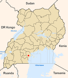
Lage von Masaka innerhalb Ugandas
Basisdaten Distrikt Masaka Geographische Lage 0° 19′ S, 31° 43′ O-0.3166666666666731.7166666666671335Koordinaten: 0° 19′ S, 31° 43′ O Fläche ? Einwohnerzahl 71.700 (Schätzung 2008) Bevölkerungsdichte ? Einwohner/km² mittlere Höhe 1.335 m Niederschlag ? mm/a Zeitzone UTC +3 UN/LOCODE UG MSK Telefonvorwahl (+256) 0481 Masaka ist eine Stadt im Süden Ugandas nahe dem Viktoriasee sowie dem Nabugabo-See mit rd. 75.000 Einwohnern. Sie ist die Hauptstadt des gleichnamigen Distrikts Masaka und liegt südlich des Äquators an der Fernstraße von Kampala (ca. 140 km) nach Mbarara und Ruanda. Der nächstgelegene Hafen am Viktoriasee ist das östlich gelegene und rund 40 km entfernte Bukakata (Fähre zu den Ssese Islands).
Masaka ist seit 1953 Sitz des römisch-katholischen Bistums Masaka, hat aber eine religiös gemischte Bevölkerung (Christen, Muslime).
1979 wurde die Stadt beim Einmarsch tansanischer Truppen, die an der Vertreibung Idi Amins beteiligt waren, stark zerstört, was man noch heute an manchen Stellen im Stadtbild sehen kann.
Bevölkerungsentwicklung
Jahr Einwohner Zensus 1911 Zensus 1921 Zensus 1931 Zensus 1940 Zensus 1959 5.000 Zensus 1969 Zensus 1980 Zensus 1991 49.585 Zensus 2002 67.768 Schätzung 2008 71.700 Einzelnachweise
Kategorie:- Ort in Uganda

Wikimedia Foundation.