- Washington County (Indiana)
-
Verwaltung US-Bundesstaat: Indiana Verwaltungssitz: Salem Adresse des
Verwaltungssitzes:County Courthouse
99 Public Square
Salem, IN 47167-2042Gründung: 21. Dezember 1813 Gebildet aus: Clark County
Harrison County
Jefferson CountyVorwahl: 001 812 Demographie Einwohner: 27.920 (2007) Bevölkerungsdichte: 20,9 Einwohner/km² Geographie Fläche gesamt: 1.338 km² Wasserfläche: 5 km² Karte 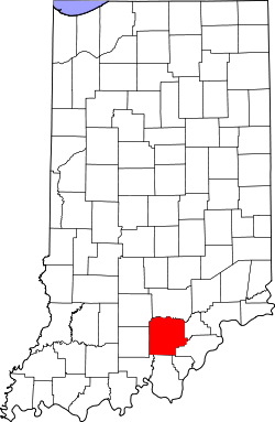
Website: www.washingtoncountyindiana.com Washington County[2] ist ein County im US-Bundesstaat Indiana der Vereinigten Staaten von Amerika. Der Verwaltungssitz (County Seat) ist Salem. Laut einer offiziellen Schätzung von 2007 besitzt das County eine Einwohnerzahl von 27.920 mit einer Bevölkerungsdichte von 20,9 Einwohner/km².
Inhaltsverzeichnis
Geografie
Das County liegt im Süden von Indiana, ist im Südosten etwa 35 km von Kentucky entfernt und hat eine Fläche von 1338 Quadratkilometern, wovon 5 Quadratkilometer Wasserfläche sind. Es grenzt im Uhrzeigersinn an folgende Countys: Jackson County, Scott County, Clark County, Floyd County, Harrison County, Crawford County, Orange County und Lawrence County.
Geschichte
Washington County wurde am 21. Dezember 1813 aus Teilen des Clark County, Harrison County und des Jefferson County gebildet. Benannt wurde es nach George Washington, dem Oberbefehlshaber der Kontinentalarmee im Amerikanischen Unabhängigkeitskrieg und späteren ersten US-Präsidenten.
Demografische Daten
Historische Einwohnerzahlen Census Einwohner ± in % 1810 3595 — 1820 7875 100 % 1830 10.273 30 % 1840 12.459 20 % 1850 15.286 20 % 1860 18.521 20 % 1870 19.913 8 % 1880 21.326 7 % 1890 20.786 -3 % 1900 19.409 -7 % 1910 17.445 -10 % 1920 16.645 -5 % 1930 16.285 -2 % 1940 17.008 4 % 1950 16.520 -3 % 1960 17.819 8 % 1970 19.278 8 % 1980 21.932 10 % 1990 23.717 8 % 2000 27.223 10 % Vor 1900[3] 1900–1990[4]
Nach einer Schätzung im Jahr 2006[5] lebten hier 28.062 Menschen in 10.264 Haushalten und 7.585 Familien. Die Bevölkerungsdichte betrug 20 Einwohner pro Quadratkilometer. Ethnisch betrachtet setzte sich die Bevölkerung zusammen aus 98,75 Prozent Weißen, 0,13 Prozent Afroamerikanern, 0,13 Prozent amerikanischen Ureinwohnern, 0,16 Prozent Asiaten, 0,01 Prozent Bewohnern aus dem pazifischen Inselraum und 0,24 Prozent aus anderen ethnischen Gruppen; 0,58 Prozent stammten von zwei oder mehr Ethnien ab. 0,73 Prozent der Bevölkerung waren spanischer oder lateinamerikanischer Abstammung.
Von den 10.264 Haushalten hatten 35,0 Prozent Kinder unter 18 Jahre, die mit ihnen im Haushalt lebten. 60,2 Prozent waren verheiratete, zusammenlebende Paare, 9,2 Prozent waren allein erziehende Mütter und 26,1 Prozent waren keine Familien. 22,2 Prozent waren Singlehaushalte und in 9,0 Prozent lebten Menschen mit 65 Jahren oder darüber. Die Durchschnittshaushaltsgröße betrug 2,62 und die durchschnittliche Familiengröße lag bei 3,05 Personen.
26,5 Prozent der Bevölkerung waren unter 18 Jahre alt, 8,7 Prozent zwischen 18 und 24, 29,7 Prozent zwischen 25 und 44 Jahre. 23,0 Prozent zwischen 45 und 64 und 12,0 Prozent waren 65 Jahre alt oder älter. Das Durchschnittsalter betrug 36 Jahre. Auf 100 weibliche Personen kamen 100,1 männliche Personen. Auf 100 Frauen im Alter von 18 Jahren und darüber kamen 97,2 Männer.
Das jährliche Durchschnittseinkommen eines Haushalts betrug 36.630 USD, das Durchschnittseinkommen der Familien 42.618 USD. Männer hatten ein Durchschnittseinkommen von 29.929 USD, Frauen 21.944 USD. Das Prokopfeinkommen betrug 16.748 USD. 7,3 Prozent der Familien und 10,6 Prozent der Bevölkerung lebten unterhalb der Armutsgrenze.
Einzelnachweise
- ↑ Auszug aus dem National Register of Historic Places. Abgerufen am 13. März 2011
- ↑ GNIS-ID: 451665. Abgerufen am 22. Februar 2011 (englisch).
- ↑ U.S. Census Bureau - Census of Population and Housing. Abgerufen am 15. März 2011
- ↑ Auszug aus Census.gov. Abgerufen am 16. Februar 2011
- ↑ http://www.census.gov/ Die Einwohnerzahlen sind laut dem United States Census Bureau nur geschätzt. Sie basieren nicht auf einer Zählung.
Siehe auch

Liste der Countys in Indiana
Adams | Allen | Bartholomew | Benton | Blackford | Boone | Brown | Carroll | Cass | Clark | Clay | Clinton | Crawford | Daviess | DeKalb | Dearborn | Decatur | Delaware | Dubois | Elkhart | Fayette | Floyd | Fountain | Franklin | Fulton | Gibson | Grant | Greene | Hamilton | Hancock | Harrison | Hendricks | Henry | Howard | Huntington | Jackson | Jasper | Jay | Jefferson | Jennings | Johnson | Knox | Kosciusko | LaGrange | Lake | LaPorte | Lawrence | Madison | Marion | Marshall | Martin | Miami | Monroe | Montgomery | Morgan | Newton | Noble | Ohio | Orange | Owen | Parke | Perry | Pike | Porter | Posey | Pulaski | Putnam | Randolph | Ripley | Rush | St. Joseph | Scott | Shelby | Spencer | Starke | Steuben | Sullivan | Switzerland | Tippecanoe | Tipton | Union | Vanderburgh | Vermillion | Vigo | Wabash | Warren | Warrick | Washington | Wayne | Wells | White | Whitley
Wikimedia Foundation.
Schlagen Sie auch in anderen Wörterbüchern nach:
Washington Township, Washington County, Indiana — Infobox Settlement official name = Washington Township settlement type = Township nickname = motto = imagesize = image caption = image mapsize = map caption = mapsize1 = map caption1 = subdivision type = Country subdivision name = United States… … Wikipedia
Washington County, Indiana — Infobox U.S. County county = Washington County state = Indiana map size = 150 founded = 1814 seat = Salem | area total sq mi =517 area water sq mi =2 area percentage = 0.41% census yr = 2000 pop = 27223 density km2 =20 web =… … Wikipedia
National Register of Historic Places listings in Washington County, Indiana — Location of Washington County in Indiana This is a list of the National Register of Historic Places listings in Washington County, Indiana. This is intended to be a complete list of the properties and districts on the National Register of… … Wikipedia
Monroe Township, Washington County, Indiana — Monroe Township Township Location in Washington County … Wikipedia
Brown Township, Washington County, Indiana — Infobox Settlement official name = Brown Township settlement type = Township nickname = motto = imagesize = image caption = image mapsize = map caption = mapsize1 = map caption1 = subdivision type = Country subdivision name = United States… … Wikipedia
Franklin Township, Washington County, Indiana — Infobox Settlement official name = Franklin Township settlement type = Township nickname = motto = imagesize = image caption = image mapsize = map caption = mapsize1 = map caption1 = subdivision type = Country subdivision name = United States… … Wikipedia
Gibson Township, Washington County, Indiana — Infobox Settlement official name = Gibson Township settlement type = Township nickname = motto = imagesize = image caption = image mapsize = map caption = mapsize1 = map caption1 = subdivision type = Country subdivision name = United States… … Wikipedia
Howard Township, Washington County, Indiana — Infobox Settlement official name = Howard Township settlement type = Township nickname = motto = imagesize = image caption = image mapsize = map caption = mapsize1 = map caption1 = subdivision type = Country subdivision name = United States… … Wikipedia
Jackson Township, Washington County, Indiana — Infobox Settlement official name = Jackson Township settlement type = Township nickname = motto = imagesize = image caption = image mapsize = map caption = mapsize1 = map caption1 = subdivision type = Country subdivision name = United States… … Wikipedia
Jefferson Township, Washington County, Indiana — Infobox Settlement official name = Jefferson Township settlement type = Township nickname = motto = imagesize = image caption = image mapsize = map caption = mapsize1 = map caption1 = subdivision type = Country subdivision name = United States… … Wikipedia
Washington County (Indiana)


18+
© Academic, 2000-2024
- Kontaktieren Sie uns: Unterstützung, Werbung
Wörterbücher Export, schritte mit PHP, Joomla, Drupal, WordPress, MODx.