- Bogoslof Island
-
Bogoslof Island Luftaufnahme von Bogoslof Island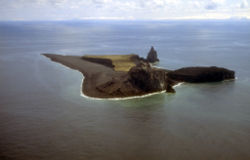
Gewässer Beringmeer Inselgruppe Aleuten (Alaska) Geographische Lage 53° 56′ 9″ N, 168° 2′ 20″ W53.9358333-168.0388889150Koordinaten: 53° 56′ 9″ N, 168° 2′ 20″ W 

Länge 2 km Breite 750 m Fläche ,75 km² Höchste Erhebung Castle Rock
150 mEinwohner (unbewohnt) Bogoslof Island ist eine kleine unbewohnte Vulkaninsel der Fox Islands, die zu den Aleuten gehören. Das etwa 2 km lange und 0,75 km² große Eiland liegt nördlich von Umnak.
Bogoslof Island ist die Spitze eines submarinen Vulkans, der 1500 Meter über dem Boden der Beringsee aufragt. Der Vulkan ist in historischer Zeit mehrfach ausgebrochen, die Eruptionen haben die Insel immer wieder verschwinden und an anderen Stellen auftauchen lassen, was zu einer verwirrenden Namensgebung geführt hat. Die gegenwärtige Insel ist der Überrest des Lavadoms der Ausbrüche von 1796 bis 1992. Fire Island, etwa 800 Meter nordwestlich, ist ein Überrest der Eruption von 1883.
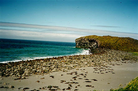
 Seelöwenkolonie am Strand von Bogoslof
Bereits 1907 wurde das Eiland von Theodore Roosevelt mit der benachbarten Fire Island als besonderes Schutzgebiet für Seelöwen und Seevögel ausgezeichnet. Zusammen mit Fire gehört Bogoslof zum Alaska Maritime National Wildlife Refuge. Im November 1967 erhob der National Park Service die Insel zum National Natural Landmark. [1]
Einzelnachweise
- ↑ National Natural Landmark: Bogoslof Island auf nps.gov
Weblinks
 Commons: Bogoslof Island – Sammlung von Bildern, Videos und Audiodateien
- Bogoslof Island im Geographic Names Information System des United States Geological Survey
- Beschreibung des Alaska Volcano Observatory (englisch)
- Bogoslof Island im Global Volcanism Program der Smithsonian Institution (englisch)
Inseln der Fox IslandsAmak | Amaknak | Ananiuliak | Bird | Bogoslof | Breadloaf | Buck | Caton | Chagulak | Deer | Dushkot | Egg | Emerald | Expedition | Fire | Gargoyle | Gull | Hog | Kigul | Krenitzin | Kudiakof | Ogangen | Ogchul | Pancake Rock | Peter | Poa | Pustoi | The Signals | Samalga | Sanak | Sedanka | Sushilnoi | Tangik | Tanginak | Umnak | Unalaska | Unalga | Unimak | Vsevidof | Wislow
Wikimedia Foundation.
Schlagen Sie auch in anderen Wörterbüchern nach:
Bogoslof Island — (Aĝasaaĝux̂ [Bergsland, K Aleut Dictionary Fairbanks: Alaska Native Language Center, 1994] ) is the summit of a largely submarine stratovolcano located in the Bering Sea in the U.S. state of Alaska, 50 km (31 mi) behind the main Aleutian volcanic … Wikipedia
Bogoslof Wilderness — Infobox protected area | name = Bogoslof Wilderness iucn category = Ib caption = Bogoslof Island locator x = locator y = location = Aleutians West Census Area, Alaska, USA nearest city = Unalaska, Alaska lat degrees = lat minutes = lat seconds =… … Wikipedia
Île Bogoslof — Vue aérienne de l île Bogoslof Géographie Pays … Wikipédia en Français
Fire Island (Aleutian Islands) — Fire Island is located in the eastern Aleutian Islands at coord|53|56|N|168|2|W. It emerged in 1883, forming a companion island to Bogoslof Island. Originally, this Fire Island was named New Bogoslof (also Grewingk, after an Alaskan geologist).In … Wikipedia
Ile Bogoslof — Île Bogoslof Île Bogoslof Vue aérienne de l île Bogoslof Géographie Pays … Wikipédia en Français
Fire Island (Aleuten) — Vorlage:Infobox Insel/Wartung/Bild fehltVorlage:Infobox Insel/Wartung/Fläche fehltVorlage:Infobox Insel/Wartung/Höhe fehlt Fire Island Gewässer Pazifischer Ozean Inselgruppe Aleuten … Deutsch Wikipedia
Unalaska Island — Unalaska ist eine Insel der Fox Islands in der Mitte der Aleuten, südwestlich von Alaska in den Vereinigten Staaten. Die Insel ist 2721 km² (1051 Quadratmeilen) groß. Im Nordosten, der Beringsee zugewandten Seite der Insel liegt die Stadt… … Deutsch Wikipedia
Fire Island, Alaska — There are three islands named Fire Island in the U.S. state of Alaska.Different IslandsIn the Kashevarof PassageOne is convert|0.1|mi|km long (160 m) and located in Kashevarof Passage, off the north coast of Prince of Wales Island, at… … Wikipedia
Nunivak Island — Nunivak Maskette – Nunivak … Wikipedia
Medny Island — Map showing position of Commander Islands to the east of Kamchatka. The smaller island in the east is Medny and the larger island is Bering Island. Medny Island (also spelled Mednyy, Russian: остров Медный, sometimes called Copper Island in… … Wikipedia
Bogoslof Island


18+
© Academic, 2000-2024
- Kontaktieren Sie uns: Unterstützung, Werbung
Wörterbücher Export, schritte mit PHP, Joomla, Drupal, WordPress, MODx.