- Dauan
-
Dauan Island Landsat-Bild von Dauan Island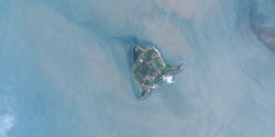
Gewässer Pazifischer Ozean Inselgruppe Torres-Strait-Inseln Geographische Lage 9° 25′ 22″ S, 142° 32′ 8″ O-9.4227444444444142.53560833333272Koordinaten: 9° 25′ 22″ S, 142° 32′ 8″ O Länge 2,8 km Breite 2,6 km Fläche 3,72 km² Höchste Erhebung Mount Cornwallis
272 mEinwohner 153 (2006)
41 Einw./km²Lage der Torres-Strait-Inseln:
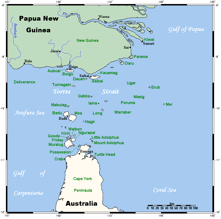
Dauan Island oben, Mitte.Dauan Island ist eine kleine Granitinsel der Torres-Strait-Inseln nahe dem Festland von Papua-Neuguinea. Sie zählt mit der 30 km nordwestlich gelegenen Insel Boigu und der 6 km östlich gelegenen Insel Saibai verwaltungstechnisch zu den Top Western Islands, einer Inselregion im Verwaltungsbezirk Torres Shire.
Geographisch liegt auf der etwa 4 km² großen Insel der nördlichste Berg der australischen Great Dividing Range, dem größten Gebirgszug des Kontinentes. Höchster Gipfel ist der zentral gelegene Mount Cornwallis (272 m).
Nach dem Zensus von 2006 hatte Dauan 153 Einwohner, nach 120 im Jahr 2001. Die Ansiedlung erfolgte an einem schmalen Küstenstreifen vor dem Hintergrund steiler Anhöhen. Es gibt keine Start- und Landebahn für Flugzeuge auf der Insel, daher ist die Anreise nur per Boot oder Hubschrauber möglich.
Siehe auch
Weblinks
Inselregionen, Hauptinseln und Inselgruppen im Archipel der Torres-Strait-Inselnzu Papua-Neuguinea gehörige Torres-Strait-Inseln: Bristow Island | Daru Island | Parama Island • Kawai-Inseln | Talbot-Inseln
Top Western: Boigu | Dauan | Deliverance | Saibai | Turnagain • Talbot-Inseln
Western: Badu | Mabuiag | Moa | Portlock | Tobin • Bellevue-Inseln | Duncan-Inseln | Farewell-Inseln | Kulbi-Inseln
Central: Aureed | Bourke | Coconut | Sassie | Sue | Yam | Yorke • Bourke-Inseln | The Three Sisters | Yorke-Inseln
Eastern: Bramble | Darnley | Murray | Stephens • Murray-Inseln
Inner: Albany | Booby | Crab | Entrance | Friday | Goods | Hammond | Horn | Packe | Port Lihou | Prince-of-Wales | Thursday | Wednesday • Manar-Inseln | Red-Wallis-Inseln | Thursday-Inseln | Tuesday-Inseln
Wikimedia Foundation.
Schlagen Sie auch in anderen Wörterbüchern nach:
Birds of Boigu, Saibai and Dauan Islands (Torres Strait) — The Birds of Boigu, Saibai and Dauan Islands (the Top Western group of Torres Strait), are of particular interest to Australian birders because the islands are home to, and visited by, birds which are essentially New Guinea species not found, or… … Wikipedia
DAJ — Dauan Island, Queensland, Australia (Regional » Airport Codes) ** Daimler Benz, A. G. (now DCX = Daimler Chrysler) (Business » NYSE Symbols) … Abbreviations dictionary
Torres Strait Islands — The Torres Strait Islands are a group of at least 274 small islands which lie in Torres Strait, the waterway separating far northern continental Australia s Cape York Peninsula and the island of New Guinea. They are part of Queensland, a… … Wikipedia
Torres Strait Islands Regional Council — Infobox Australian Place | type = lga name = Torres Strait Islands Region state = qld caption = pop = 4,298 (2006 census) area = 491.1 est = 2008 seat = Thursday Island mayor = Cr Fred Gela region = Far North Queensland logosize = url = stategov … Wikipedia
Territorial waters — Schematic map of maritime zones. Territorial waters, or a territorial sea, as defined by the 1982 United Nations Convention on the Law of the Sea,[1] is a belt of coastal waters extending at most 12 nautical miles (22 km; 14 mi) from… … Wikipedia
Kala Lagaw Ya — Infobox Language name=Kala Lagaw Ya/Kalau Kawau Ya/Kulkalgau Ya/Kawalgau Ya Lagau Ya region=Western and Central Torres Strait Islands, Queensland speakers=3000–4000 familycolor=Australian fam1=Pama Nyungan iso3=mwpKala Lagaw Ya (correctly Kalaw… … Wikipedia
Boigu Island (Queensland) — Boigu Island (coord|9|16|S|142|13|E|region:AU QLD type:isle|display=inline,title) is the most northerly inhabited island in Australian territory. It is part of the top western group of the Torres Strait Islands, which lie in the Torres Strait… … Wikipedia
Yam Island (Queensland) — Yam Island (Iama Island) is an island in the Bourke Isles, 100km North East of Thursday Island Queensland, Australia in the Tancred Passage Torres Strait.This island is one of the Torres Strait Islands. Its indigenous language is Kulkalgau Ya, a… … Wikipedia
Aipus — Bellevue Inseln Lage der Torres Strait Inseln Gewässer Pazifischer Ozean Anzahl der Inseln 12 … Deutsch Wikipedia
Albany Island (Queensland) — w1 Albany Island Lage der Torres Strait Inseln Gewässer Pazifischer Ozean Inselgruppe … Deutsch Wikipedia
Dauan

18+
© Academic, 2000-2024
- Kontaktieren Sie uns: Unterstützung, Werbung
Wörterbücher Export, schritte mit PHP, Joomla, Drupal, WordPress, MODx.