- Goodhue County
-
 Das Goodhue County Courthouse in Red Wing
Verwaltung US-Bundesstaat: Minnesota Verwaltungssitz: Red Wing Adresse des
Verwaltungssitzes:Justice Center/Court Administration
454 W. 6th Street
Red Wing, MN 55066-2540Gründung: 3. März 1853 Gebildet aus: Dakota County
Wabasha CountyVorwahl: 001 651 Demographie Einwohner: 46.183 (2010) Bevölkerungsdichte: 23,5 Einwohner/km² Geographie Fläche gesamt: 2.021 km² Wasserfläche: 57 km² Karte 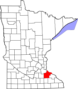
Website: www.co.goodhue.mn.us Das Goodhue County[1] ist ein County im US-amerikanischen Bundesstaat Minnesota. Bei der Volkszählung im Jahr 2010 hatte das County 46.183 Einwohner und eine Bevölkerungsdichte von 23,5 Einwohnern pro Quadratkilometer. Der Verwaltungssitz (County Seat) ist Red Wing, das nach einem Dakota-Häuptling benannt wurde.
Inhaltsverzeichnis
Geografie
Das County liegt im Südosten von Minnesota, grenzt im Nordosten an Wisconsin, wobei der Mississippi die natürliche Grenze bildet und hat eine Fläche von 2021 Quadratkilometern, wovon 57 Quadratkilometer Wasserfläche sind. Es grenzt an folgende Countys:
Dakota County Pierce County (Wisconsin),
Pepin County (Wisconsin)Rice County 
Wabasha County Dodge County Olmsted County Geschichte
Das Goodhue County wurde am 3. März 1853 aus Teilen des Dakota County und des Wabasha County gebildet. Benannt wurde es nach James Madison Goodhue, dem Herausgeber einer Zeitung.
Demografische Daten
Historische Einwohnerzahlen Census Einwohner ± in % 1860 8977 — 1870 22.618 200 % 1880 29.651 30 % 1890 28.806 -3 % 1900 31.137 8 % 1910 31.637 2 % 1920 30.799 -3 % 1930 31.317 2 % 1940 31.564 0,8 % 1950 32.118 2 % 1960 33.035 3 % 1970 34.763 5 % 1980 38.749 10 % 1990 40.690 5 % 2000 44.127 8 % 2010 46.183 5 % Vor 1900[2] 1900–1990[3] 2000[4] 2010[5] Nach der Volkszählung im Jahr 2000 lebten im Goodhue County 44.127 Menschen in 16.983 Haushalten und 11.905 Familien. Die Bevölkerungsdichte betrug 22 Einwohner pro Quadratkilometer. Ethnisch betrachtet setzte sich die Bevölkerung zusammen aus 96,57 Prozent Weißen, 0,63 Prozent Afroamerikanern, 0,98 Prozent amerikanischen Ureinwohnern, 0,57 Prozent Asiaten, 0,03 Prozent Bewohnern aus dem pazifischen Inselraum und 0,53 Prozent aus anderen ethnischen Gruppen; 0,69 Prozent stammten von zwei oder mehr Ethnien ab. 1,07 Prozent der Bevölkerung waren spanischer oder lateinamerikanischer Abstammung, die verschiedenen der genannten Gruppen angehörten.
Von den 16.983 Haushalten hatten 33,8 Prozent Kinder unter 18 Jahren, die bei ihnen lebten. 59,2 Prozent davon waren verheiratete, zusammenlebende Paare. 7,2 Prozent waren alleinerziehende Mütter und 29,9 Prozent waren keine Familien. 25,2 Prozent waren Singlehaushalte und in 11,5 Prozent der Haushalte lebten alleinstehende Menschen im Alter von 65 Jahren oder darüber. Die Durchschnittshaushaltsgröße lag bei 2,53 Personen, die durchschnittliche Familiengröße bei 3,04 Personen.
26,5 Prozent der Bevölkerung waren unter 18 Jahre alt. 7,4 Prozent waren zwischen 18 und 24, 27,9 Prozent zwischen 25 und 44, 23,2 Prozent zwischen 45 und 64 und 15,0 Prozent waren älter als 65 Jahre. Das Durchschnittsalter betrug 38 Jahre. Auf 100 weibliche kamen statistisch 98,1 männliche Personen. Auf 100 Frauen im Alter von 18 Jahren oder darüber kamen 95,4 Männer.
Das jährliche Durchschnittseinkommen eines Haushalts betrug 46.972 USD und das Durchschnittseinkommen einer Familie betrug 55.689 USD. Männer hatten ein Durchschnittseinkommen von 36.282 USD, Frauen 25.442 USD. Das Pro - Kopf - Einkommen betrug 21.934 USD. 3,7 Prozent der Familien und 5,7 Prozent der Einwohner lebten unterhalb der Armutsgrenze.[6]
Städte und Gemeinden
- Bellechester1
- Cannon Falls
- Dennison2
- Goodhue
- Wanamingo
- Zumbrota
1 - teilweise im Wabasha County
2 - teilweise im Rice County
3 - teilweise im Olmsted CountyEinzelnachweise
- ↑ GNIS-ID: 659470. Abgerufen am 22. Februar 2011 (englisch).
- ↑ U.S. Census Bureau - Census of Population and Housing Abgerufen am 15. März 2011
- ↑ Auszug aus Census.gov Abgerufen am 18. Februar 2011
- ↑ Auszug aus factfinder.census.gov Abgerufen am 18. Februar 2011
- ↑ United States Census 2010 Abgerufen am 26. Juli 2011
- ↑ Goodhue County, Minnesota Datenblatt mit den Ergebnissen der Volkszählung im Jahre 2000 bei factfinder.census.gov
Weblinks
-
 Commons: Goodhue County, Minnesota – Sammlung von Bildern, Videos und Audiodateien
 - Offizielle Webseite
- www.city-data.com

Liste der Countys in Minnesota
Aitkin | Anoka | Becker | Beltrami | Benton | Big Stone | Blue Earth | Brown | Carlton | Carver | Cass | Chippewa | Chisago | Clay | Clearwater | Cook | Cottonwood | Crow Wing | Dakota | Dodge | Douglas | Faribault | Fillmore | Freeborn | Goodhue | Grant | Hennepin | Houston | Hubbard | Isanti | Itasca | Jackson | Kanabec | Kandiyohi | Kittson | Koochiching | Lac qui Parle | Lake | Lake of the Woods | Le Sueur | Lincoln | Lyon | Mahnomen | Marshall | Martin | McLeod | Meeker | Mille Lacs | Morrison | Mower | Murray | Nicollet | Nobles | Norman | Olmsted | Otter Tail | Pennington | Pine | Pipestone | Polk | Pope | Ramsey | Red Lake | Redwood | Renville | Rice | Rock | Roseau | Scott | Sherburne | Sibley | St. Louis | Stearns | Steele | Stevens | Swift | Todd | Traverse | Wabasha | Wadena | Waseca | Washington | Watonwan | Wilkin | Winona | Wright | Yellow Medicine
Wikimedia Foundation.
Schlagen Sie auch in anderen Wörterbüchern nach:
Goodhue County — Admin ASC 2 Code Orig. name Goodhue County Country and Admin Code US.MN.049 US … World countries Adminstrative division ASC I-II
County roads in Goodhue County, Minnesota — The following is an incomplete list of county maintained roads in Goodhue County, Minnesota, United States.[1] Contents 1 County Road 1 2 County Road 2 3 County Ro … Wikipedia
Goodhue County, Minnesota — Infobox U.S. County county = Goodhue County state = Minnesota founded year = 1853 [http://www.house.leg.state.mn.us/hinfo/govseries/No32.htm] founded date = March 5 seat wl = Red Wing largest city wl = Red Wing area total sq mi = 780 area total… … Wikipedia
Goodhue Township, Goodhue County, Minnesota — Infobox Settlement official name = Goodhue Township, Minnesota settlement type = Township nickname = motto = imagesize = image caption = image |pushpin pushpin label position =left pushpin map caption =Location within the state of Minnesota… … Wikipedia
National Register of Historic Places listings in Goodhue County, Minnesota — Map of all coordinates from Google Map of all coordinates from Bing … Wikipedia
Cherry Grove Township, Goodhue County, Minnesota — Cherry Grove Township, Minnesota Township … Wikipedia
Minneola Township, Goodhue County, Minnesota — Minneola Township, Minnesota Township Minneola Town Hall seen from U.S. Highway 52 … Wikipedia
List of Registered Historic Places in Goodhue County, Minnesota — This is a complete List of Registered Historic Places in Goodhue County, Minnesota. The list includes 59 entries on the National Register of Historic Places.Goodhue County is a county located in the southeastern part of the U.S. state of… … Wikipedia
Wacouta Township, Goodhue County, Minnesota — Infobox Settlement official name = Wacouta Township, Minnesota settlement type = Township nickname = motto = imagesize = image caption = image |pushpin pushpin label position =left pushpin map caption =Location within the state of Minnesota… … Wikipedia
Vasa Township, Goodhue County, Minnesota — Infobox Settlement official name = Vasa Township, Minnesota settlement type = Township nickname = motto = imagesize = image caption = image |pushpin pushpin label position =left pushpin map caption =Location within the state of Minnesota pushpin… … Wikipedia
Goodhue County


18+
© Academic, 2000-2024
- Kontaktieren Sie uns: Unterstützung, Werbung
Wörterbücher Export, schritte mit PHP, Joomla, Drupal, WordPress, MODx.