Povoação Velha

Povoação Velha
Povoação Velha
Povoação Velha (Kap Verde)
Povoação Velha
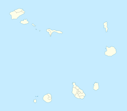
Povoação Velha
Basisdaten
Staat Kap Verde
Inselgruppe Ilhas de Barlavento
Distrikt Boa Vista
Einwohner 300 (1. Januar 2004)
ISO 3166-2 CV-BV
Dorfplatz
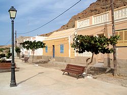
Dorfplatz
16.033333333333-22.916666666667
Nossa Senhora da Conceição
Blick über den Ort

Povoação Velha (in kapverdischem Kreol [ALUPEC]: Povoason Bédja) ist eine Ortschaft im Südwesten der Insel Boa Vista von Kap Verde, etwa 25 Kilometer südlich der Inselhauptstadt Sal Rei und 15 Kilometer südlich von Rabil.

Povoação Velha hat ungefähr 300 Einwohner. Es ist der älteste Ort auf der Insel. Die Kirche Nossa Senhora da Conceição stammt aus dem Jahr 1828.

Der Ort gilt als ärmster der Insel.

Weblinks

 Commons: Povoação Velha – Sammlung von Bildern, Videos und Audiodateien

Wikimedia Foundation.

Игры ⚽ Нужно сделать НИР?

Schlagen Sie auch in anderen Wörterbüchern nach:

  • Povoação Velha — For the town in the Azores, see Povoação Povoação Velha (Capeverdean Crioulo, (written in ALUPEC): Povoason Bédja ) is a village in the southwestern part of the island of Boa Vista. The village is around 25 km southeast of the island capital of… …   Wikipedia

  • Curral Velho, Cape Verde — Curral Velho Kurral Bedju or Kurral Bédj Statistics Island: Boa Vista Municipality: Boa Vista Location: Latitude: Longitude: 15.9833 (15° 59 ) N …   Wikipedia

  • Santo Tirso, Cape Verde — Santo Tirso (Capeverdean Crioulo, (written in ALUPEC): Sónt’ Tirs’ ) is a village in the southern part of the island of Boa Vista. The village is around 30 km southeast of the island capital of Sal Rei and around 20 km southeast of Rabil and it… …   Wikipedia

  • Boa Vista, Cape Verde — Boa Vista (Portuguese meaning “good view”) is the easternmost island of Cape Verde. It is located in the Barlavento group of the archipelago. The island is known for marine turtles and traditional music, as well as its ultramarathon and its sand… …   Wikipedia

  • List of villages and settlements in Cape Verde — This is a list of villages and settlements in Cape Verde:Boa Vista*Bafureira *Cabeço do Tarafes *Curral Velho *Estancia de Baixo *Funda das Figueiras *Gata *João Barreiro *João Galego *Norte *Povoação Velha *Santo TirsoBrava*Cachaço *Campo Baixo… …   Wikipedia

  • Praia de Santa Mónica — (last part: Portuguese meaning Saint Monica, Capeverdean Crioulo: Praia di Santa Mónika , São Vicente: Praia d Santa Mónica ) is a point beach covering the southwestern coastline of the island of Boa Vista in Cape Verde. Its total length is… …   Wikipedia

  • Deserto de Viana — The Deserto de Viana, Cape Verde, (in Cape Verdean Creole: D’zert’ d’ Viana) is a desert covering most of the northwestern portion of the island and it also covers the central portion, the only parts not affected by the desert is the shoreline,… …   Wikipedia

  • Varandinha — (also in the Capeverdean Crioulo forms of ALUPEC or ALUPEK and the São Vicente: Ponta d Sol ) is a point located in the west of the island of Boa Vista and it represents the island s westernmost point in Cape Verde. Distance is approximately 20… …   Wikipedia

  • Norte, Cape Verde — For other uses, see Norte (disambiguation). Norte Norti Statistics Island: Boa Vista Municipality: Boa Vista Distance from the island capital of Sal R …   Wikipedia

  • Morre Negro — (Capeverdean Crioulo forms of ALUPEC or ALUPEK: Morri Negro, also in the São Vicente) is a point located in the west of the island of Boa Vista and it represents the island s easternmost point in Cape Verde. A small islet to the northeast is Cape …   Wikipedia

Share the article and excerpts

Direct link
Do a right-click on the link above
and select “Copy Link”