- Hinatuan
-
Municipality of Hinatuan Lage von Hinatuan in der Provinz Surigao del Sur 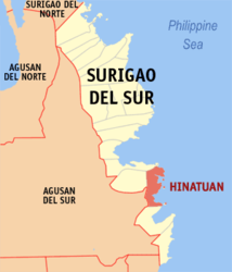
Basisdaten Bezirk: Caraga Provinz: Surigao del Sur Barangays: 24 Distrikt: 2. Distrikt von Surigao del Sur PSGC: 166809000 Einkommensklasse: 3. Einkommensklasse Haushalte: 6445 Zensus 1. Mai 2000Einwohnerzahl: 37.368 Zensus 1. August 2007Koordinaten: 8° 22′ N, 126° 20′ O8.3666666666667126.33333333333Koordinaten: 8° 22′ N, 126° 20′ O Postleitzahl: 8310 Bürgermeister: Candelario J. Viola Jr. Offizielle Webpräsenz: Hinatuan Geographische Lage auf den Philippinen 

Hinatuan Hinatuan ist eine philippinische Stadtgemeinde in der Provinz Surigao del Sur. Nach dem Zensus vom 1. Mai 2000 hat sie 36.170 Einwohner in 6445 Haushalten.
Baranggays
Hinatuan ist politisch in 24 Baranggays unterteilt.
- Baculin
- Benigno Aquino (Zone I Pob.)
- Bigaan
- Cambatong
- Campa
- Dugmanon
- Harip
- La Casa (Pob.)
- Loyola
- Maligaya
- Pagtigni-an (Bitoon)
- Pocto
- Port Lamon
- Roxas
- San Juan
- Sasa
- Tagasaka
- Tagbobonga
- Talisay
- Tarusan
- Tidman
- Tiwi
- Zone II (Pob.)
- Zone III Maharlika (Pob.)
Städte und Stadtgemeinden in der Provinz Surigao del SurStädte: Bislig City | Tandag City
Stadtgemeinden: Barobo | Bayabas | Cagwait | Cantilan | Carmen | Carrascal | Cortes | Hinatuan | Lanuza | Lianga | Lingig | Madrid | Marihatag | San Agustin | San Miguel | Tagbina | Tago (Surigao del Sur)
Wikimedia Foundation.
Schlagen Sie auch in anderen Wörterbüchern nach:
Hinatuan — Original name in latin Hinatuan Name in other language Hinatuan State code PH Continent/City Asia/Manila longitude 8.37222 latitude 126.33417 altitude 7 Population 10055 Date 2011 07 31 … Cities with a population over 1000 database
Hinatuan, Surigao del Sur — Hinatuan is a 3rd class municipality in the province of Surigao del Sur, Philippines. According to the 2000 census, it has a population of 36,170 people in 6,445 households.BarangaysHinatuan is politically subdivided into 24 barangays. * Baculin… … Wikipedia
List of islands of the Philippines — This is a list of islands of the Philippines. There are 7,107 islands, of which about 4,000 are inhabited. They are clustered into the island groups of Luzon, Visayas, and Mindanao.Luzon**Batanes Islands ***Batan Island ***Diadekey Island… … Wikipedia
Bislig City — Lage von Bislig in der Provinz Surigao del Sur Basisdaten Bezirk … Deutsch Wikipedia
PH-SUR — Lage der Provinz Surigao del Sur Surigao del Sur ist die 56. Provinz des Inselstaates der Philippinen. Sie befindet sich an der nordöstlichen Küste der Insel Mindanao und gehört politisch dem Regierungsbezirk Caraga (Region XIII) an. Der Sitz der … Deutsch Wikipedia
Surigao del Sur — Infobox Philippine province name = Surigao del Sur sealfile = Ph seal surigao del sur.png region = Caraga (Region XIII) capital = Tandag City founded = pop2000 = 501,808 pop2000rank = 49th largest popden2000 = 110 popden2000rank = 15th lowest… … Wikipedia
Basilan — Infobox Philippine province name = Basilan sealfile = ph seal basilan.png|100px region = Autonomous Region in Muslim Mindanao (ARMM) capital = Isabela City (Zamboanga Peninsula) founded = December 27, 1973 pop2000 = 496,503 pop2000rank = 20th… … Wikipedia
Bacuag, Surigao del Norte — Bacuag is a 5th class municipality in the province of Surigao del Norte, Philippines. According to the 2000 census, it has a population of 12,206 people in 2,333 households.The Muncicipality of Bacuag is situated along the northeastern coast of… … Wikipedia
Cortes, Surigao del Sur — Map of Surigao del Sur showing the location of Cortes Cortes is a 4th class municipality in the province of Surigao del Sur, Philippines. According to the 2000 Philippine census, it has a population of 14,825 people in 2,742 households. Contents … Wikipedia
Madrid, Surigao del Sur — Map of Surigao del Sur showing the location of Madrid Madrid is a 4th class municipality in the province of Surigao del Sur, Philippines. Madrid was named after the capital city of Spain, Madrid. It has 14 barangay s and two comprising the… … Wikipedia
Hinatuan


18+
© Academic, 2000-2024
- Kontaktieren Sie uns: Unterstützung, Werbung
Wörterbücher Export, schritte mit PHP, Joomla, Drupal, WordPress, MODx.