Icy Strait

Icy Strait
Icy Strait
Die Icy Strait
Die Icy Strait
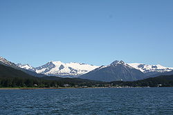
Verbindet Gewässer Cross Sound, Glacier Bay
mit Gewässer Chatham Strait, Lynn Canal
Trennt Landmasse Chichagof Island
von Landmasse amerikanisches Festland
Daten

Geographische Lage

58° 14′ N, 135° 27′ W58.232222222222-135.44638888889Koordinaten: 58° 14′ N, 135° 27′ W
Icy Strait (Alaska)
Icy Strait
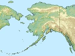
Länge 64 km
Inseln Pleasant Island, Lemesurier Island

Die Icy Strait ist eine 64 km lange Meerenge im südöstlichen Teil des US-Bundesstaats Alaska. Sie liegt im Alexanderarchipel und verläuft zwischen der Insel Chichagof im Süden und dem Festland im Norden.

Die Icy Strait erstreckt sich vom Kreuzungspunkt von Cross Sound und Glacier Bay im Westen zu dem von Chatham Strait und Lynn Canal im Osten. Die größten Inseln in der Meerenge sind Pleasant und Lemesurier Island.

Die Fähren des Alaska Marine Highways verkehren in der Icy Strait und laufen dort den Hafen von Hoonah an.

Weblinks

 Commons: Icy Strait – Sammlung von Bildern, Videos und Audiodateien

Wikimedia Foundation.

Игры ⚽ Поможем сделать НИР

Schlagen Sie auch in anderen Wörterbüchern nach:

  • Icy Strait — The Icy Strait is a strait in the Alexander Archipelago in southeastern Alaska, at about coord|58|14|N|135|30|W|. The strait separates Chichagof Island to the south and the Alaska mainland to the north. The strait is 64 km (40 miles) from its… …   Wikipedia

  • Chatham Strait — Mondaufgang in der Chatham Strait Verbindet Gewässer Icy Strait, Lynn Canal mit Gewässer …   Deutsch Wikipedia

  • Chatham Strait — For other uses, see Chatham (disambiguation). Moonrise in Chatham Strait Chatham Strait, or Shee ya xhaak in the Tlingit language, is a narrow passage of the Alexander Archipelago in the southeastern region of the U.S. state of Alaska. It… …   Wikipedia

  • Chatham Strait — Narrow passage, North Pacific Ocean. Extending off southeastern Alaska 150 mi (240 km) between the Admiralty and Kuiu islands on the east and the Chicagof and Baranof islands on the west, it is 3–10 mi (5–16 km) wide. It forms part of the Inside… …   Universalium

  • Davis Strait — Davis Strait, lying between Greenland and Nunavut, Canada.   Nunavut …   Wikipedia

  • Pleasant Island (Alaska) — Pleasant Island is the largest island in the Icy Strait between northern Chichagof Island and the mainland of the Alaska Panhandle. It lies southeast of the mainland city of Gustavus and southwest of the mainland community of Excursion Inlet.… …   Wikipedia

  • Isla de Chichagof — Isla Chichagof Chichagof Island Vista de satélite del archipiélago Alexander Localización País …   Wikipedia Español

  • Straße von Chatham — Mondaufgang in der Chatham Strait Die Chatham Strait ist eine entlang einer Verwerfung verlaufende Meerenge in der Panhandle des US Bundesstaats Alaska. Sie liegt im Alexanderarchipel und verläuft zwischen Chichagof Island und Baran …   Deutsch Wikipedia

  • Coastal Waters of Southeast Alaska and British Columbia — The Coastal Waters of Southeast Alaska and British Columbia is a marine area designated by the International Hydrographic Organization (IHO). It comprises waterbodies along the Pacific coast of British Columbia, Canada and the Alaska Panhandle,… …   Wikipedia

  • Hoonah, Alaska — Infobox Settlement official name = Hoonah, Alaska settlement type = City nickname = motto = imagesize = image caption = image mapsize = 250px map caption = Location of Hoonah, Alaska mapsize1 = map caption1 = pushpin pushpin label position = left …   Wikipedia

Share the article and excerpts

Direct link
Do a right-click on the link above
and select “Copy Link”