- Marion County (Iowa)
-
Verwaltung US-Bundesstaat: Iowa Verwaltungssitz: Knoxville Adresse des
Verwaltungssitzes:County Courthouse
214 East Main Street
Knoxville, IA 50138-0497Gründung: 1845 Vorwahl: 001 641 Demographie Einwohner: 33.309 (2010) Bevölkerungsdichte: 23,2 Einwohner/km² Geographie Fläche gesamt: 1.478 km² Wasserfläche: 42 km² Karte 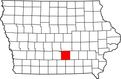
Website: co.marion.ia.us Das Marion County[2] ist ein County im Bundesstaat Iowa der Vereinigten Staaten von Amerika. Im Jahr 2010 hatte das County 33.309 Einwohner und eine Bevölkerungsdichte von 23,2 Einwohner pro Quadratkilometer. Der Verwaltungssitz (County Seat) ist Knoxville, benannt nach Henry Knox, einem General im amerikanischen Revolutionskrieg und erster US-Kriegsminister in Washington.
Inhaltsverzeichnis
Geografie
Das County liegt im mittleren Süden von Iowa, ist von Missouri etwa 70 km entfernt und hat eine Fläche von 1478 Quadratkilometern, wovon 42 Quadratkilometer Wasserfläche sind. Es grenzt im Uhrzeigersinn an folgende Countys: Jasper County, Mahaska County, Monroe County, Lucas County und Warren County.
Geschichte
Marion County wurde 1845 gebildet. Benannt wurde es nach General Francis Marion, einem Helden im Amerikanischen Unabhängigkeitskrieg.
Demografische Daten
Historische Einwohnerzahlen Census Einwohner ± in % 1850 5482 — 1860 16.813 200 % 1870 24.436 50 % 1880 25.111 3 % 1890 23.058 -8 % 1900 24.159 5 % 1910 22.995 -5 % 1920 24.957 9 % 1930 25.727 3 % 1940 27.019 5 % 1950 25.930 -4 % 1960 25.886 -0,2 % 1970 26.352 2 % 1980 29.669 10 % 1990 30.001 1 % 2000 32.052 7 % 2010 33.309 4 % Vor 1900[3] Nach der Volkszählung im Jahr 2000 lebten im Marion County 32.052 Menschen in 12.017 Haushalten und 8.532 Familien. Die Bevölkerungsdichte betrug 22 Einwohner pro Quadratkilometer. Ethnisch betrachtet setzte sich die Bevölkerung zusammen aus 97,46 Prozent Weißen, 0,42 Prozent Afroamerikanern, 0,19 Prozent amerikanischen Ureinwohnern, 1,03 Prozent Asiaten, 0,04 Prozent Bewohnern aus dem pazifischen Inselraum und 0,22 Prozent aus anderen ethnischen Gruppen; 0,64 Prozent stammten von zwei oder mehr Ethnien ab. 0,80 Prozent der Bevölkerung waren spanischer oder lateinamerikanischer Abstammung, die verschiedenen der genannten Gruppen angehörten.
Von den 12.017 Haushalten hatten 33,0 Prozent Kinder und Jugendliche unter 18 Jahre, die bei ihnen lebten. 61,2 Prozent waren verheiratete, zusammenlebende Paare, 6,9 Prozent waren allein erziehende Mütter, 29,0 Prozent waren keine Familien, 25,6 Prozent waren Singlehaushalte und in 11,9 Prozent lebten Menschen im Alter von 65 Jahren oder darüber. Die Durchschnittshaushaltsgröße betrug 2,50 und die durchschnittliche Familiengröße lag bei 3,02 Personen.
Auf das gesamte County bezogen setzte sich die Bevölkerung zusammen aus 25,3 Prozent Einwohnern unter 18 Jahren, 10,2 Prozent zwischen 18 und 24 Jahren, 26,5 Prozent zwischen 25 und 44 Jahren, 22,1 Prozent zwischen 45 und 64 Jahren und 15,9 Prozent waren 65 Jahre oder darüber. Das Durchschnittsalter betrug 37 Jahre. Auf 100 weibliche Personen kamen statistisch 98,6 männliche Personen. Auf 100 Frauen im Alter von 18 Jahren oder darüber kamen 95,8 Männer.
Das jährliche Durchschnittseinkommen eines Haushalts betrug 42.401 USD, das Durchschnittseinkommen der Familien betrug 50.052 USD. Männer hatten ein Durchschnittseinkommen von 36.460 USD, Frauen 25.573 USD. Das Pro-Kopf-Einkommen betrug 18.717 USD. 5,2 Prozent der Familien und 7,6 Prozent der Bevölkerung lebten unterhalb der Armutsgrenze.[6]
Städte und Gemeinden
- Beech
- Bussey
- Columbia
- Durham
- Hamilton
- Harvey
- Knoxville
- Marysville
- Melcher-Dallas
- Otley
- Painted Rocks
- Park Hills
- Pella
- Peoria
- Pershing
- Pleasantville
- Swan
- Tracy
Einzelnachweise
- ↑ Auszug aus dem National Register of Historic Places. Abgerufen am 13. März 2011
- ↑ Marion County im Geographic Names Information System des United States Geological Survey. Abgerufen am 27. Februar 2011
- ↑ U.S. Census Bureau - Census of Population and Housing. Abgerufen am 15. März 2011
- ↑ Auszug aus Census.gov Abgerufen am 16. Februar 2011
- ↑ United States Census 2010 Abgerufen am 27. Februar 2011
- ↑ Marion County, Iowa, Datenblatt mit den Ergebnissen der Volkszählung im Jahre 2000 bei factfinder.census.gov.
Weblinks
-
 Commons: Marion County, Iowa – Sammlung von Bildern, Videos und Audiodateien
 - Offizielle Webseite
- www.city-data.com

Liste der Countys in Iowa
Adair | Adams | Allamakee | Appanoose | Audubon | Benton | Black Hawk | Boone | Bremer | Buchanan | Buena Vista | Butler | Calhoun | Carroll | Cass | Cedar | Cerro Gordo | Cherokee | Chickasaw | Clarke | Clay | Clayton | Clinton | Crawford | Dallas | Davis | Decatur | Delaware | Des Moines | Dickinson | Dubuque | Emmet | Fayette | Floyd | Franklin | Fremont | Greene | Grundy | Guthrie | Hamilton | Hancock | Hardin | Harrison | Henry | Howard | Humboldt | Ida | Iowa | Jackson | Jasper | Jefferson | Johnson | Jones | Keokuk | Kossuth | Lee | Linn | Louisa | Lucas | Lyon | Madison | Mahaska | Marion | Marshall | Mills | Mitchell | Monona | Monroe | Montgomery | Muscatine | O'Brien | Osceola | Page | Palo Alto | Plymouth | Pocahontas | Polk | Pottawattamie | Poweshiek | Ringgold | Sac | Scott | Shelby | Sioux | Story | Tama | Taylor | Union | Van Buren | Wapello | Warren | Washington | Wayne | Webster | Winnebago | Winneshiek | Woodbury | Worth | Wright
Wikimedia Foundation.
Schlagen Sie auch in anderen Wörterbüchern nach:
Marion County, Iowa — For counties with a similar name, see Marion County (disambiguation). Marion County, Iowa Marion County Courthouse … Wikipedia
National Register of Historic Places listings in Marion County, Iowa — Location of Marion County in Iowa This is a list of the National Register of Historic Places listings in Marion County, Iowa. This is intended to be a complete list of the properties and districts on the National Register of Historic Places in… … Wikipedia
Marion County Courthouse (Iowa) — Marion County Courthouse U.S. National Register of Historic Places … Wikipedia
Marion County — is the name of seventeen counties in the United States of America, mostly named for General Francis Marion: Marion County, Alabama Marion County, Arkansas Marion County, Florida Marion County, Georgia Marion County, Illinois Marion County,… … Wikipedia
Iowa County (Iowa) — Iowa County Courthouse in Marengo, gelistet im NRHP Nr. 81000247[1] Verwaltung … Deutsch Wikipedia
Marion County — Es gibt in den Vereinigten Staaten 17 Countys mit dem Namen Marion County: Marion County (Alabama) Marion County (Arkansas) Marion County (Florida) Marion County (Georgia) Marion County (Illinois) Marion County (Indiana) Marion County (Iowa)… … Deutsch Wikipedia
Marion Township, Clayton County, Iowa — Marion Township Township Location in Clayton County … Wikipedia
Marion Township, Davis County, Iowa — Marion Township Township Location in Davis County … Wikipedia
Marion County Courthouse — or Old Marion County Courthouse may refer to: Marion County Courthouse (Arkansas), Yellville, Arkansas, listed on the NRHP in Marion County, Arkansas Marion County Courthouse (Buena Vista, Georgia), listed on the NRHP in Marion County, Georgia… … Wikipedia
Marion County Courthouse — bezeichnet mehrere gleichnamige, im NRHP gelistete, Objekte: Marion County Courthouse (Arkansas), ID Nr. 94000471 Marion County Courthouse (Georgia), ID Nr. 80001115 Marion County Courthouse (Iowa), ID Nr. 81000256 Marion County Courthouse… … Deutsch Wikipedia
Marion County (Iowa)


18+
© Academic, 2000-2024
- Kontaktieren Sie uns: Unterstützung, Werbung
Wörterbücher Export, schritte mit PHP, Joomla, Drupal, WordPress, MODx.